Rendition of pathogen contamination in a mixed land use watershed
Rendition of pathogen contamination in a mixed land use watershedArtist rendition of pathogen contamination in a mixed land use watershed.

Official websites use .gov
A .gov website belongs to an official government organization in the United States.
Secure .gov websites use HTTPS
A lock () or https:// means you’ve safely connected to the .gov website. Share sensitive information only on official, secure websites.
Upper Midwest Water Science Center images.

Artist rendition of pathogen contamination in a mixed land use watershed.
Artist rendition of pathogen contamination in a mixed land use watershed.

USGS scientists transferring material collected during microplastic sampling to glass mason jars.
USGS scientists transferring material collected during microplastic sampling to glass mason jars.
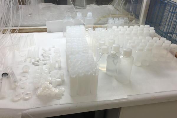
An assortment of Teflon equipment for trace metal sampling drying in a laminar flow hood.
An assortment of Teflon equipment for trace metal sampling drying in a laminar flow hood.

Root River at Greenfield showing damage from powerful high flows that are common to many urban streams.
Root River at Greenfield showing damage from powerful high flows that are common to many urban streams.

Passive samplers (on left: Polar Organic Chemical Integrative Sampler or “POCIS”; on right: mini-Semi-Permeable Membrane Devices or “SPMDs”) attached at depth in a stream for measurement of chemical contaminants.
Passive samplers (on left: Polar Organic Chemical Integrative Sampler or “POCIS”; on right: mini-Semi-Permeable Membrane Devices or “SPMDs”) attached at depth in a stream for measurement of chemical contaminants.

Passive samplers (POCIS and mini-SPMDs) deployed in stream for assessment of chemical contaminants in the water; a multi-parameter water-quality probe (on left) measures water temperature, pH, and specific conductance during initial deployment.
Passive samplers (POCIS and mini-SPMDs) deployed in stream for assessment of chemical contaminants in the water; a multi-parameter water-quality probe (on left) measures water temperature, pH, and specific conductance during initial deployment.

USGS scientist collecting sediment core from Little Menomonee River, Milwaukee, WI.
USGS scientist collecting sediment core from Little Menomonee River, Milwaukee, WI.

USGS scientist processing microplastic sample. Large net is washed to move plastics down the large net to the detachable cod-end at bottom for transfer to glass mason jars.
USGS scientist processing microplastic sample. Large net is washed to move plastics down the large net to the detachable cod-end at bottom for transfer to glass mason jars.

Surface water sampling for microplastics in Lake Michigan near Milwaukee, WI.
Surface water sampling for microplastics in Lake Michigan near Milwaukee, WI.

Custom-designed net for sampling microplastics at depth, Lake Michigan.
Custom-designed net for sampling microplastics at depth, Lake Michigan.

USGS scientist collecting velocity measurements and microplastic sampling at mid-depth within the water column, Menomonee River.
USGS scientist collecting velocity measurements and microplastic sampling at mid-depth within the water column, Menomonee River.

Crest stage streamgage at Lincoln Creek at Sherman Boulevard at Milwaukee, Wisconsin. https://waterdata.usgs.gov/monitoring-location/040869416
Crest stage streamgage at Lincoln Creek at Sherman Boulevard at Milwaukee, Wisconsin. https://waterdata.usgs.gov/monitoring-location/040869416

Sediment core from Kinnickinnic River.
Sediment core from Kinnickinnic River.

Stream habitat data is collected along a series of transects marked by tape measure and includes estimating rock size categories (for example, sand, gravel, cobble, boulders) with a guide (shown).
Stream habitat data is collected along a series of transects marked by tape measure and includes estimating rock size categories (for example, sand, gravel, cobble, boulders) with a guide (shown).

Stream habitat measurement showing meter stick and gravelometer used to measure channel depths and particle sizes.
Stream habitat measurement showing meter stick and gravelometer used to measure channel depths and particle sizes.

Bank height above the water surface is measured at each transect along a stream reach to estimate the channel and bed substrate as well as the type and size of sediment size that can be transported by the stream.
Bank height above the water surface is measured at each transect along a stream reach to estimate the channel and bed substrate as well as the type and size of sediment size that can be transported by the stream.

Hoan Bridge in Milwaukee, Wisocnsin with Lake Michigan in the background, taken from Inner Milwaukee Harbor.
Hoan Bridge in Milwaukee, Wisocnsin with Lake Michigan in the background, taken from Inner Milwaukee Harbor.

These photos, taken before and after a grassed-waterway conservation practice was installed, show a change in the water clarity of agricultural runoff at an edge-of-field surface monitoring site in Wisconsin.
These photos, taken before and after a grassed-waterway conservation practice was installed, show a change in the water clarity of agricultural runoff at an edge-of-field surface monitoring site in Wisconsin.
These photos show various edge-of-field monitoring surface and subsurface monitoring sites, installation efforts, and runoff events across the Great Lakes basin.
These photos show various edge-of-field monitoring surface and subsurface monitoring sites, installation efforts, and runoff events across the Great Lakes basin.

Sediment accumulation along a downstream concrete lined reach of the Kinnickinnic River, April 2016.
Sediment accumulation along a downstream concrete lined reach of the Kinnickinnic River, April 2016.

Both macro- and microplastics are contaminants of concern in freshwater environments. The drawing depicts the different types of plastics and the amorphous means by which they enter the Great Lakes environment. The backdrop is a conglomerate of different landscapes that represent the many different tributaries at which the study was conducted.
Both macro- and microplastics are contaminants of concern in freshwater environments. The drawing depicts the different types of plastics and the amorphous means by which they enter the Great Lakes environment. The backdrop is a conglomerate of different landscapes that represent the many different tributaries at which the study was conducted.