
A 53,000-pound vibroseis truck, with a hydraulic vibration plate that creates signals like tiny earthquakes. The truck is parked at a roadside pullout near the Continental Divide in Yellowstone National Park. Photo by Jamie Farrell, University of Utah, September 2020, taken under Yellowstone National Park research permit YELL-2020-SCI-8146.
Images
Volcano Science Center images.
Filter Total Items: 557
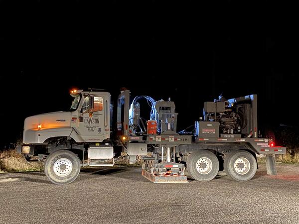
Vibroseis truck in Yellowstone National Park
A 53,000-pound vibroseis truck, with a hydraulic vibration plate that creates signals like tiny earthquakes. The truck is parked at a roadside pullout near the Continental Divide in Yellowstone National Park. Photo by Jamie Farrell, University of Utah, September 2020, taken under Yellowstone National Park research permit YELL-2020-SCI-8146.

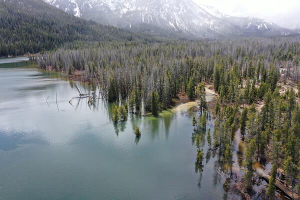
View of dead lodgepole pine trees with “bobby socks” in Lower Geyser Basin, Yellowstone National Park
View of dead lodgepole pine trees with “bobby socks” in Lower Geyser Basin, Yellowstone National ParkView of dead lodgepole pine trees with “bobby socks” from having taken up hydrothermal water that contains dissolved silica and other minerals. Photo taken south of the Fountain Paint Pot Trail in Lower Geyser Basin, Yellowstone National Park, looking toward the southeast. USGS photo by Stanley Mordensky, August 28, 2020.
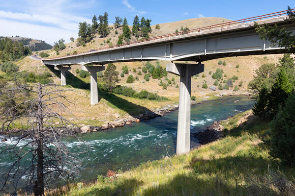
1960s-era bridge over the Yellowstone River near Tower Junction
1960s-era bridge over the Yellowstone River near Tower JunctionThe current bridge across the Yellowstone River near Tower Junction. The bridge was constructed in the early 1960s and has structural problems that require it to be replaced. The bridge will be removed once the new Yellowstone River Bridge is completed (scheduled for 2026). Photo by Jacob Frank (Yellowstone National Park) on August 17, 2020.

Twin Peaks, Beartooth Range, Montana
View of Twin Peaks (left-most prominent peak), Mt. Hague (second-left-most prominent peak), and Mt.
View of Twin Peaks (left-most prominent peak), Mt. Hague (second-left-most prominent peak), and Mt.

Mountain goat standing in front of Granite Peak, Beartooth Range, Montana
Mountain goat standing in front of Granite Peak, Beartooth Range, MontanaGranite Peak (center) as seen from the north flank of Tempest Mountain. Note: The photographer did not approach this mountain goat. Instead, the mountain goat, which has likely learned to associate human behavior as a source of sodium (a common problem throughout the region), approached the photographer. USGS photo by Stanley Mordensky, August 2020.

Sheep Mountain, Gallatin Range, Montana
Sheep Mountain, in the Gallatin Range, as seen from the north along the Sky Rim Trail near Sunlight Creek (to the left is approximately east, and to the right is approximately west). Note the layered stratigraphy of the sedimentary rocks dipping to the west. USGS photo by Stanley Mordensky, August 2020.
Sheep Mountain, in the Gallatin Range, as seen from the north along the Sky Rim Trail near Sunlight Creek (to the left is approximately east, and to the right is approximately west). Note the layered stratigraphy of the sedimentary rocks dipping to the west. USGS photo by Stanley Mordensky, August 2020.

Sapphire Pool, Yellowstone National Park
Sapphire Pool, in Biscuit Basin, steams on a stormy morning. A few “biscuits” remain along the pool’s southern edge (center right of photo) – violent geyser eruptions destroyed hundreds of the features when the pool’s plumbing system changed after being jarred by the 1959 Hebgen Lake earthquake. National Park Service photo by Jacob W. Frank, July 20, 2020.
Sapphire Pool, in Biscuit Basin, steams on a stormy morning. A few “biscuits” remain along the pool’s southern edge (center right of photo) – violent geyser eruptions destroyed hundreds of the features when the pool’s plumbing system changed after being jarred by the 1959 Hebgen Lake earthquake. National Park Service photo by Jacob W. Frank, July 20, 2020.

Photo of volcaniclastic units of the Absaroka volcanic province in northeastern Yellowstone National Park
Photo of volcaniclastic units of the Absaroka volcanic province in northeastern Yellowstone National ParkPhoto of geologic units of the Absaroka volcanic province in northeastern Yellowstone National Park that shows volcaniclastic sandstones grading up into a conglomerate, followed by another sequence of sandstone to conglomerate. These repeating layers of the same-looking material make it difficult to assign them to a specific volcanic group.
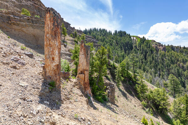
Standing petrified (silicified) trees on Specimen Ridge in northeastern Yellowstone National Park.
Standing petrified (silicified) trees on Specimen Ridge in northeastern Yellowstone National Park.Two standing petrified (silicified) trees on Specimen Ridge in northeastern Yellowstone National Park. Photo by Jacob W. Frank, Yellowstone National Park (https://www.flickr.com/photos/yellowstonenps/50016729252).

Petrified trees on Specimen Ridge, Yellowstone National Park
Petrified trees on Specimen Ridge, Yellowstone National ParkPetrified trees on Specimen Ridge, Yellowstone National Park. NPS photo by Jake Frank, June 13, 2020.
Petrified trees on Specimen Ridge, Yellowstone National Park
Petrified trees on Specimen Ridge, Yellowstone National ParkPetrified trees on Specimen Ridge, Yellowstone National Park. NPS photo by Jake Frank, June 13, 2020.
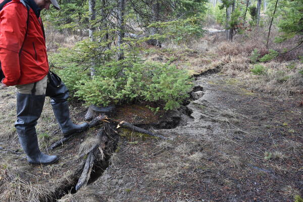
Ground fissure along the shore of Stanley Lake, Idaho, resulting from March 31, 2020, earthquake
Ground fissure along the shore of Stanley Lake, Idaho, resulting from March 31, 2020, earthquakeGround fissure along the shore of Stanley Lake, Idaho, cause by liquefaction during shaking from the March 31, 2020, Stanley earthquake. Photo by Zach Lifton, Idaho Geological Survey, May 2020.
Submerged trees at the inlet delta of Stanley Lake, Idaho, due to March 31, 2020, earthquake
Submerged trees at the inlet delta of Stanley Lake, Idaho, due to March 31, 2020, earthquakeSubmerged trees at the inlet delta of Stanley Lake, Idaho. Liquefaction during shaking from the March 31, 2020, Stanley earthquake caused ground subsidence and collapse of the delta. Photo by Zach Lifton, Idaho Geological Survey, May 2020.

“Did You Feel It?” reports for the March 31, 2020, M6.5 Stanley, Idaho, earthquake
“Did You Feel It?” reports for the March 31, 2020, M6.5 Stanley, Idaho, earthquakeMap of USGS “Did You Feel It?” reports for the March 31, 2020, M6.5 Stanley, Idaho, earthquake. Taken from https://earthquake.usgs.gov/earthquakes/eventpage/us70008jr5/dyfi/intensity.

Annie Carlson, Research Permitting Coordinator for Yellowstone National Park during 2017–2023, during a winter ski expedition in the park
Annie Carlson, Research Permitting Coordinator for Yellowstone National Park during 2017–2023, during a winter ski expedition in the parkAnnie Carlson, Research Permitting Coordinator for Yellowstone National Park during 2017–2023, during a winter ski expedition in the park. National Park Service photo by Jon Nicholson, January 2020.

Sabrina Brown collecting samples from Yellowstone Lake core YL16-2C
Sabrina Brown collecting samples from Yellowstone Lake core YL16-2CSabrina Brown collecting samples from Yellowstone Lake core YL16-2C at the National Lacustrine Core Facility (LacCore) at the University of Minnesota.
Sabrina Brown collecting samples from Yellowstone Lake core YL16-2C
Sabrina Brown collecting samples from Yellowstone Lake core YL16-2CSabrina Brown collecting samples from Yellowstone Lake core YL16-2C at the National Lacustrine Core Facility (LacCore) at the University of Minnesota.

A novel HCl/HF analyzer
State-of-art, cavity-enhanced analyzer to help solve this long-standing technical problem in volcano science, adapted from an industrial instrument. The Off-Axis Integrated Cavity Output Spectroscopy (OA-ICOS) yields a several kilometer path length for absorption. Contains two near-IR tunable diode lasers and is field portable, fast, and precise.
State-of-art, cavity-enhanced analyzer to help solve this long-standing technical problem in volcano science, adapted from an industrial instrument. The Off-Axis Integrated Cavity Output Spectroscopy (OA-ICOS) yields a several kilometer path length for absorption. Contains two near-IR tunable diode lasers and is field portable, fast, and precise.

Mineral stability diagram showing minerals that are stable under changing temperature and dissolved silica concentrations at and just beneath the floor of Yellowstone Lake
Mineral stability diagram showing minerals that are stable under changing temperature and dissolved silica concentrations at and just beneath the floor of Yellowstone LakeMineral stability diagram showing minerals that are stable under changing temperature and dissolved silica concentrations that are found at and just beneath the floor of Yellowstone Lake. Two important points illustrated by this diagram are: (1) the minerals that are stable when reacted with vapor-dominated fluids (kaolinite, boehmite) differ substantially fro
Mineral stability diagram showing minerals that are stable under changing temperature and dissolved silica concentrations at and just beneath the floor of Yellowstone Lake
Mineral stability diagram showing minerals that are stable under changing temperature and dissolved silica concentrations at and just beneath the floor of Yellowstone LakeMineral stability diagram showing minerals that are stable under changing temperature and dissolved silica concentrations at and just beneath the floor of Yellowstone Lake
Mineral stability diagram showing minerals that are stable under changing temperature and dissolved silica concentrations at and just beneath the floor of Yellowstone LakeMineral stability diagram showing minerals that are stable under changing temperature and dissolved silica concentrations that are found at and just beneath the floor of Yellowstone Lake. Two important points illustrated by this diagram are: (1) the minerals that are stable when reacted with vapor-dominated fluids (kaolinite, boehmite) differ substantially fro

Box diagram and map showing sources and fate of geothermal solutes in the Yellowstone River
Box diagram and map showing sources and fate of geothermal solutes in the Yellowstone RiverThe Yellowstone River is divided into five reaches (labeled and color-coded): Yellowstone Lake, Hayden Valley, Grand Canyon of the Yellowstone, Tower–Gardner, and Mammoth. Monitoring stations (yellow dots on map) between each reach of the river reaches allow geochemists to measure river composition and then determine the sources of chloride (Cl) and other solu

Small acidic hot spring in the Gibbon Geyser Basin of Yellowstone National Park
Small acidic hot spring in the Gibbon Geyser Basin of Yellowstone National ParkAn unnamed small acidic (pH ~3) hot spring (with a temperature of about 55°C at the source) in the Gibbon Geyser Basin of Yellowstone National Park. The yellow region is due to the precipitation of sulfur by sulfide-oxidizing chemotrophic microorganisms.
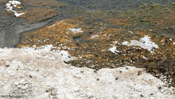
Adult tiger beetles near Midway Geyser Basin, Yellowstone National Park
Adult tiger beetles near Midway Geyser Basin, Yellowstone National ParkSeveral adult wetsalts tiger beetles hunting and basking on and around an alkaline hot spring near Midway Geyser Basin in Yellowstone National Park. Photo by Robert K. D. Peterson, 2019.

Image of Yellowstone Lake showing location of core YL16-2C
Image of Yellowstone Lake showing location of core YL16-2CA digital elevation map of Yellowstone National Park (left) with the location of Yellowstone Lake indicated by the white box. Satellite image (right) of the study site with collection location of core YL16-2C shown by the red circle. Map was originally published in Sabrina Brown’s dissertation (2019).