
Pacific Cod (Gadus macrocephalus). Also known as Cod, Alaska Cod, Gray Cod, and True Cod. Courtesy of NOAA Fisheries.
Images
A picture is worth a thousand words. Take a look at some images capturing science activities at the USGS Wetland and Aquatic Research Center.
Filter Total Items: 211
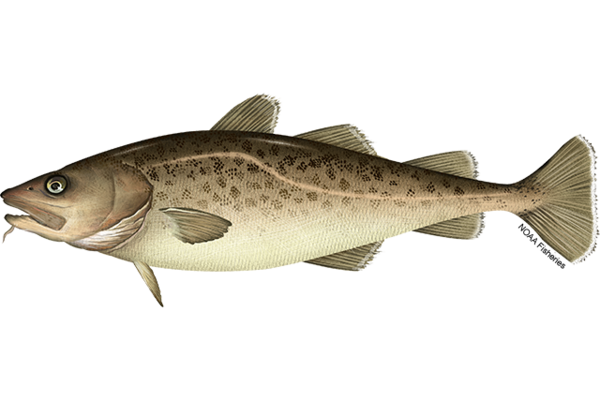
Pacific Cod (Gadus macrocephalus)
Pacific Cod (Gadus macrocephalus). Also known as Cod, Alaska Cod, Gray Cod, and True Cod. Courtesy of NOAA Fisheries.
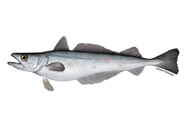
Pacific Hake or Pacific Whiting (Merluccius productus)
Pacific Hake or Pacific Whiting (Merluccius productus)Pacific Hake or Pacific Whiting (Merluccius productus). Ray-finned fish species found off the U.S. and Canada western coasts. Courtesy of NOAA Fisheries.
Pacific Hake or Pacific Whiting (Merluccius productus)
Pacific Hake or Pacific Whiting (Merluccius productus)Pacific Hake or Pacific Whiting (Merluccius productus). Ray-finned fish species found off the U.S. and Canada western coasts. Courtesy of NOAA Fisheries.
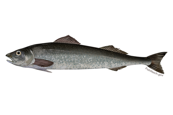
Sablefish or Black Cod (Anoplopoma fimbria)
Sablefish or Black Cod (Anoplopoma fimbria). A deep-sea fish species native to the Pacific Northwest and Alaska. Courtesy of NOAA Fisheries.
Sablefish or Black Cod (Anoplopoma fimbria). A deep-sea fish species native to the Pacific Northwest and Alaska. Courtesy of NOAA Fisheries.
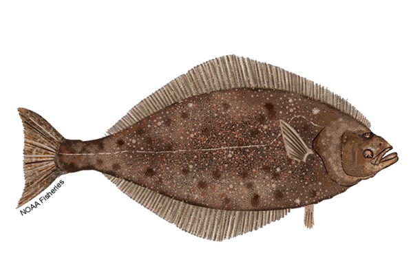
Pacific Halibut (Hippoglossus stenolepis)
Pacific Halibut (Hippoglossus stenolepis). Also known as Halibut or Alaskan Halibut. It is the largest flatfish species. Courtesy of NOAA Fisheries.
Pacific Halibut (Hippoglossus stenolepis). Also known as Halibut or Alaskan Halibut. It is the largest flatfish species. Courtesy of NOAA Fisheries.

Scientists process sediment cores from the deep sea
Scientists process sediment cores from the deep seaTo help study the biodiversity present in the deep sea, scientists collect sediment cores. These cores are about a foot long and provide a vertical profile of deep-sea sediment, or mud.
Scientists process sediment cores from the deep sea
Scientists process sediment cores from the deep seaTo help study the biodiversity present in the deep sea, scientists collect sediment cores. These cores are about a foot long and provide a vertical profile of deep-sea sediment, or mud.

Reported lionfish sightings from 1985 - January 8, 2020
Reported lionfish sightings from 1985 - January 8, 2020Reported lionfish sightings from 1985 - January 8, 2020
Data Source: U.S. Geological Survey, Nonindigenous Aquatic Species Database
Reported lionfish sightings from 1985 - January 8, 2020
Reported lionfish sightings from 1985 - January 8, 2020Reported lionfish sightings from 1985 - January 8, 2020
Data Source: U.S. Geological Survey, Nonindigenous Aquatic Species Database

SuBastian’s manipulator jaw stabilizes GEOMAR’s glowing bubble box
SuBastian’s manipulator jaw stabilizes GEOMAR’s glowing bubble boxROV SuBastian’s manipulator jaw stabilizes GEOMAR’s glowing bubble box that is capturing high-resolution images of methane bubbles rising from the seafloor.
SuBastian’s manipulator jaw stabilizes GEOMAR’s glowing bubble box
SuBastian’s manipulator jaw stabilizes GEOMAR’s glowing bubble boxROV SuBastian’s manipulator jaw stabilizes GEOMAR’s glowing bubble box that is capturing high-resolution images of methane bubbles rising from the seafloor.

UNC mini landers surrounded by Sablefish
Two UNC mini landers, surrounded by Sablefish (Anoplopoma fimbria) and pink sea urchins, incubate seawater in situ to enable calculations of methane oxidation rates.
Two UNC mini landers, surrounded by Sablefish (Anoplopoma fimbria) and pink sea urchins, incubate seawater in situ to enable calculations of methane oxidation rates.

Red plumes burst out from the tops of these chemosynthetic tubeworms
Red plumes burst out from the tops of these chemosynthetic tubewormsRed plumes burst out from the tops of these chemosynthetic tubeworms, capturing hydrogen sulfide and oxygen from the surrounding water to feed their bacterial endosymbionts. The tubeworm tubes provide a habitat for several benthic animals, including the pale pink branching octocorals seen here

Finley, a female Kemp's ridley sea turtle
A female Kemp's ridley sea turtle, named Finley, shows off the popoff ADL (orange) and satellite tag (blue).
A female Kemp's ridley sea turtle, named Finley, shows off the popoff ADL (orange) and satellite tag (blue).

Mangrove forest in Pohnpei, Micronesia
Mangrove forest in Pohnpei, Micronesia.
The USGS and partners are studying how mangrove forests in the Federated States of Micronesia may respond to sea-level rise over the coming century. Their projections will help Micronesian communities plan for the future.
Mangrove forest in Pohnpei, Micronesia.
The USGS and partners are studying how mangrove forests in the Federated States of Micronesia may respond to sea-level rise over the coming century. Their projections will help Micronesian communities plan for the future.

Red Sea Urchins
Two red sea urchins (Mesocentrotus franciscanus) sit on the deck of the R/V Falkor. These sea urchins were collected during the #HuntingBubbles research cruise led by the USGS and Schmidt Ocean Institute, which focused on exploring and understanding methane seeps and the communities that depend on them along the Cascadia Margin.
By
Ecosystems, Natural Hazards, Coastal and Marine Hazards and Resources Program, Environments Program, Pacific Coastal and Marine Science Center, St. Petersburg Coastal and Marine Science Center, Wetland and Aquatic Research Center , Woods Hole Coastal and Marine Science Center, Communications and Publishing

A sea turtle mosaic made from the field station's broken floor tiles
A sea turtle mosaic made from the field station's broken floor tilesAfter Hurricane Michael obliterated Fish Inn, the sea turtle research team's field station, team members salvaged some of the building's floor tiles and made this sea turtle mosaic, which they plan to eventually install in a new field station.

Gulf Coast Waterdog - Necturus beyeri
Source: USGS National Wetlands Research Center. Photographer: Brad M. Glorioso. St. Tammany Parish, Louisiana
Necturus beyeri - Gulf Coast Waterdog
Source: USGS National Wetlands Research Center. Photographer: Brad M. Glorioso. St. Tammany Parish, Louisiana
Necturus beyeri - Gulf Coast Waterdog

Cape San Blas Road, before and after a Category 5 hurricane
Cape San Blas Road, before and after a Category 5 hurricaneThese two NOAA satellite images show Cape San Blas Road in the Florida Panhandle town of Cape San Blas before Hurricane Michael, and after the Category 5 storm. The red circle shows where the USGS sea turtle researchers' field station and seasonal home once stood. The building was demolished down to the concrete slab.
Releasing a loggerhead with radio tag
A loggerhead sea turtle, outfitted with a popoff ADL package (orange item on the turtle’s back), is released by New England Aquarium Biologist Nick Whitney.
A loggerhead sea turtle, outfitted with a popoff ADL package (orange item on the turtle’s back), is released by New England Aquarium Biologist Nick Whitney.

Manatee Health Assessment
USGS conducts a health assessment on a mantee in Crystal River, Florida.
USGS conducts a health assessment on a mantee in Crystal River, Florida.

Dauphin Island, Alabama
A view of a vegetated inland coastline overlooking the water on Dauphin Island, Alabama. The island protects mainland Alabama’s coastal communities and resources from storms, while also providing recreational opportunities (fishing, beach tourism, etc.) and other economic benefits to the local community and state.
A view of a vegetated inland coastline overlooking the water on Dauphin Island, Alabama. The island protects mainland Alabama’s coastal communities and resources from storms, while also providing recreational opportunities (fishing, beach tourism, etc.) and other economic benefits to the local community and state.

Dauphin Island, Alabama
A panoramic view on Dauphin Island, Alabama. The island protects mainland Alabama’s coastal communities and resources from storms, while also providing recreational opportunities (fishing, beach tourism, etc.) and other economic benefits to the local community and state.
A panoramic view on Dauphin Island, Alabama. The island protects mainland Alabama’s coastal communities and resources from storms, while also providing recreational opportunities (fishing, beach tourism, etc.) and other economic benefits to the local community and state.

A broken slab is all that's left of Fish Inn after Hurricane Michael
A broken slab is all that's left of Fish Inn after Hurricane MichaelA broken concrete foundation and some shattered floor tiles were all that remained of the sea turtle researchers' field station and home base after Category Four Hurricane Michael struck Cape San Blas on Oct. 10, 2018.

Hurricane Michael cut deep into Panhandle dunes
A deeply eroded sand dune on the beach at Cape San Blas shows Hurricane Michael's impact on parts of the Florida Panhandle shoreline.
A deeply eroded sand dune on the beach at Cape San Blas shows Hurricane Michael's impact on parts of the Florida Panhandle shoreline.