
Advanced Tools/Technology Development
Advanced Tools/Technology Development
Filter Total Items: 52
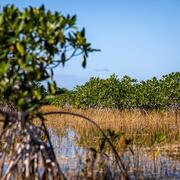
Engaging Indigenous Communities to Co-Design a Web Application to Protect Everglades Tree Islands
The USGS collaborated with the Miccosukee and Seminole Tribes to co-design a dashboard mock-up for a real-time web application that monitors tree island health in the Everglades.
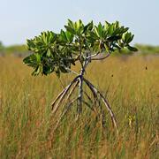
Developing a Roadmap for the Future of Natural Resources in Everglades National Park
To sustain economic and ecologically viable ecosystems into the future, USGS is developing freshwater delivery targets for water flowing southward into Everglades National Park by integrating climate and sea level projections, hydrologic modeling, and ecological modeling to forecast ecosystem responses to future freshwater availability scenarios.
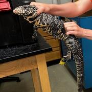
Early detection and rapid response tools for invasive tegu lizards
Scientists at USGS have shown that much of the US is suitable for invasion by tegu lizards, and suitability will likely increase in the future. While tegus can be removed via trapping, it is difficult to monitor every geographic area where tegus could invade. Thus, methods for quickly detecting and removing tegus in new areas are the best way to prevent spread and minimize damage from these...

Population Ecology of Florida Manatees
USGS is working with partners to understand how the federally protected Florida manatee ( Trichechus manatus latirostris) population changes over time and responds to threats.

Spatial Analysis Support for Coastal Wetlands Planning, Protection and Restoration Act (Breaux Bill) Planning Activities
WARC first implemented geographic information systems (GIS) in 1980 to help monitor the nature and extent of wetland habitat changes. The center continues to use GIS, remote sensing, and other computer based technologies to address a wide range of natural resource related issues.

Louisiana’s Coastwide Reference Monitoring System (CRMS)
The Coastwise Reference Monitoring System was designed to monitor the effectiveness of restoration actions at individual sites, as well as across the entire Louisiana coast.

Spatial Analysis of Coastal Wetlands Planning, Protection and Restoration Act Projects
As the first federally mandated restoration program, Louisiana enacted the Coastal Wetlands Planning, Protection and Restoration Act (CWPPRA) to address Louisiana’s land loss crisis.

Tracking and Modeling the Population of the Louisiana Black Bear Using “BearTRAK”
"BearTrak" is an app that provides a central repository for Louisiana black bear tracking data, allowing managers to access information more quickly and reliably. USGS science was used in the decision to delist the species from the Endangered Species Act in 2016. Louisiana Department of Wildlife and Fisheries continues to monitor the Louisiana black bear population.

GIS and Custom Application Support for the Gulf Coast Ecosystem Restoration Council
The scientists at the Wetland and Aquatic Science Center (WARC) have provided coastal restoration project managers and decision makers with GIS planning, database and custom application capacity since 1992. The scope and complexity of this support has increased over the years and has resulted in the development of a comprehensive geospatial and advanced application teams that provide decision...

A Multiscale Approach to Understanding Migratory Landbird Habitat Use of Functional Stopover Habitat Types and Management Efforts
USGS scientists are using a spatially-explicit Bayesian network model to predict the difference between energetic value and energetic demand for stopover habitats for migrating landbirds.

Developing General Coastal Vegetation Maps for Coastal Morphodynamic Models
The USGS is collaborating with researchers from other agencies, academia, and industry to predict coastal impacts from hurricanes. The results from this study will better inform coastal morphological change models, which will lead to improved hurricane impact projections.

Flow Cytometry Applied to the Animal Kingdom in Studies of Natural Resource Science
Flow cytometry is a technique for rapidly analyzing large numbers of animal cells using light-scattering, fluorescence, and absorbance measurements.