
Mira Anderberg and Marie Bartlett (USGS) digging up a fence post that had a pressure sensor attached to measure storm surge and flooding during Hurricane Lee.
Images
Woods Hole Coastal and Marine Science Center images
Filter Total Items: 1312

Hurricane Lee sensor recovery
Mira Anderberg and Marie Bartlett (USGS) digging up a fence post that had a pressure sensor attached to measure storm surge and flooding during Hurricane Lee.

Hurricane Lee sensor retrieval
Marie Bartlett (USGS) removes fence post at Marconi Beach in Wellfleet, MA while recovering pressure sensor. Pressure sensors were attached to fence posts and hammered into the sand to measure total water levels of Hurricane Lee. Photo by Jin-Si Over, USGS.
Marie Bartlett (USGS) removes fence post at Marconi Beach in Wellfleet, MA while recovering pressure sensor. Pressure sensors were attached to fence posts and hammered into the sand to measure total water levels of Hurricane Lee. Photo by Jin-Si Over, USGS.

USGS Scientists and Survey Technicians deploying geophysical survey systems on the R/V Pelican in the Gulf of Mexico
USGS Scientists and Survey Technicians deploying geophysical survey systems on the R/V Pelican in the Gulf of MexicoUSGS Scientists and Survey Technicians from the Woods Hole Coastal and Marine Science Center (Laura Brothers, Dave Foster, Pat Berube and Chuck Worley) deploying geophysical survey systems on the R/V Pelican in the Gulf of Mexico.
Fall 2023 Photo Contest Winner: Seth Ackerman, Honorable Mention category

Hurricane Lee storm surge
Hurricane Lee storm surge at Head of the Meadow Beach in Truro, Massachusetts on September 16, 2023.
Hurricane Lee storm surge at Head of the Meadow Beach in Truro, Massachusetts on September 16, 2023.

Hurricane Lee buoy deployment
Dr. John Warner, USGS, and Dr. Martha Schonau, Scripps, before deploying 11 buoys from a U.S. Navy P3 Orion aircraft from the VXS-1 squadron based out of Naval Air Station Patuxent River in Maryland. These buoys measure waves, temperature, and physical ocean properties.
Dr. John Warner, USGS, and Dr. Martha Schonau, Scripps, before deploying 11 buoys from a U.S. Navy P3 Orion aircraft from the VXS-1 squadron based out of Naval Air Station Patuxent River in Maryland. These buoys measure waves, temperature, and physical ocean properties.

Hurricane Lee drone imagery
USGS scientists Jen Cramer and Jin-Si Over pilot a drone at Nauset Light Beach in Nauset, MA. Drone imagery will be used to monitor coastal change before and after Hurricane Lee. Photo by Mira Anderberg, USGS.
USGS scientists Jen Cramer and Jin-Si Over pilot a drone at Nauset Light Beach in Nauset, MA. Drone imagery will be used to monitor coastal change before and after Hurricane Lee. Photo by Mira Anderberg, USGS.

Hurricane Lee sensor installation
Eric Marsjanik and Jin-Si Over (USGS) installing pressure sensors attached to 8-foot fence posts marked with buoys and anchors to measure storm surge and flooding caused by Hurricane Lee.
Eric Marsjanik and Jin-Si Over (USGS) installing pressure sensors attached to 8-foot fence posts marked with buoys and anchors to measure storm surge and flooding caused by Hurricane Lee.

Hurricane Lee sensor deployment
Robert Bales (USGS) attaches a pressure sensor to post in the Sandwich Marsh tidal creek in Sandwich, MA to measure the water level during the storm. Photo by Chris Sherwood, USGS.
Robert Bales (USGS) attaches a pressure sensor to post in the Sandwich Marsh tidal creek in Sandwich, MA to measure the water level during the storm. Photo by Chris Sherwood, USGS.

Salt marsh along the Herring River
A salt marsh along the Herring River at the National Park Service’s Cape Cod National Seashore in Massachusetts. USGS scientists and partners are applying the mineral olivine to the marsh to study its role in capturing carbon dioxide in tidal wetlands.
A salt marsh along the Herring River at the National Park Service’s Cape Cod National Seashore in Massachusetts. USGS scientists and partners are applying the mineral olivine to the marsh to study its role in capturing carbon dioxide in tidal wetlands.

Salt marsh along the Herring River
A salt marsh along the Herring River at the National Park Service’s Cape Cod National Seashore in Massachusetts. USGS scientists and partners are applying the mineral olivine to the marsh to study its role in capturing carbon dioxide in tidal wetlands. Credit: Kevin Kroeger, USGS.
A salt marsh along the Herring River at the National Park Service’s Cape Cod National Seashore in Massachusetts. USGS scientists and partners are applying the mineral olivine to the marsh to study its role in capturing carbon dioxide in tidal wetlands. Credit: Kevin Kroeger, USGS.

sUAS at Darby Creek Superfund Site
Preliminary lidar data collected in the John Heinz Wildlife Refuge as a baseline for future topography change.
Preliminary lidar data collected in the John Heinz Wildlife Refuge as a baseline for future topography change.

sUAS at Darby Creek Superfund Site
Preliminary lidar data collected in the John Heinz Wildlife Refuge as a baseline for future topography change.
Preliminary lidar data collected in the John Heinz Wildlife Refuge as a baseline for future topography change.

Hurricane Lee buoy deployment
The USGS and partners prepare to deploy 11 buoys into the Gulf of Maine from a U.S. Navy aircraft in preparation for Hurricane Lee. These buoys measure waves, temperature, and physical ocean properties.
The USGS and partners prepare to deploy 11 buoys into the Gulf of Maine from a U.S. Navy aircraft in preparation for Hurricane Lee. These buoys measure waves, temperature, and physical ocean properties.
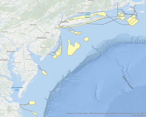
Offshore Wind Lease Outlines
Offshore wind lease polygons retrieved from the 'Offshore Wind Lease Outlines' feature class available on Marine Cadastre.
Offshore wind lease polygons retrieved from the 'Offshore Wind Lease Outlines' feature class available on Marine Cadastre.
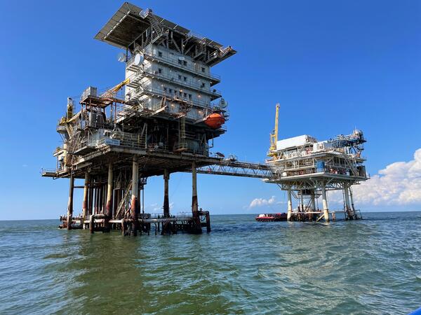
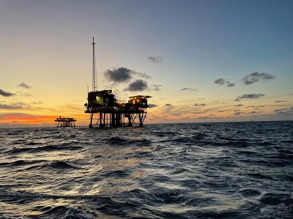
Offshore infrastructure
Photo of offshore infrastructure. Offshore Louisiana, September 2023—photo by L. Brothers.
Photo of offshore infrastructure. Offshore Louisiana, September 2023—photo by L. Brothers.
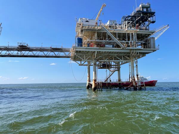
Offshore infrastructure
Photo of offshore infrastructure. Offshore Louisiana, September 2023—photo by L. Brothers.
Photo of offshore infrastructure. Offshore Louisiana, September 2023—photo by L. Brothers.

sUAS at Darby Creek Superfund Site
USGS sUAS pilots with Josh Barber from the EPA and a sUAS with the lidar payload mounted and ready to fly over the John Heinz Wildlife Refuge.
USGS sUAS pilots with Josh Barber from the EPA and a sUAS with the lidar payload mounted and ready to fly over the John Heinz Wildlife Refuge.
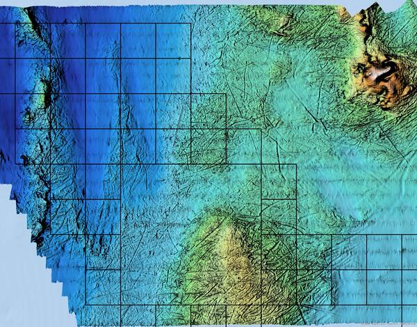
Bathymetric data
Bathymetric data in and around lease area OCS-A-0567 that resolves iceberg scours and seafloor mounds.
Bathymetric data in and around lease area OCS-A-0567 that resolves iceberg scours and seafloor mounds.
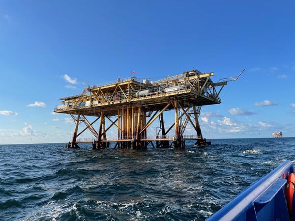
Offshore Infrastructure
Photo of offshore infrastructure. Offshore Louisiana, September 2023—photo by L. Brothers.
Photo of offshore infrastructure. Offshore Louisiana, September 2023—photo by L. Brothers.
Offshore infrastructure
Photo of offshore infrastructure. Offshore Louisiana, September 2023—photo by L. Brothers.
Photo of offshore infrastructure. Offshore Louisiana, September 2023—photo by L. Brothers.

sUAS at Darby Creek Superfund Site
Jin-Si Over (WHCMSC) and Chris Gazoorian (NYWSC) preparing to fly the YellowScan Mapper+ to collect lidar data on the ClearView Landfill.
Jin-Si Over (WHCMSC) and Chris Gazoorian (NYWSC) preparing to fly the YellowScan Mapper+ to collect lidar data on the ClearView Landfill.