
The beach-dependent shorebirds project at the Woods Hole Coastal and Marine Science Center models current and future habitat availability for nesting shorebirds in an effort to map current and likely future habitat availability on a range of sites along the U.S. Atlantic coast.
Images
Woods Hole Coastal and Marine Science Center images
Filter Total Items: 1334

Piping Plover Habitat, Cedar Island
The beach-dependent shorebirds project at the Woods Hole Coastal and Marine Science Center models current and future habitat availability for nesting shorebirds in an effort to map current and likely future habitat availability on a range of sites along the U.S. Atlantic coast.

Map of the Martha’s Vineyard and Nantucket study sites outlined in red
Map of the Martha’s Vineyard and Nantucket study sites outlined in redMap of the Martha’s Vineyard and Nantucket study sites outlined in red.
Map of the Martha’s Vineyard and Nantucket study sites outlined in red
Map of the Martha’s Vineyard and Nantucket study sites outlined in redMap of the Martha’s Vineyard and Nantucket study sites outlined in red.

Map of Massachusetts and the Islands
Study site map for the Massachusetts Shoreline Change Project, 2018 Update: A GIS Compilation of Shoreline Change Rates Calculated Using Digital Shoreline Analysis System Version 5.0, With Supplementary Intersects and Baselines for Massachusetts
Study site map for the Massachusetts Shoreline Change Project, 2018 Update: A GIS Compilation of Shoreline Change Rates Calculated Using Digital Shoreline Analysis System Version 5.0, With Supplementary Intersects and Baselines for Massachusetts

R/V Petrel
R/V Petrel surveying off Beach Haven, NJ during USGS FA 2018-001-FA
R/V Petrel surveying off Beach Haven, NJ during USGS FA 2018-001-FA

Simulation of wave-driven flooding on Marshall Island
Simulation of wave-driven flooding on Marshall IslandReefs provide protection from waves and wave-driven flooding. A snapshot from the simulation of wave-driven flooding and island overwash for an annual storm at the Republic of the Marshall Islands is shown.

Hurricane Florence Modeling
First arrival times of contaminants at each location (lighter colors indicate longer time since the storm) for conditions observed during Hurricane Florence (top), and two hypothetical events: one with smaller rainfall (middle) and another with a different post-storm wind pattern (bottom).
First arrival times of contaminants at each location (lighter colors indicate longer time since the storm) for conditions observed during Hurricane Florence (top), and two hypothetical events: one with smaller rainfall (middle) and another with a different post-storm wind pattern (bottom).

Elevation data for land and submerged areas, Barnegat Bay, NJ
Elevation data for land and submerged areas, Barnegat Bay, NJCoastal storms can severely alter the topography and ecosystems along heavily populated coastal regions. Seamless integrated elevation data for both land and submerged areas in Barnegat Bay, New Jersey, are fundamental to coastal planning of the northeastern U.S. Atlantic coast.

Diver in cave
Cave passage and diver (Bil Philips, cave explorer) in Ox Bel Ha Cave System of the northeastern Yucatan Peninsula.
Cave passage and diver (Bil Philips, cave explorer) in Ox Bel Ha Cave System of the northeastern Yucatan Peninsula.
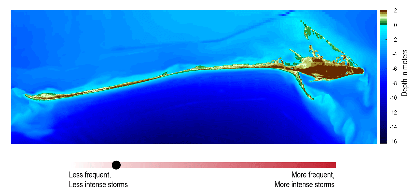
Storm and sea level rise scenario model for Dauphin Island, Alabama
Storm and sea level rise scenario model for Dauphin Island, AlabamaStorm and sea level rise scenario models, like the one shown here, can be used to explore the future. This model shows what Dauphin Island may look like 10 years from now if storms become stronger and more frequent (Passeri and others, 2018).

Gas Hydrates and Gas Bubbles
Gas hydrate (orange material) and gas bubbles near the seafloor in the northern Gulf of America. As the methane bubbles are emitted, a rind of gas hydrate immediately forms around some of them. If more bubbles continue to feed from below, gas hydrate forms.
Gas hydrate (orange material) and gas bubbles near the seafloor in the northern Gulf of America. As the methane bubbles are emitted, a rind of gas hydrate immediately forms around some of them. If more bubbles continue to feed from below, gas hydrate forms.

Part of the Akumal Coastline
Part of the Akumal coastline in Quintana Roo, Mexico, near where the Ox Bel Ha cave system is located.
Part of the Akumal coastline in Quintana Roo, Mexico, near where the Ox Bel Ha cave system is located.

SEABOSS Collage
SEABed Observation and Sampling System (SEABOSS) (center image) and the MiniSEABOSS (right) designed for rapid, inexpensive, and effective collection of seabed imagery (photographs and video) as well sediment samples from the coastal/inner-continental shelf regions.
SEABed Observation and Sampling System (SEABOSS) (center image) and the MiniSEABOSS (right) designed for rapid, inexpensive, and effective collection of seabed imagery (photographs and video) as well sediment samples from the coastal/inner-continental shelf regions.

UAS pilots at Kilauea
Department of Interior UAS pilots from left to right – Elizabeth Pendleton (USGS, Woods Hole, MA), Colin Milone (Office of Aviation Services, AK), John Vogel (USGS; Flagstaff, AZ), Sandy Brosnahan (USGS, Woods Hole, MA), Brandon Forbes (USGS; Tucson, AZ), Chris Holmquist-Johnson (USGS; Fort Collins, CO),&nb
Department of Interior UAS pilots from left to right – Elizabeth Pendleton (USGS, Woods Hole, MA), Colin Milone (Office of Aviation Services, AK), John Vogel (USGS; Flagstaff, AZ), Sandy Brosnahan (USGS, Woods Hole, MA), Brandon Forbes (USGS; Tucson, AZ), Chris Holmquist-Johnson (USGS; Fort Collins, CO),&nb

Sediment textures distribution from Nantucket and Marthas Vineyard, MA
Sediment textures distribution from Nantucket and Marthas Vineyard, MAThe distribution of sediment textures within the study area. The bottom-type classification is from Barnhardt and others (1998) and is based on 16 sediment classes. The classification is based on four sediment units that include gravel (G), mud (M), rock (R), and sand (S). If the texture is greater than 90 percent, it is labeled with a single letter.

Scientist surveying the behavior of birds at Pelican Island, Alabama
Scientist surveying the behavior of birds at Pelican Island, AlabamaScientist surveying the presence and behavior of birds at Pelican Island, Alabama. The CMHRP is working with personnel within the Ecosystems Mission Area on this project to identify how physical characteristics of barrier islands influence use by wintering shorebirds.

Hurricane Florence Modeling
Streamflow on land is modeled with the hydrological model and then coupled with the ocean model. This figure shows comparison of water level between observed data (red) and a smoothed model output at the North East Cape Fear River.
Streamflow on land is modeled with the hydrological model and then coupled with the ocean model. This figure shows comparison of water level between observed data (red) and a smoothed model output at the North East Cape Fear River.

Nantucket and Marthas Vineyard geologic illustrations
Nantucket and Marthas Vineyard geologic illustrationsGeologic sections (C-C', D-D', and E-E') illustrating the general distributions and thicknesses of seismic stratigraphic units and major unconformities in the Martha’s Vineyard and Nantucket study areas.

Coastal wetland ecosystems in Jamaica Bay, New York,
Coastal wetland ecosystems in Jamaica Bay, New York,Coastal wetland ecosystems in Jamaica Bay, New York, provide important ecosystem services along the highly urbanized Atlantic coast.
Coastal wetland ecosystems in Jamaica Bay, New York,
Coastal wetland ecosystems in Jamaica Bay, New York,Coastal wetland ecosystems in Jamaica Bay, New York, provide important ecosystem services along the highly urbanized Atlantic coast.

RV Petrel towing subbottom profiler
RV Petrel towing subbottom profiler (yellow raft) parallel to the beach to measure the thickness of sand offshore.
RV Petrel towing subbottom profiler (yellow raft) parallel to the beach to measure the thickness of sand offshore.

Ocean Bottom Seismometer Recovery
A WHCMSC and WHOI team recovered six intermediate period ocean bottom seismographs from the continental slope offshore New England in Georges Bank. The instruments had been deployed for about ten months to record background, ambient seismic noise.
A WHCMSC and WHOI team recovered six intermediate period ocean bottom seismographs from the continental slope offshore New England in Georges Bank. The instruments had been deployed for about ten months to record background, ambient seismic noise.

Three-dimensional model of Chimney Bluffs, New York along Lake Ontari
Three-dimensional model of Chimney Bluffs, New York along Lake OntariThree-dimensional model of Chimney Bluffs, New York along Lake Ontario created from low-altitude digital images collected from an unmanned aerial system (UAS).
Three-dimensional model of Chimney Bluffs, New York along Lake Ontari
Three-dimensional model of Chimney Bluffs, New York along Lake OntariThree-dimensional model of Chimney Bluffs, New York along Lake Ontario created from low-altitude digital images collected from an unmanned aerial system (UAS).