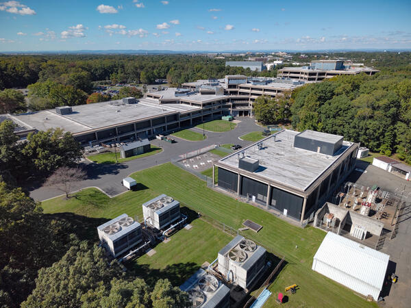
sUAS flights conducted over the Federal Center buildings in Reston, VA, on October 8, 2024, captured high-resolution imagery in preparation for the Federal Center's 50th-anniversary celebration.

Official websites use .gov
A .gov website belongs to an official government organization in the United States.
Secure .gov websites use HTTPS
A lock () or https:// means you’ve safely connected to the .gov website. Share sensitive information only on official, secure websites.
Woods Hole Coastal and Marine Science Center images
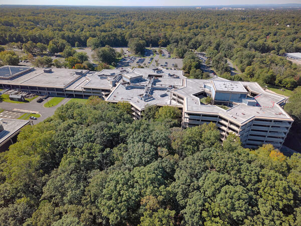
sUAS flights conducted over the Federal Center buildings in Reston, VA, on October 8, 2024, captured high-resolution imagery in preparation for the Federal Center's 50th-anniversary celebration.
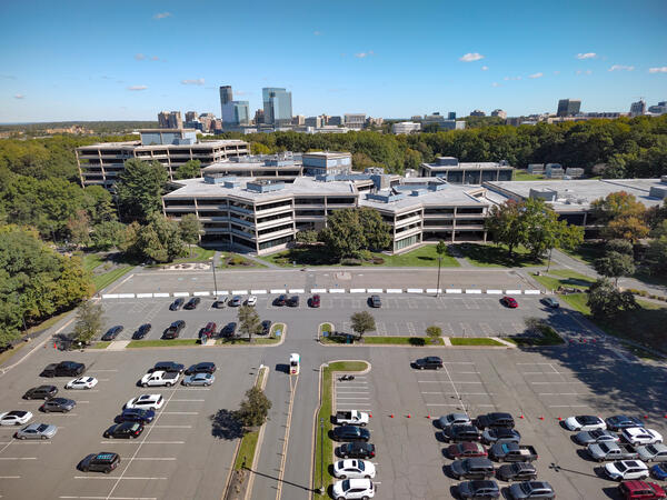
sUAS flights conducted over the Federal Center buildings in Reston, VA, on October 8, 2024, captured high-resolution imagery in preparation for the Federal Center's 50th-anniversary celebration.
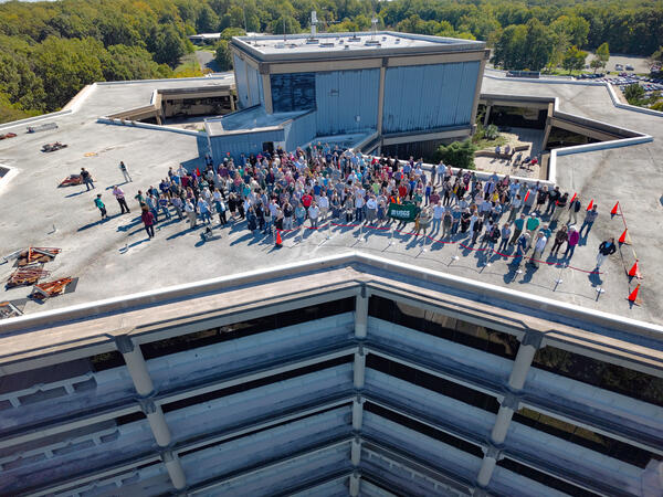
sUAS flights conducted over the Federal Center buildings in Reston, VA, on October 8, 2024, captured high-resolution imagery in preparation for the Federal Center's 50th-anniversary celebration.
sUAS flights conducted over the Federal Center buildings in Reston, VA, on October 8, 2024, captured high-resolution imagery in preparation for the Federal Center's 50th-anniversary celebration.
sUAS flights conducted over the Federal Center buildings in Reston, VA, on October 8, 2024, captured high-resolution imagery in preparation for the Federal Center's 50th-anniversary celebration.
sUAS flights conducted over the Federal Center buildings in Reston, VA, on October 8, 2024, captured high-resolution imagery in preparation for the Federal Center's 50th-anniversary celebration.
sUAS flights conducted over the Federal Center buildings in Reston, VA, on October 8, 2024, captured high-resolution imagery in preparation for the Federal Center's 50th-anniversary celebration.
sUAS flights conducted over the Federal Center buildings in Reston, VA, on October 8, 2024, captured high-resolution imagery in preparation for the Federal Center's 50th-anniversary celebration.

CoastCam on Madeira Beach in Florida on October 8, 2024 before Hurricane Milton made landfall on October 9, 2024.
CoastCam on Madeira Beach in Florida on October 8, 2024 before Hurricane Milton made landfall on October 9, 2024.

UAS Pilot Jennifer Cramer attaches a YellowScan Mapper+ lidar sensor to the underside of a DJI M600 in preparation to map the beach and marsh.
Town Neck Beach, Sandwich, Massachusetts
Fall 2024 Photo Contest Winner: Jin-Si Over, People category
UAS Pilot Jennifer Cramer attaches a YellowScan Mapper+ lidar sensor to the underside of a DJI M600 in preparation to map the beach and marsh.
Town Neck Beach, Sandwich, Massachusetts
Fall 2024 Photo Contest Winner: Jin-Si Over, People category

sUAS flights conducted over the Federal Center buildings in Reston, VA, on October 8, 2024, captured high-resolution imagery in preparation for the Federal Center's 50th-anniversary celebration.
sUAS flights conducted over the Federal Center buildings in Reston, VA, on October 8, 2024, captured high-resolution imagery in preparation for the Federal Center's 50th-anniversary celebration.

sUAS flights conducted over the Federal Center buildings in Reston, VA, on October 8, 2024, captured high-resolution imagery in preparation for the Federal Center's 50th-anniversary celebration.
sUAS flights conducted over the Federal Center buildings in Reston, VA, on October 8, 2024, captured high-resolution imagery in preparation for the Federal Center's 50th-anniversary celebration.

sUAS flights conducted over the Federal Center buildings in Reston, VA, on October 8, 2024, captured high-resolution imagery in preparation for the Federal Center's 50th-anniversary celebration.
sUAS flights conducted over the Federal Center buildings in Reston, VA, on October 8, 2024, captured high-resolution imagery in preparation for the Federal Center's 50th-anniversary celebration.

sUAS flights conducted over the Federal Center buildings in Reston, VA, on October 8, 2024, captured high-resolution imagery in preparation for the Federal Center's 50th-anniversary celebration.
sUAS flights conducted over the Federal Center buildings in Reston, VA, on October 8, 2024, captured high-resolution imagery in preparation for the Federal Center's 50th-anniversary celebration.

The Flood Event Viewer showing 12 meter high wave height data recorded by a SOFAR buoy during Hurricane Milton.
The Flood Event Viewer showing 12 meter high wave height data recorded by a SOFAR buoy during Hurricane Milton.
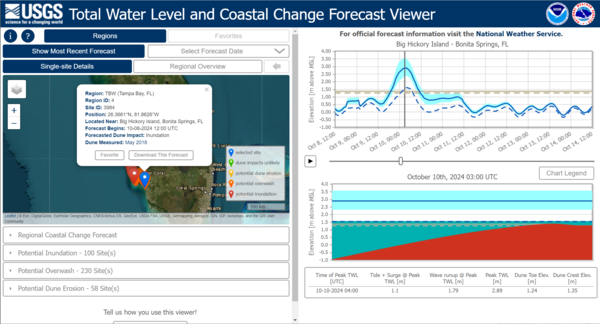
The Total Water Level and Coastal Change Forecast Viewer reflecting inundation data on the Gulf coast of Florida during Hurricane Milton.
The Total Water Level and Coastal Change Forecast Viewer reflecting inundation data on the Gulf coast of Florida during Hurricane Milton.
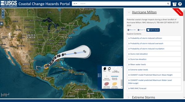
Coastal Change Hazards Portal showing the trajectory of Hurricane Milton and the various data users could explore on the map.
Coastal Change Hazards Portal showing the trajectory of Hurricane Milton and the various data users could explore on the map.
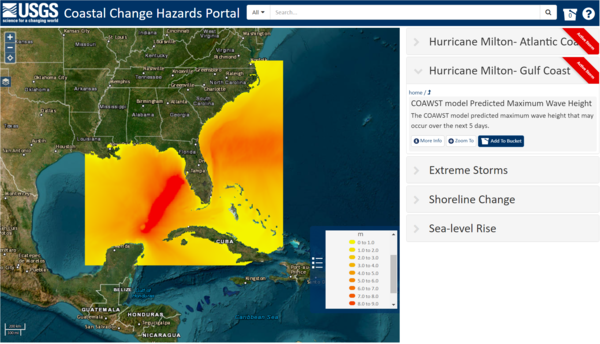
Coastal Change Hazards Portal showing maximum wave height and storm surge via the COAWST modeling system during Hurricane Milton.
Coastal Change Hazards Portal showing maximum wave height and storm surge via the COAWST modeling system during Hurricane Milton.
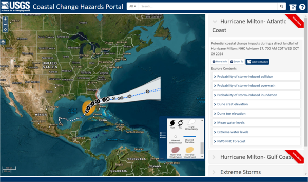
Coastal Change Hazards Portal showing the trajectory of Hurricane Milton and the various data users could explore on the map.
Coastal Change Hazards Portal showing the trajectory of Hurricane Milton and the various data users could explore on the map.
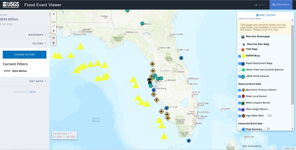
The Flood Event Viewer showing map data layers available during Hurricane Milton.
The Flood Event Viewer showing map data layers available during Hurricane Milton.
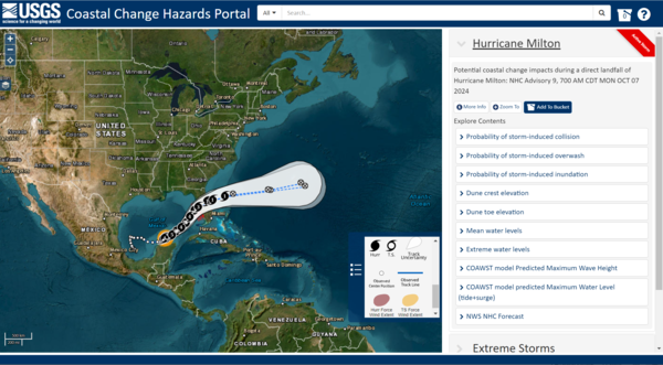
Coastal Change Hazards Portal showing the trajectory of Hurricane Milton and the various data users could explore on the map.
Coastal Change Hazards Portal showing the trajectory of Hurricane Milton and the various data users could explore on the map.

CoastCam on Madeira Beach in Florida showing coastal conditions during the approach of Hurricane Helene on September 26, 2024.
CoastCam on Madeira Beach in Florida showing coastal conditions during the approach of Hurricane Helene on September 26, 2024.
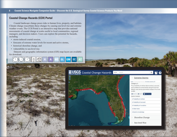
Coastal Change Hazards Portal page of the Coastal Science Navigator Companion Guide.
Coastal Change Hazards Portal page of the Coastal Science Navigator Companion Guide.
Screenshots from the Coastal Science Navigator Companion Guide overlaid on top of image of the Army Corps of Engineers Field Research Facility pier near Kitty Hawk, North Carolina.
Screenshots from the Coastal Science Navigator Companion Guide overlaid on top of image of the Army Corps of Engineers Field Research Facility pier near Kitty Hawk, North Carolina.

Chris Sherwood, Athina Lange, and Jin-Si Over look at a monitor hooked up to the CoastCams overlooking Marconi Beach on Cape Cod National Seashore. They are aligning the two stationary video cameras so there is a slight overlap in the look angle.
Chris Sherwood, Athina Lange, and Jin-Si Over look at a monitor hooked up to the CoastCams overlooking Marconi Beach on Cape Cod National Seashore. They are aligning the two stationary video cameras so there is a slight overlap in the look angle.