
An illustrated map displaying the HERA product coverage, in pink, for the U.S. West Coast and Pacific territories for Emergency Management. Coverage includes Guam, Mariana Islands, American Samoa,
Images
Woods Hole Coastal and Marine Science Center images
Filter Total Items: 1298
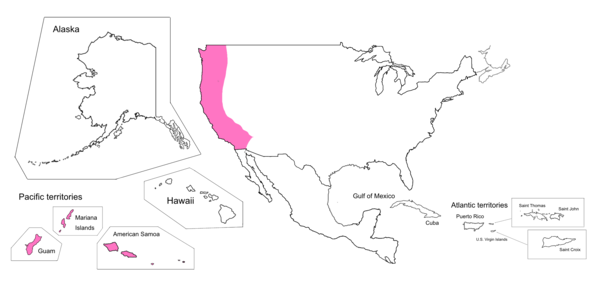
HERA Coverage Map
An illustrated map displaying the HERA product coverage, in pink, for the U.S. West Coast and Pacific territories for Emergency Management. Coverage includes Guam, Mariana Islands, American Samoa,

Total Water Level and Coastal Change Forecast Viewer Coverage Map
Total Water Level and Coastal Change Forecast Viewer Coverage MapIllustrated map displaying the coverage provided by the Total Water Level and Coastal Change Forecast Viewer for the U.S. East Coast and Gulf of America, in blue.
Total Water Level and Coastal Change Forecast Viewer Coverage Map
Total Water Level and Coastal Change Forecast Viewer Coverage MapIllustrated map displaying the coverage provided by the Total Water Level and Coastal Change Forecast Viewer for the U.S. East Coast and Gulf of America, in blue.

TSU Visit
On October 16 and 17, Ben Gutierrez visited Tennessee State University (TSU) to give guest lecture in Environmental Science and Water Resource classes taught by Tom Byl of the USGS Lower Mississippi Gulf Water Science Center.
On October 16 and 17, Ben Gutierrez visited Tennessee State University (TSU) to give guest lecture in Environmental Science and Water Resource classes taught by Tom Byl of the USGS Lower Mississippi Gulf Water Science Center.
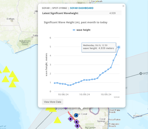
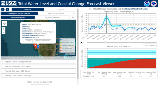
SOFAR Buoy Reading Water Height
SOFAR buoy of the western coast of Florida, within the expected track of Milton, actively transmitting real-time wave height. The graph reads a peak of above 4 meters. Captured October 9th 2024.
SOFAR buoy of the western coast of Florida, within the expected track of Milton, actively transmitting real-time wave height. The graph reads a peak of above 4 meters. Captured October 9th 2024.
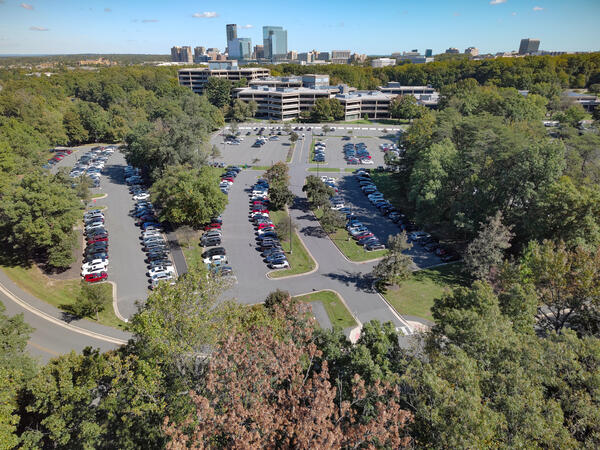
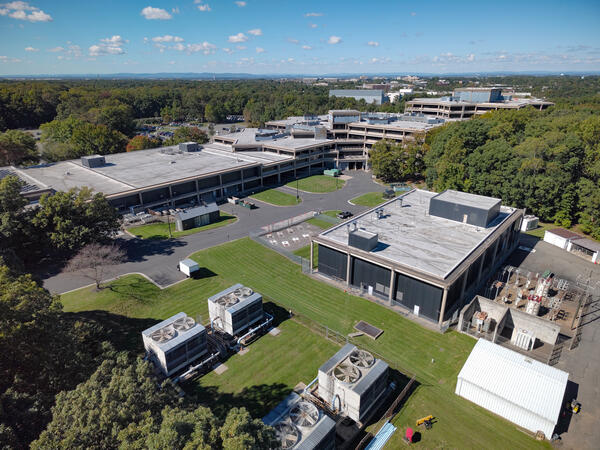
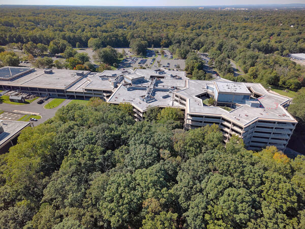
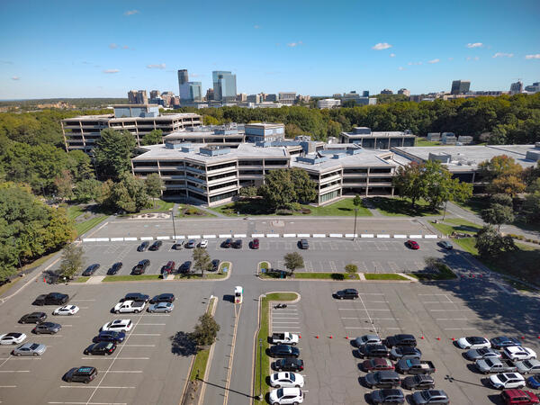
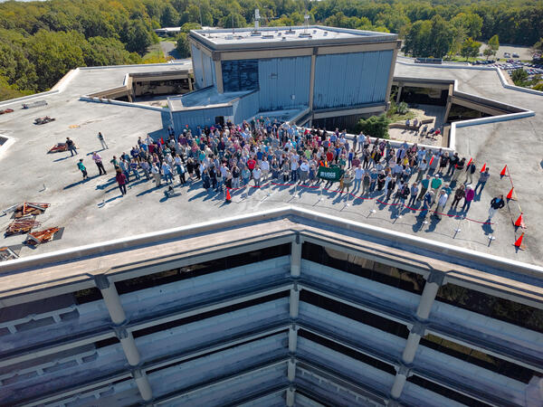
Federal Center buildings in Reston, VA
sUAS flights conducted over the Federal Center buildings in Reston, VA, on October 8, 2024, captured high-resolution imagery in preparation for the Federal Center's 50th-anniversary celebration.
sUAS flights conducted over the Federal Center buildings in Reston, VA, on October 8, 2024, captured high-resolution imagery in preparation for the Federal Center's 50th-anniversary celebration.

CoastCam - Hurricane Helene
CoastCam on Madeira Beach in Florida on October 8, 2024 before Hurricane Milton made landfall on October 9, 2024.
CoastCam on Madeira Beach in Florida on October 8, 2024 before Hurricane Milton made landfall on October 9, 2024.

UAS Pilot Jennifer Cramer attaches a YellowScan Mapper+ lidar sensor to the underside of a DJI M600 in preparation to map the beach and marsh
UAS Pilot Jennifer Cramer attaches a YellowScan Mapper+ lidar sensor to the underside of a DJI M600 in preparation to map the beach and marshUAS Pilot Jennifer Cramer attaches a YellowScan Mapper+ lidar sensor to the underside of a DJI M600 in preparation to map the beach and marsh.
Town Neck Beach, Sandwich, Massachusetts
Fall 2024 Photo Contest Winner: Jin-Si Over, People category

Federal Center buildings in Reston, VA
sUAS flights conducted over the Federal Center buildings in Reston, VA, on October 8, 2024, captured high-resolution imagery in preparation for the Federal Center's 50th-anniversary celebration.
sUAS flights conducted over the Federal Center buildings in Reston, VA, on October 8, 2024, captured high-resolution imagery in preparation for the Federal Center's 50th-anniversary celebration.

Flood Event Viewer - Hurricane Milton
The Flood Event Viewer showing 12 meter high wave height data recorded by a SOFAR buoy during Hurricane Milton.
The Flood Event Viewer showing 12 meter high wave height data recorded by a SOFAR buoy during Hurricane Milton.
TWL - Hurricane Milton
The Total Water Level and Coastal Change Forecast Viewer reflecting inundation data on the Gulf coast of Florida during Hurricane Milton.
The Total Water Level and Coastal Change Forecast Viewer reflecting inundation data on the Gulf coast of Florida during Hurricane Milton.
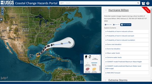
CCH Portal - Hurricane Milton
Coastal Change Hazards Portal showing the trajectory of Hurricane Milton and the various data users could explore on the map.
Coastal Change Hazards Portal showing the trajectory of Hurricane Milton and the various data users could explore on the map.
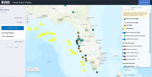
Flood Event Viewer - Hurricane Milton
The Flood Event Viewer showing map data layers available during Hurricane Milton.
The Flood Event Viewer showing map data layers available during Hurricane Milton.