
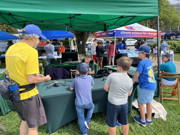
USGS Geographer Jin-Si Over talking about drones and how they are used to map short- and long-term changes in coastal environments at the Woods Hole Science Stroll.
Images
Woods Hole Coastal and Marine Science Center images
Filter Total Items: 1314

Woods Hole Science Stroll 2024
USGS Geographer Jin-Si Over talking about drones and how they are used to map short- and long-term changes in coastal environments at the Woods Hole Science Stroll.
Woods Hole Science Stroll 2024
USGS Geographer Jin-Si Over talking about drones and how they are used to map short- and long-term changes in coastal environments at the Woods Hole Science Stroll.
USGS Geographer Jin-Si Over talking about drones and how they are used to map short- and long-term changes in coastal environments at the Woods Hole Science Stroll.

Woods Hole Science Stroll 2024
USGS geographer Jin-Si Over at the 2024 Woods Hole Science Stroll, ready to discuss drones and how they are used to map short- and long-term changes in coastal environments.
USGS geographer Jin-Si Over at the 2024 Woods Hole Science Stroll, ready to discuss drones and how they are used to map short- and long-term changes in coastal environments.

Woods Hole Science Stroll 2024
USGS Geographer Jen Cramer showing off our uncrewed aircraft system technology at the Woods Hole Science Stroll.
USGS Geographer Jen Cramer showing off our uncrewed aircraft system technology at the Woods Hole Science Stroll.

Woods Hole Science Stroll 2024
USGS Geologist Marie Bartlett at the 2024 Woods Hole Science Stroll, ready for visitors to look at foraminifera, microfossils that live in marine environments, through our microscope.
USGS Geologist Marie Bartlett at the 2024 Woods Hole Science Stroll, ready for visitors to look at foraminifera, microfossils that live in marine environments, through our microscope.

Woods Hole Science Stroll 2024
Seth Ackerman (USGS Geologist) talking to a visitor at the USGS booth for the 2024 Woods Hole Science Stroll.
Seth Ackerman (USGS Geologist) talking to a visitor at the USGS booth for the 2024 Woods Hole Science Stroll.

Woods Hole Science Stroll 2024
USGS Geologist Marie Bartlett at the 2024 Woods Hole Science Stroll, ready for visitors to look at foraminifera, microfossils that live in marine environments, through our microscope.
USGS Geologist Marie Bartlett at the 2024 Woods Hole Science Stroll, ready for visitors to look at foraminifera, microfossils that live in marine environments, through our microscope.

Woods Hole Science Stroll 2024
USGS Geographer and drone pilot Jen Cramer showing visitors USGS uncrewed aircraft system technology and talking about how drones are used to map short- and long-term changes in coastal environments.
USGS Geographer and drone pilot Jen Cramer showing visitors USGS uncrewed aircraft system technology and talking about how drones are used to map short- and long-term changes in coastal environments.

Woods Hole Science Stroll 2024
USGS Geographer Jin-Si Over talking about drones and how they are used to map short- and long-term changes in coastal environments at the Woods Hole Science Stroll.
USGS Geographer Jin-Si Over talking about drones and how they are used to map short- and long-term changes in coastal environments at the Woods Hole Science Stroll.

Woods Hole Science Stroll 2024
Alfredo Aretxabaleta (USGS Research and Equipment Development Grade Evaluation (RGE-EDGE) Senior Scientist) showing off the jenga set at the Woods Hole Diversity Committee booth at the Woods Hole Science Stroll. They chose to have jenga at the booth to represent different people working together to keep the structure standing.
Alfredo Aretxabaleta (USGS Research and Equipment Development Grade Evaluation (RGE-EDGE) Senior Scientist) showing off the jenga set at the Woods Hole Diversity Committee booth at the Woods Hole Science Stroll. They chose to have jenga at the booth to represent different people working together to keep the structure standing.

Woods Hole Science Stroll 2024
The Woods Hole Diversity Advisory Committee booth at the 2024 Woods Hole Science Stroll.
The Woods Hole Diversity Advisory Committee booth at the 2024 Woods Hole Science Stroll.

Woods Hole Science Stroll 2024
Chris Polloni, a retired scientist who had a long career with USGS, with Kate and Seth Ackerman at the Woods Hole Science Stroll. Chris was known to always have a coffee mug in his hand and today was no different!
Chris Polloni, a retired scientist who had a long career with USGS, with Kate and Seth Ackerman at the Woods Hole Science Stroll. Chris was known to always have a coffee mug in his hand and today was no different!

Woods Hole Science Stroll 2024
USGS Geographer Jin-Si Over at the 2024 Woods Hole Science Stroll holding one of our drones.
USGS Geographer Jin-Si Over at the 2024 Woods Hole Science Stroll holding one of our drones.

Puerto Rico beach
Scenic photo of Domes Beach in Rincon, Puerto Rico. Photo credit: Emily Himmelstoss.
Scenic photo of Domes Beach in Rincon, Puerto Rico. Photo credit: Emily Himmelstoss.

Mapping Nantucket Sound
USGS Marine Operations Manager Chuck Worley conducting fieldwork to study the geologic framework of Nantucket Sound.
USGS Marine Operations Manager Chuck Worley conducting fieldwork to study the geologic framework of Nantucket Sound.

U.S. Coastal Wetland Synthesis Applications Webpage Image
U.S. Coastal Wetland Synthesis Applications Webpage ImageThe USGS is assessing the physical condition of coastal wetlands and their response to external forces, using field observations and remote-sensing data. The U.S.
U.S. Coastal Wetland Synthesis Applications Webpage Image
U.S. Coastal Wetland Synthesis Applications Webpage ImageThe USGS is assessing the physical condition of coastal wetlands and their response to external forces, using field observations and remote-sensing data. The U.S.

Distinguished Service Award - Carolyn Ruppel
Distinguished Service Award for USGS Research Geophysicist Carolyn Ruppel, presented on May 8, 2024.
Distinguished Service Award for USGS Research Geophysicist Carolyn Ruppel, presented on May 8, 2024.
Collecting Shoreline and Volumetric Data
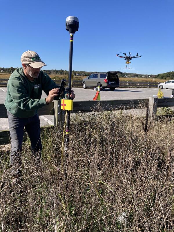
From June through December, WHCMSC scientists are collecting shoreline and volumetric data at a beach in Sandwich, Massachusetts following a 2023 U.S. Army Corps of Engineers beach nourishment. The data will be useful for various purposes. Chris Sherwood is interested in comparing how the different measuring techniques work on different types of vegetation.
From June through December, WHCMSC scientists are collecting shoreline and volumetric data at a beach in Sandwich, Massachusetts following a 2023 U.S. Army Corps of Engineers beach nourishment. The data will be useful for various purposes. Chris Sherwood is interested in comparing how the different measuring techniques work on different types of vegetation.

Ernest F. Hollings ACE Basin National Wildlife Refuge
Ernest F. Hollings ACE Basin National Wildlife RefugeErnest F. Hollings ACE Basin National Wildlife Refuge in South Carolina shown in the pop-out of the U.S. Coastal Wetlands Synthesis Applications geonarrative.
Ernest F. Hollings ACE Basin National Wildlife Refuge
Ernest F. Hollings ACE Basin National Wildlife RefugeErnest F. Hollings ACE Basin National Wildlife Refuge in South Carolina shown in the pop-out of the U.S. Coastal Wetlands Synthesis Applications geonarrative.

Ernest F. Hollings ACE Basin National Wildlife Refuge
Ernest F. Hollings ACE Basin National Wildlife RefugeErnest F. Hollings ACE Basin National Wildlife Refuge in South Carolina shown in the pop-out of the U.S. Coastal Wetlands Synthesis Applications geonarrative.
Ernest F. Hollings ACE Basin National Wildlife Refuge
Ernest F. Hollings ACE Basin National Wildlife RefugeErnest F. Hollings ACE Basin National Wildlife Refuge in South Carolina shown in the pop-out of the U.S. Coastal Wetlands Synthesis Applications geonarrative.

Southeast Region Refuges
The Southeast Region Refuges tab of the U.S. Coastal Wetlands Synthesis Applications geonarrative. A FWS and USGS collaboration.
The Southeast Region Refuges tab of the U.S. Coastal Wetlands Synthesis Applications geonarrative. A FWS and USGS collaboration.