
Global Seabed Mineral Resources
Providing stakeholders with best available science regarding potential resources and environmental impacts associated with accessing those resources
Providing stakeholders with best available science regarding potential resources and environmental impacts associated with accessing those resources
Major Update to Satellite-Based Datasets Used to Assess Salt Marsh Vulnerability Nationwide
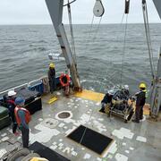
Seafloor Seismographs Rapidly Deployed Following Major Earthquake Offshore Northern California
Coral reef restoration
Cost-benefit study confirms coral reef restoration could be a cost-effective way to save lives and money
Cost-benefit study confirms coral reef restoration could be a cost-effective way to save lives and money
Ocean
USGS science improves our understanding of ocean processes, marine resources and submarine geohazards.
USGS science improves our understanding of ocean processes, marine resources and submarine geohazards.
Coasts
USGS provides critical science that informs risk reduction, protecting people, businesses, infrastructure, and resources along our coastlines, where 40% of our population lives.
USGS provides critical science that informs risk reduction, protecting people, businesses, infrastructure, and resources along our coastlines, where 40% of our population lives.
Meet the Coastal Science Navigator
Learn more about this new product to help you find useful USGS coastal data and tools
Learn more about this new product to help you find useful USGS coastal data and tools
Coastal and Marine Hazards and Resources Program
Scientists and staff study coastal and ocean processes, from shorelines to the deep sea, to identify hazards and provide critical information on our nation's resources. This work supports preparedness, emergency response, and the protection of people and resources in coastal and ocean environments.
Sound Waves Newsletter
Sound Waves Newsletter

Coastal and marine news from across the U.S. Geological Survey

News
Explore Global Coastal Research Using the COAWST Applications Catalog
Explore Global Coastal Research Using the COAWST Applications Catalog
USGS Releases Expedition Report for Samoa Basin Box Coring Effort
USGS Releases Expedition Report for Samoa Basin Box Coring Effort
USGS Coastal Change Products Help the EPA Safeguard Long Island Sound Shorelines
USGS Coastal Change Products Help the EPA Safeguard Long Island Sound Shorelines
Publications
Improving offshore 3D splay fault geometries and slip histories using seismic data reprocessing and structural modeling Improving offshore 3D splay fault geometries and slip histories using seismic data reprocessing and structural modeling
The goal of this project as written in the CRESCENT seed grant proposal was as follows: 1) reprocess selected profiles along strike from 45° to 48°N from the CASIE21 crustal-scale seismic data to obtain higher-resolution and higher-quality imaging of the uppermost 1-2 km of the accretionary wedge; 2) convert high-resolution USGS sparker seismic data from the time to depth domain to...
Storm surge barriers reduce seaward sediment supply to lagoonal estuaries Storm surge barriers reduce seaward sediment supply to lagoonal estuaries
Numerical simulations with realistic forcing of fixed infrastructure for a proposed storm surge barrier for a lagoonal estuary, Jamaica Bay (New York, USA), are analyzed during typical forcing conditions to assess alterations to flow and sediment transport with the barrier open. Lagoonal estuaries are shallow and have modest watershed freshwater and sediment inputs, so sediment delivery...
Acoustic measurements and modeling of sub-bottom layers on the summit of the Atlantis II Seamount Acoustic measurements and modeling of sub-bottom layers on the summit of the Atlantis II Seamount
Sub-bottom profiler images taken from the summit plateau of the Atlantis II Seamount reveal distinct seabed stratigraphy, including marine sediment, limestone, and basalt layers. Acoustic reflection data also show arrivals reflecting from this sub-bottom structure. A wavenumber integration model with elastic geoacoustic properties is able to reproduce the arrival pattern of seabed...
Science

COAWST: A Coupled-Ocean-Atmosphere-Wave-Sediment Transport Modeling System
Understanding the processes responsible for coastal change is important for managing both our natural and economic coastal resources. Storms are one of the primary driving forces causing coastal change from a coupling of wave- and wind-driven flows. To better understand storm impacts and their effects on our coastlines, there is an international need to better predict storm paths and intensities...
Coastal and Marine Science in Long Island Sound
Long Island Sound is a highly productive estuary and vital natural resource bordering New York and Connecticut. It’s essential for its massive economic impact, generating billions annually by supporting recreation, fisheries, and transportation, as well as its biodiversity, serving as a critical habitat for thousands of marine species. USGS research in Long Island Sound helps protect these...
National Shoreline Change Data Publication Catalog
The U.S. Geological Survey (USGS) maintains shoreline positions for the United States from older sources, such as aerial photos and topographic surveys, and contemporary sources like digital elevation models (DEMs) and lidar elevation point cloud data. It's important to maintain, and make available, records of historical shoreline positions to allow monitoring of change over time, and to identify...