
On January 14, 2015, hydrologic technicians Jeff Kinsey (shown) and Nick Stasulis visited USGS gaging station 01030500 on the Mattawamkeag River.
Images
Images
Filter Total Items: 9454

Winter Morning Streamgaging
On January 14, 2015, hydrologic technicians Jeff Kinsey (shown) and Nick Stasulis visited USGS gaging station 01030500 on the Mattawamkeag River.
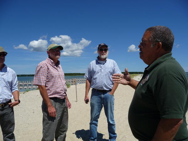
Hurricane Sandy Mashpee Tribe Visit

Michelle Collier of the USGS holding a black and white Tegu
Michelle Collier of the USGS holding a black and white TeguInvasive Species biological science technician Michelle Collier holds an invasive black and white Tegu lizard.
Michelle Collier of the USGS holding a black and white Tegu
Michelle Collier of the USGS holding a black and white TeguInvasive Species biological science technician Michelle Collier holds an invasive black and white Tegu lizard.

Chesapeake Bay Landsat mosaic 2014
Chesapeake Bay and surroundings, mosaic of 5 Landsat images taken in October and November 2014.
Chesapeake Bay and surroundings, mosaic of 5 Landsat images taken in October and November 2014.

American Bullfrog
An American bullfrog along the Yellowstone River near Billings, MT.
An American bullfrog along the Yellowstone River near Billings, MT.

A mangy wolf in Yellowstone National Park.

Neuston net
Collecting a microplastics sample using a neuston net, Milwaukee River, Milwaukee, Wisconsin.
Collecting a microplastics sample using a neuston net, Milwaukee River, Milwaukee, Wisconsin.

Garden Wall Weather Station, MT
The Garden Wall Weather Station is situated below the Garden Wall and adjacent to the Haystack Creek avalanche path in Glacier National Park. It provides meteorological data for avalanche forecasting and research, including wind speed and direction, air temperature, relative humidity, and net radiation measurements.
The Garden Wall Weather Station is situated below the Garden Wall and adjacent to the Haystack Creek avalanche path in Glacier National Park. It provides meteorological data for avalanche forecasting and research, including wind speed and direction, air temperature, relative humidity, and net radiation measurements.

3DEP, lidar acquisition
Sample graphic of airborne lidar data acquisition. Target area is illuminated by pulsed laser light in the aircraft, Differences in laser return times and wavelengths are then used to make digital 3D representations of the selected ground sections.
Sample graphic of airborne lidar data acquisition. Target area is illuminated by pulsed laser light in the aircraft, Differences in laser return times and wavelengths are then used to make digital 3D representations of the selected ground sections.

3DEP, lidar point cloud, Denver
A 3D Elevation Program lidar point cloud showing simulated flooding (in blue) of an area in Denver, Colorado
A 3D Elevation Program lidar point cloud showing simulated flooding (in blue) of an area in Denver, Colorado

Microplastics in Jar
Microplastics, organic material, and other debris in a sample from the Milwaukee River, Milwaukee, Wisconsin.
Microplastics, organic material, and other debris in a sample from the Milwaukee River, Milwaukee, Wisconsin.

Sampling a private well in Lycoming County, Pennsylvania
Sampling a private well in Lycoming County, PennsylvaniaBrian Selck, a USGS National Association of Geoscience Teachers intern, collects a water level measurement from a domestic well at a site north of Jersey Shore in Lycoming County, Pennsylvania, June 2014.

Little Plover River Wells
Both irrigation wells and municipal wells affect water levels in the Little Plover River, Wisconsin.
Both irrigation wells and municipal wells affect water levels in the Little Plover River, Wisconsin.

Surveying Bullfrogs
USGS biologists surveying for bullfrogs at Two Moon Park, Billings, MT.
USGS biologists surveying for bullfrogs at Two Moon Park, Billings, MT.

Collecting microplastic samples
USGS scientists Pete Lenaker and Nic Buer collect a microplastic sample at the Manitowoc River, Manitowoc, Wisconsin.
USGS scientists Pete Lenaker and Nic Buer collect a microplastic sample at the Manitowoc River, Manitowoc, Wisconsin.

Oso landslide, 3DEP
Aerial photo of the Oso, Washington landslide in 2014. The red arrows show the direction of material flow. The inset lidar image was derived from 3DEP data collected by the Washington Department of Transportation.
Aerial photo of the Oso, Washington landslide in 2014. The red arrows show the direction of material flow. The inset lidar image was derived from 3DEP data collected by the Washington Department of Transportation.

Green Tree Frog
This green tree frog (Hyla cinerea) sits on the lip of a pitcher plant in a bog in Alabama. The frog was down in the pitcher plant, but moved up to rest on its edge as the photographer approached.
This green tree frog (Hyla cinerea) sits on the lip of a pitcher plant in a bog in Alabama. The frog was down in the pitcher plant, but moved up to rest on its edge as the photographer approached.

Transporting a Captured Mule Deer
Researchers with the University of Wyoming and the Wyoming Game and Fish Department transport a captured a mule deer in the Wyoming Range of Wyoming. The deer was fitted with a GPS tracking and its body fat was assesssed and other biolgogical samples taken before release.
Researchers with the University of Wyoming and the Wyoming Game and Fish Department transport a captured a mule deer in the Wyoming Range of Wyoming. The deer was fitted with a GPS tracking and its body fat was assesssed and other biolgogical samples taken before release.
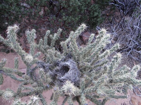
Bird's Nest in Cactus
A bird's nest in a cholla cactus in Pine Creek Canyon. The bird is likely a cactus wren, a species that nests specifically in cacti.
Pine Creek Canyon is a remnant ecosystem of loblolly pines. A remnant ecosystem is the last vestige of an ecosystem type that used to be more widespred.
A bird's nest in a cholla cactus in Pine Creek Canyon. The bird is likely a cactus wren, a species that nests specifically in cacti.
Pine Creek Canyon is a remnant ecosystem of loblolly pines. A remnant ecosystem is the last vestige of an ecosystem type that used to be more widespred.

Yucca in Pine Creek Canyon
Pine Creek Canyon is a remnant ecosystem of loblolly pines. A remnant ecosystem is the last vestige of an ecosystem type that used to be more widespred.
Red Rock Canyon is a National Conservation Area managed by the Bureau of Land Management, located just outside of Las Vegas, Nevada. It is part of the Mojave Desert.

Lichen on Sandstone
Lichen on sandstone in Pine Creek Canyon. Lichen is a composite organism made up of algae and fungi, which form a symbiotic relationship.
Pine Creek Canyon is a remnant ecosystem of loblolly pines. A remnant ecosystem is the last vestige of an ecosystem type that used to be more widespred.
Lichen on sandstone in Pine Creek Canyon. Lichen is a composite organism made up of algae and fungi, which form a symbiotic relationship.
Pine Creek Canyon is a remnant ecosystem of loblolly pines. A remnant ecosystem is the last vestige of an ecosystem type that used to be more widespred.