Canyonlands National Park was one of four national parks established (1964) under the leadership of Interior Secretary Stewart Udall.
Landsat 8, acquired March 29, 2015.

Official websites use .gov
A .gov website belongs to an official government organization in the United States.
Secure .gov websites use HTTPS
A lock () or https:// means you’ve safely connected to the .gov website. Share sensitive information only on official, secure websites.
Images

Canyonlands National Park was one of four national parks established (1964) under the leadership of Interior Secretary Stewart Udall.
Landsat 8, acquired March 29, 2015.
Canyonlands National Park was one of four national parks established (1964) under the leadership of Interior Secretary Stewart Udall.
Landsat 8, acquired March 29, 2015.

A juvenile Broad-banded Watersnake that tested positive for snake fungal disease (SFD) exhibiting several crusty ventral scales from St. Martin Parish, Louisiana. SFD has proven lethal in many snakes, and the disease is recognized as an emerging threat to wild snake populations.
A juvenile Broad-banded Watersnake that tested positive for snake fungal disease (SFD) exhibiting several crusty ventral scales from St. Martin Parish, Louisiana. SFD has proven lethal in many snakes, and the disease is recognized as an emerging threat to wild snake populations.

A juvenile Broad-banded Watersnake that tested positive for snake fungal disease (SFD) exhibiting numerous nodules overlaid by roughened skin on the dorsal surface from St. Martin Parish, Louisiana. "FD has proven lethal in many snakes, and the disease is recognized as an emerging threat to wild snake populations.
A juvenile Broad-banded Watersnake that tested positive for snake fungal disease (SFD) exhibiting numerous nodules overlaid by roughened skin on the dorsal surface from St. Martin Parish, Louisiana. "FD has proven lethal in many snakes, and the disease is recognized as an emerging threat to wild snake populations.

A juvenile Broad-banded Watersnake that tested positive for snake fungal disease (SFD) exhibiting numerous nodules overlaid by roughened skin on the dorsal surface from St. Martin Parish, Louisiana. SFD has proven lethal in many snakes, and the disease is recognized as an emerging threat to wild snake populations.
A juvenile Broad-banded Watersnake that tested positive for snake fungal disease (SFD) exhibiting numerous nodules overlaid by roughened skin on the dorsal surface from St. Martin Parish, Louisiana. SFD has proven lethal in many snakes, and the disease is recognized as an emerging threat to wild snake populations.

A juvenile Broad-banded Watersnake that tested positive for snake fungal disease (SFD) exhibiting ulceration of the skin on the head from St. Martin Parish, Louisiana. SFD has proven lethal in many snakes, and the disease is recognized as an emerging threat to wild snake populations.
A juvenile Broad-banded Watersnake that tested positive for snake fungal disease (SFD) exhibiting ulceration of the skin on the head from St. Martin Parish, Louisiana. SFD has proven lethal in many snakes, and the disease is recognized as an emerging threat to wild snake populations.

San Jose Earthquakes' Avaya Stadium.

A USGS streamgage measures flooding in the lower Trinity River, Texas.
A USGS streamgage measures flooding in the lower Trinity River, Texas.

Re-vegetation in the river valley at the Elwha River restoration site. Image available at Olympic National Park flickr site.
Re-vegetation in the river valley at the Elwha River restoration site. Image available at Olympic National Park flickr site.
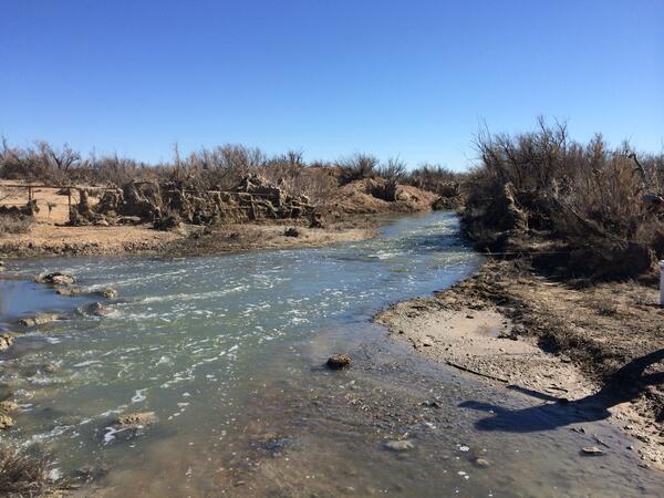
Pecos River at Old Crane Road bridge, Texas, downstream view. Photograph by Christopher Braun, U.S. Geological Survey, February 2015.
SIR 2019-5071
Pecos River at Old Crane Road bridge, Texas, downstream view. Photograph by Christopher Braun, U.S. Geological Survey, February 2015.
SIR 2019-5071
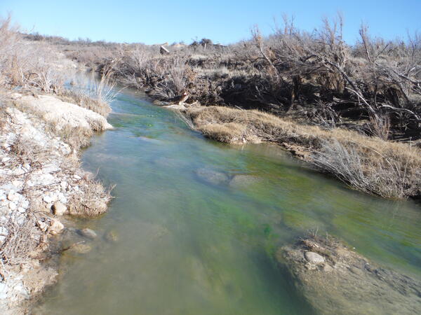
Pecos River near Malaga, New Mexico, downstream view. Photograph by Daniel Sinclair, U.S. Geological Survey, February 2015.
SIR 2019-5071
Pecos River near Malaga, New Mexico, downstream view. Photograph by Daniel Sinclair, U.S. Geological Survey, February 2015.
SIR 2019-5071

Hydrologist Charlie Culbertson holds an acoustic velocity meter under the ice covered river while standing under the covered bridge over the Ellis River at South Andover, Maine. This meter is used to collect streamflow information through the ice during the winter period.
Hydrologist Charlie Culbertson holds an acoustic velocity meter under the ice covered river while standing under the covered bridge over the Ellis River at South Andover, Maine. This meter is used to collect streamflow information through the ice during the winter period.
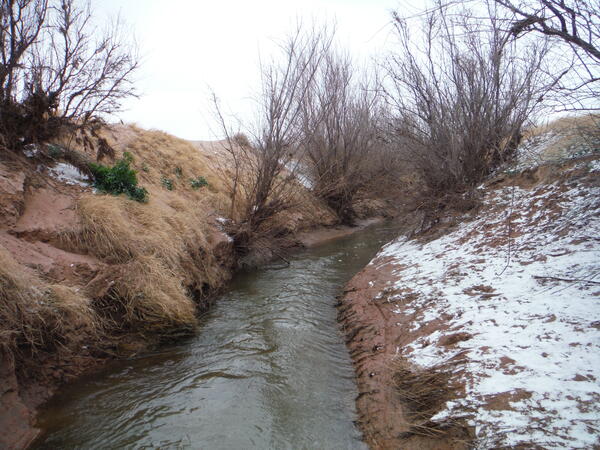
Bitter Lake National Wildlife Refuge south weir inflow, New Mexico, downstream view. Photograph by Daniel Sinclair, U.S. Geological Survey, February 2015.
SIR
Bitter Lake National Wildlife Refuge south weir inflow, New Mexico, downstream view. Photograph by Daniel Sinclair, U.S. Geological Survey, February 2015.
SIR

A brain coral boulder eight feet in diameter stands 750 feet inland in the British Virgin Islands. Geologists say that the coral was brought ashore, probably alive, by an unusual tsunami or storm between the years 1200 and 1480.
A brain coral boulder eight feet in diameter stands 750 feet inland in the British Virgin Islands. Geologists say that the coral was brought ashore, probably alive, by an unusual tsunami or storm between the years 1200 and 1480.

Tatqiq, an adult female polar bear at the San Diego Zoo, wearing an accelerometer collar being used to develop a method to remotely identify wild polar bear behaviors.
Tatqiq, an adult female polar bear at the San Diego Zoo, wearing an accelerometer collar being used to develop a method to remotely identify wild polar bear behaviors.

Black-footed albatross with chick, nesting black-footed albatrosses are especially vulnerable to sea-level rise and sudden flooding on low-lying islands.
Location: Midway Atoll National Wildlife Refuge
Black-footed albatross with chick, nesting black-footed albatrosses are especially vulnerable to sea-level rise and sudden flooding on low-lying islands.
Location: Midway Atoll National Wildlife Refuge

Tatqiq, an adult female polar bear at the San Diego Zoo, wearing an accelerometer collar being used to develop a method to remotely identify wild polar bear behaviors.
Tatqiq, an adult female polar bear at the San Diego Zoo, wearing an accelerometer collar being used to develop a method to remotely identify wild polar bear behaviors.

A U.S. Geological Survey hydrologist holds a centrifuge bowl containing river suspended sediment for analysis of metals and organic chemicals. The sample was collected using a new in-field continuous-flow centrifugation technique to separate and collect suspended sediment from large volumes of water.
A U.S. Geological Survey hydrologist holds a centrifuge bowl containing river suspended sediment for analysis of metals and organic chemicals. The sample was collected using a new in-field continuous-flow centrifugation technique to separate and collect suspended sediment from large volumes of water.

Frac sands courtesy of Unimin Energy Solutions.
Frac sands courtesy of Unimin Energy Solutions.

Frac sands courtesy of Unimin Energy Solutions.
Frac sands courtesy of Unimin Energy Solutions.
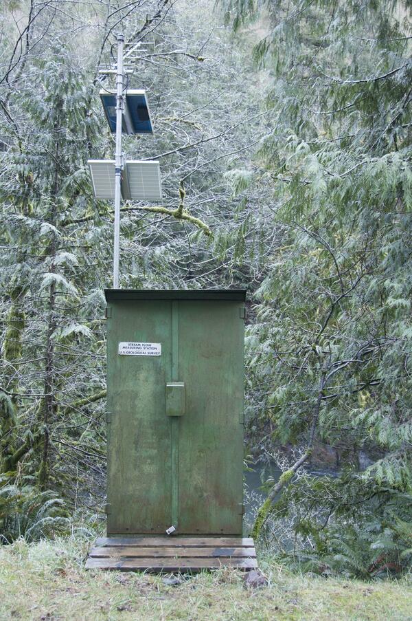
A U.S. Geological Survey streamflow gaging station collects water data on the Trask River. The Trask River gage is located near Tillamook, Ore. and has been in operation for 17 years.
A U.S. Geological Survey streamflow gaging station collects water data on the Trask River. The Trask River gage is located near Tillamook, Ore. and has been in operation for 17 years.

Trask River stage, discharge, and water-quality data are collected and used together to help monitor the current health of the river. Data from the river are sent to equipment in the gage house, where it is stored then transmitted to USGS servers.
Trask River stage, discharge, and water-quality data are collected and used together to help monitor the current health of the river. Data from the river are sent to equipment in the gage house, where it is stored then transmitted to USGS servers.