
In this image, the Moon may be seen in panorama rising over Half Dome. Half Dome is a granite dome, rising about 4,737 ft (1,444 m) above the surrounding valley. It is part of the Sierra Nevada batholith and is one of Yosemite National Park's most famous features.
Images
Images
Filter Total Items: 9448

Moon over Half Dome Panorama
In this image, the Moon may be seen in panorama rising over Half Dome. Half Dome is a granite dome, rising about 4,737 ft (1,444 m) above the surrounding valley. It is part of the Sierra Nevada batholith and is one of Yosemite National Park's most famous features.
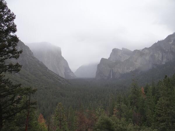
Yosemite Valley in Fog
In this image, Yosemite Valley may be seen shrouded in fog from Tunnel View. Yosemite Valley is a glacially carved valley located within Yosemite National Park. It is part of the Sierra Nevada batholith and is largely composed of granite.
In this image, Yosemite Valley may be seen shrouded in fog from Tunnel View. Yosemite Valley is a glacially carved valley located within Yosemite National Park. It is part of the Sierra Nevada batholith and is largely composed of granite.
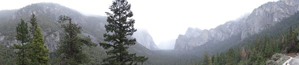
Yosemite Valley in Fog Panorama
In this image, Yosemite Valley may be seen shrouded in fog from Tunnel View. Yosemite Valley is a glacially carved valley located within Yosemite National Park. It is part of the Sierra Nevada batholith and is largely composed of granite.
In this image, Yosemite Valley may be seen shrouded in fog from Tunnel View. Yosemite Valley is a glacially carved valley located within Yosemite National Park. It is part of the Sierra Nevada batholith and is largely composed of granite.

Ice Jams
Ice Jams in Powder River at Arvada, WY, downstream of the bridge.
Ice Jams in Powder River at Arvada, WY, downstream of the bridge.
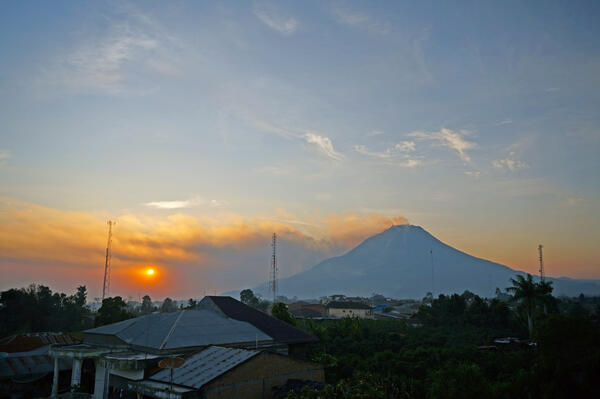
Sinabung Volcano
Sinabung volcano in Indonesia with a volcanic plume obscuring the sun on March 4, 2014. Photograph credit: Jeff Marso, USGS
Sinabung volcano in Indonesia with a volcanic plume obscuring the sun on March 4, 2014. Photograph credit: Jeff Marso, USGS

Carolina Northern Flying Squirrel
Radio-collared female Carolina Northern Flying Squirrel (Glaucomys sabrinus coloratus) in a high elevation red spruce (Picea rubens) stand on Whitetop Mountain, VA during winter of 2014.
Radio-collared female Carolina Northern Flying Squirrel (Glaucomys sabrinus coloratus) in a high elevation red spruce (Picea rubens) stand on Whitetop Mountain, VA during winter of 2014.

Wave-driven flooding and overwash on Roi-Namur Atoll
Wave-driven flooding and overwash on Roi-Namur AtollWave-driven flooding and overwash on Roi-Namur Atoll, Republic of the Marshall Islands
Wave-driven flooding and overwash on Roi-Namur Atoll
Wave-driven flooding and overwash on Roi-Namur AtollWave-driven flooding and overwash on Roi-Namur Atoll, Republic of the Marshall Islands

Wave-driven flooding and overwash on Roi-Namur Atoll
Wave-driven flooding and overwash on Roi-Namur AtollWave-driven flooding and overwash on Roi-Namur Atoll, Republic of the Marshall Islands
Wave-driven flooding and overwash on Roi-Namur Atoll
Wave-driven flooding and overwash on Roi-Namur AtollWave-driven flooding and overwash on Roi-Namur Atoll, Republic of the Marshall Islands

Winter Hydrographer
Robert Bradley, a hydrologic technician with the Massachusetts USGS Office, headed to Maine to experience a winter ice measurement trip with Laura Flight, a hydrologic technician from the Maine USGS Office.
Robert Bradley, a hydrologic technician with the Massachusetts USGS Office, headed to Maine to experience a winter ice measurement trip with Laura Flight, a hydrologic technician from the Maine USGS Office.

Measuring Snow Water Content
USGS hydrologic technician Jim Caldwell uses an aluminum tube and scale to measure snow depth, snow water content and snow density as part of the Maine Cooperative Snow Survey. This survey is conducted throughout Maine in the spring to aid in the evaluation of flood potential by the Maine River Flow Advisory Commission.
USGS hydrologic technician Jim Caldwell uses an aluminum tube and scale to measure snow depth, snow water content and snow density as part of the Maine Cooperative Snow Survey. This survey is conducted throughout Maine in the spring to aid in the evaluation of flood potential by the Maine River Flow Advisory Commission.

USGS scientists collect time-domain electromagnetic sounding
USGS scientists collect time-domain electromagnetic soundingUSGS scientists collect time-domain electromagnetic sounding in the Texas southern highplains to measure hydrogeologic properties below the land surface.
USGS scientists collect time-domain electromagnetic sounding
USGS scientists collect time-domain electromagnetic soundingUSGS scientists collect time-domain electromagnetic sounding in the Texas southern highplains to measure hydrogeologic properties below the land surface.

Rio Grande near Radium Springs, New Mexico
South-oriented view of the Rio Grande near Radium Springs, New Mexico, February 4, 2014 (photograph by Andrew J. Robertson).
SIR 2016–5010
South-oriented view of the Rio Grande near Radium Springs, New Mexico, February 4, 2014 (photograph by Andrew J. Robertson).
SIR 2016–5010

Hydrographer on the Ice
Scott Bendtson, a hydrologic technician with the Maine Office of the New England Water Science Center, is seen here making a discharge measurement through the ice on the St. John River at Ninemile Bridge, USGS station number 01010000.
Scott Bendtson, a hydrologic technician with the Maine Office of the New England Water Science Center, is seen here making a discharge measurement through the ice on the St. John River at Ninemile Bridge, USGS station number 01010000.

Winter Wading Measurement
Nick Stasulis, a hydrologic technician with the Maine Office of the New England Water Science Center, is seen here making a wading discharge measurement on the East Branch Wesserunsett Stream near Athens, USGS station number 01048220.
Nick Stasulis, a hydrologic technician with the Maine Office of the New England Water Science Center, is seen here making a wading discharge measurement on the East Branch Wesserunsett Stream near Athens, USGS station number 01048220.

Layered Ice
An ice jam on the East Branch Wesserunsett Stream in Athens, Maine in January 2014 left 3-5 ft ice walls on the riverbanks. On a January 21, 2014 site visit Nick Stasulis and Charlie Culbertson chisled away some of the ice wall so a discharge measurement could be made.
An ice jam on the East Branch Wesserunsett Stream in Athens, Maine in January 2014 left 3-5 ft ice walls on the riverbanks. On a January 21, 2014 site visit Nick Stasulis and Charlie Culbertson chisled away some of the ice wall so a discharge measurement could be made.

Mount Rainier looms over the Puyallup Valley, Washington
Mount Rainier looms over the Puyallup Valley, WashingtonMount Rainier volcano looms over Puyallup Valley, near Orting, Washington.
Mount Rainier looms over the Puyallup Valley, Washington
Mount Rainier looms over the Puyallup Valley, WashingtonMount Rainier volcano looms over Puyallup Valley, near Orting, Washington.

Mount Rainier Looms over the Puyallup Valley, Washington
Mount Rainier Looms over the Puyallup Valley, WashingtonMount Rainier volcano looms over Puyallup Valley, near Orting, Washington.
Mount Rainier Looms over the Puyallup Valley, Washington
Mount Rainier Looms over the Puyallup Valley, WashingtonMount Rainier volcano looms over Puyallup Valley, near Orting, Washington.

Measuring Stream Discharge in Grand Teton National Park
Measuring Stream Discharge in Grand Teton National ParkUSGS hydrologic technician Bob Reaves collects streamflow measurements from the cableway at the USGS streamgage on the Snake River near Moran, WY. Jackson Lake Dam is shown in the background. Location: USGS streamgage station 13011000, Snake River near Moran, WY, Grand Teton National Park.

Bituminous Coal
This sample is of bituminous coal, a middle rank coal (between subbituminous and anthracite) formed by additional pressure and heat on lignite.
This sample is of bituminous coal, a middle rank coal (between subbituminous and anthracite) formed by additional pressure and heat on lignite.

Peat
Peat is the precursor to coal. It's made up of decayed plant materials or other organic matter that, over time, can undergo heat and pressure to become lignite.
Peat is the precursor to coal. It's made up of decayed plant materials or other organic matter that, over time, can undergo heat and pressure to become lignite.

Collecting water samples
A U.S. Fish and Wildlife Service scientist collects water samples on Little Lake Butte des Morts, Wisconsin, for contaminants testing.
A U.S. Fish and Wildlife Service scientist collects water samples on Little Lake Butte des Morts, Wisconsin, for contaminants testing.