
Flooding of Apple Creek near Menoken, North Dakota. On April 8, the streamflow was pproximately 1,750 cfs and stage at 15.86 feet.
Images
Images
Filter Total Items: 9448

Apple Creek near Menoken, North Dakota
Flooding of Apple Creek near Menoken, North Dakota. On April 8, the streamflow was pproximately 1,750 cfs and stage at 15.86 feet.

Streamflow and Water Level Measurements
USGS scientists John Miller and Brent Hall measure the streamflow and water levels at the flooded Ditch 14 near Mapleton, ND. What appears to be a lake is actually a flooded cornfield.
USGS scientists John Miller and Brent Hall measure the streamflow and water levels at the flooded Ditch 14 near Mapleton, ND. What appears to be a lake is actually a flooded cornfield.

Flooding at Mapleton River Streamgage
Water covers a cornfield and dirt road that leads to the USGS Maple River near Mapleton, ND streamgage.
Water covers a cornfield and dirt road that leads to the USGS Maple River near Mapleton, ND streamgage.

USGS Measures Flooding in ND
USGS scientists take measurements at Ditch 14 near Fargo, ND.
USGS scientists take measurements at Ditch 14 near Fargo, ND.
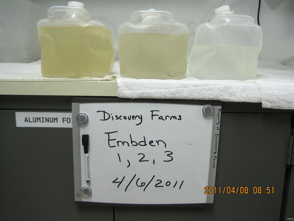
Embden Samples
Grab samples from Embden waterway sites 1, 2, and 3 on April 6, 2011. Grab samples are often collected as a quality assurance.
Grab samples from Embden waterway sites 1, 2, and 3 on April 6, 2011. Grab samples are often collected as a quality assurance.

Des Lacs River near Foxholm North Dakota
April 7, 2011, Ice break up in the Des Lacs River near Foxholm, ND.
April 7, 2011, Ice break up in the Des Lacs River near Foxholm, ND.

Des Lacs River near Foxholm North Dakota
April 7, 2011, ice break up in the Des Lacs River near Foxholm, ND.
April 7, 2011, ice break up in the Des Lacs River near Foxholm, ND.
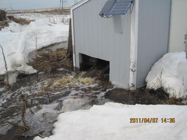
Discovery Farms Underwood Waterway
North Dakota Discovery Farms Underwood waterway site 3 at Underwood, ND.
North Dakota Discovery Farms Underwood waterway site 3 at Underwood, ND.

Flood of April 25, 2011, Town Branch trib., Hwy 16
Flood of April 25, 2011, Town Branch trib., Hwy 16Flood of April 25, 2011, at U.S. Geological Survey (USGS) streamflow-gaging station 07048490, Town Branch tributary at Highway 16 at Fayetteville, Arkansas. Photograph by D.M. Wagner, Lower Mississippi-Gulf Water Science Center.
SIR 2016–5081

Flood of April 25, 2011, White River, Ark.
Flood of April 25, 2011, at USGS streamflow-gaging station 07048600, White River near Fayetteville, Arkansas. Photograph by K.M. Hubbs, Lower Mississippi-Gulf Water Science Center.
SIR 2016–5081
Flood of April 25, 2011, at USGS streamflow-gaging station 07048600, White River near Fayetteville, Arkansas. Photograph by K.M. Hubbs, Lower Mississippi-Gulf Water Science Center.
SIR 2016–5081

Dust Storm near Winslow, Arizona, in April 2011
Dust carried by the wind has far-reaching effects, including the loss of nutrients and water-holding capacity from landscapes, and the speeding up of the melting of snow, which affects the timing and magnitude of runoff into streams and rivers.
Dust carried by the wind has far-reaching effects, including the loss of nutrients and water-holding capacity from landscapes, and the speeding up of the melting of snow, which affects the timing and magnitude of runoff into streams and rivers.

Northern Pike
An Alaska Fish and Game technician poses with an invasive northern pike (Esox lucius) taken from Alexander Creek in the Susitna Basin of south-central Alaska.
An Alaska Fish and Game technician poses with an invasive northern pike (Esox lucius) taken from Alexander Creek in the Susitna Basin of south-central Alaska.

Ice Breakup
Ice breaking up on the Red River of the North at Grand Forks, North Dakota, East Grand Forks, Minnestoa.
Ice breaking up on the Red River of the North at Grand Forks, North Dakota, East Grand Forks, Minnestoa.

Ice Breakup
Ice breaking up on the Red Lake River, Fisher, Minnesota, April 1, 2011.
Ice breaking up on the Red Lake River, Fisher, Minnesota, April 1, 2011.

Radar Gage Knocked Over
The radar gage at James River above Arrowwood Lake near Kensal, North Dakota was knocked over by ice.
The radar gage at James River above Arrowwood Lake near Kensal, North Dakota was knocked over by ice.

Caught Pallid Sturgeon
U.S. Fish & Wildlife Service employee holds a pallid sturgeon caught on a trotline at Lock and Dam 1 on the Osage River. The concrete pillars and walls in the background of the photo are what remains of the Lock and Dam 1 structure.
U.S. Fish & Wildlife Service employee holds a pallid sturgeon caught on a trotline at Lock and Dam 1 on the Osage River. The concrete pillars and walls in the background of the photo are what remains of the Lock and Dam 1 structure.

Alexander Creek in the Susitna Basin
Researchers with the Alaska Fish and Game travel along Alexander Creek in the Susitna Basin of south-central Alaska. The team is on their way to a back country base-camp for a study examining the preferred diet of invasive northern pike (Esox lucius).
Researchers with the Alaska Fish and Game travel along Alexander Creek in the Susitna Basin of south-central Alaska. The team is on their way to a back country base-camp for a study examining the preferred diet of invasive northern pike (Esox lucius).

Dust Storm Near Winslow, Arizona, in April 2011
Dust carried by the wind has far-reaching effects, including the loss of nutrients and water-holding capacity from landscapes, and the speeding up of the melting of snow, which affects the timing and magnitude of runoff into streams and rivers.
Dust carried by the wind has far-reaching effects, including the loss of nutrients and water-holding capacity from landscapes, and the speeding up of the melting of snow, which affects the timing and magnitude of runoff into streams and rivers.

Red River
Looking upstream on the Red River of the North at Grand Forks, North Dakota, East Grand Forks, Minnestoa.
Looking upstream on the Red River of the North at Grand Forks, North Dakota, East Grand Forks, Minnestoa.

Beaver Creek near Montpelier, North Dakota
Ice in Beaver Creek near Montpelier, North Dakota.
Ice in Beaver Creek near Montpelier, North Dakota.