
Ice formations forming at Apple Creek.
Images
Images
Filter Total Items: 9448

Ice Formations Forming
Ice formations forming at Apple Creek.
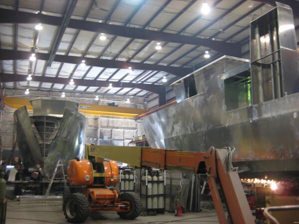
Great Lakes Research Vessel Construction
Two new additions to the U.S. Geological Survey Great Lakes Science Center's fleet of large research vessels are currently being constructed. The two new USGS research vessels will replace the aging vessels on lakes Erie and Ontario.
Two new additions to the U.S. Geological Survey Great Lakes Science Center's fleet of large research vessels are currently being constructed. The two new USGS research vessels will replace the aging vessels on lakes Erie and Ontario.
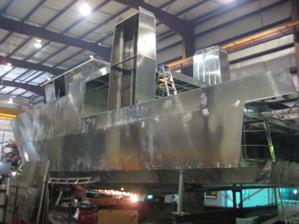

Boulder Geomagnetic Observatory
Azimuth mark, Absolutes building and Coil building at Boulder magnetic observatory.
Azimuth mark, Absolutes building and Coil building at Boulder magnetic observatory.

Lava Erupts Above the Surrounding Forest
Lava, erupting from the southwestern vent of the Kamoamoa eruption, fountains above the surrounding forest.
Lava, erupting from the southwestern vent of the Kamoamoa eruption, fountains above the surrounding forest.

Overview of the Kamoamoa Eruption
Overview of the Kamoamoa eruption looking northeast toward Pu'u 'O 'o, in the background. The southwestern vent is in the foreground, while the northeastern vent is the distant fume at the base of Pu'u 'O 'o.
Overview of the Kamoamoa eruption looking northeast toward Pu'u 'O 'o, in the background. The southwestern vent is in the foreground, while the northeastern vent is the distant fume at the base of Pu'u 'O 'o.

Northeastern Vent of the Kamoamoa Eruption
View looking down onto the northeastern vent.

Lava Fountains from the Northeastern Vent of the Kamoamoa Eruption
Lava Fountains from the Northeastern Vent of the Kamoamoa EruptionLava fountains from the northeastern vent of the Kamoamoa eruption. Though it is an impressive sight, the Pu'u 'O 'o cone in the background, and several hundred meters higher, puts the current activity into perspective.

Overview of the Kamoamoa Eruption
Overview of the Kamoamoa eruption looking south. The northeastern vent is to the left, and the southwestern vent is to the upper right. A river of lava, erupting from the southwestern vent, can be seen advancing toward the southeast through forest within Hawai'i Volcanoes National Park.
Overview of the Kamoamoa eruption looking south. The northeastern vent is to the left, and the southwestern vent is to the upper right. A river of lava, erupting from the southwestern vent, can be seen advancing toward the southeast through forest within Hawai'i Volcanoes National Park.

Thermal View Into the Halema'uma'u Vent
Views into the Halema'uma'u vent have been largely obscured by fume over the past several days, and the only consistent views have been with a thermal camera, which can "see" through the fume. This thermal image was taken at a nearly vertical angle from a helicopter, in order to see the bottom of the extremely deep and narrow vent cavity.
Views into the Halema'uma'u vent have been largely obscured by fume over the past several days, and the only consistent views have been with a thermal camera, which can "see" through the fume. This thermal image was taken at a nearly vertical angle from a helicopter, in order to see the bottom of the extremely deep and narrow vent cavity.

Lava Ejecting Above Tree Line
Lava was reaching heights above the tree line.
Lava was reaching heights above the tree line.

Lava Flow from Eruption Fissure
Lava from the erupting fissure produced a large flow that is moving southeast through the adjacent forest.
Lava from the erupting fissure produced a large flow that is moving southeast through the adjacent forest.

Plume Created From a Collapse of the Upper Portion of the Halema'uma'u Vent Cavity
Plume Created From a Collapse of the Upper Portion of the Halema'uma'u Vent CavityWith lava retreating deeper into the Halema'uma'u vent cavity over the past two days, the cavity walls have experienced more frequent collapses. At 2:23pm today (March 7), a collapse from the upper portion of the vent cavity produced a robust brown plume, but did not eject any large particles.

Radiograph of Three Belding's Ground Squirrels
Radiograph of 3 Belding's Ground Squirrels showing the presence of lead pieces (white flecks in the bodies).
Radiograph of 3 Belding's Ground Squirrels showing the presence of lead pieces (white flecks in the bodies).

West End of the Fissure System
On the west end of the fissure system, spatter ramparts are forming as the lava fallout solidifies in a mound upwind from the source.
On the west end of the fissure system, spatter ramparts are forming as the lava fallout solidifies in a mound upwind from the source.

Kamoamoa Fissures Between Napau Crater and Pu'u 'O 'o
Kamoamoa Fissures Between Napau Crater and Pu'u 'O 'oA view of the spattering source from the ground.
Kamoamoa Fissures Between Napau Crater and Pu'u 'O 'o
Kamoamoa Fissures Between Napau Crater and Pu'u 'O 'oA view of the spattering source from the ground.

A Piece of Spatter Ejected
A piece of spatter ejected on March 7, 2011. Handheld GPS for scale.
A piece of spatter ejected on March 7, 2011. Handheld GPS for scale.

Kamoamoa Fissures Between Napau Crater and Pu'u 'O 'o
Kamoamoa Fissures Between Napau Crater and Pu'u 'O 'oA close-up of the flow front in the forest.
Kamoamoa Fissures Between Napau Crater and Pu'u 'O 'o
Kamoamoa Fissures Between Napau Crater and Pu'u 'O 'oA close-up of the flow front in the forest.

Des Lacs River Second Ice Formation
New ice formations observed forming below weir at Des Lacs River near Foxholm, North Dakota.
New ice formations observed forming below weir at Des Lacs River near Foxholm, North Dakota.

A Broad View of the Kamoamoa Fissures
A broad view of the Kamoamoa fissures. The fissures extend 2.3 km (1.4 mi) between Napau Crater and Pu'u 'O 'o. The western most fissure is just out of view in this photo.
A broad view of the Kamoamoa fissures. The fissures extend 2.3 km (1.4 mi) between Napau Crater and Pu'u 'O 'o. The western most fissure is just out of view in this photo.