
View toward the SW of fissure eruption. Fissure segment in forest has shut down. Compare to earlier photos before fissure opened up in tephra.
Images
Images
Filter Total Items: 9448

Fissure Eruption
View toward the SW of fissure eruption. Fissure segment in forest has shut down. Compare to earlier photos before fissure opened up in tephra.

Fissure Eruption South West of Pu'u 'O 'o
Close-up of recently opened fissure segment. Spatter reaching about 5m into the air.
Close-up of recently opened fissure segment. Spatter reaching about 5m into the air.

Ash Cloud Rising From Pu'u 'O 'o as Crater Floor Collapses
Ash Cloud Rising From Pu'u 'O 'o as Crater Floor CollapsesIncandescent rubble rolling and sliding down the scarp on the edge of the collapsing crater in Pu'u 'O 'o. A remnant of the pre-collapse crater floor can be seen in the background below the crater's south wall. The east rim of Pu'u 'O 'o is in the foreground.

Fissure Eruption
Close-up of spattering fissure. Lava reaching 10m into the air.
Close-up of spattering fissure. Lava reaching 10m into the air.

Large Ice Formation
USGS personnel (5'8") stands next to ice formation at Big Muddy Creek. Flow is 6.45 cubic feet per second.
USGS personnel (5'8") stands next to ice formation at Big Muddy Creek. Flow is 6.45 cubic feet per second.

James River at Huron, SD Streamgage
USGS hydrologic technicians Tyler Meyer and Jesse Rigge document the river stage and ensure that the streamgage on the James River at Huron, SD is working properly. A streamflow measurement of 17,500 cubic feet per second was made during the site visit.
USGS hydrologic technicians Tyler Meyer and Jesse Rigge document the river stage and ensure that the streamgage on the James River at Huron, SD is working properly. A streamflow measurement of 17,500 cubic feet per second was made during the site visit.

Northern Pike
Example of a fish species positively impacted by the hydrologic reconnection of a diked wetland to Lake Erie. Northern Pike depend on productive wetland habitats to spawn.
Example of a fish species positively impacted by the hydrologic reconnection of a diked wetland to Lake Erie. Northern Pike depend on productive wetland habitats to spawn.
Emben Waterway Sites
North Dakota Discovery Farms Embden waterway sites 1 and 2 located southeast Cass County about 8 miles south of Embden, North Dakota.
North Dakota Discovery Farms Embden waterway sites 1 and 2 located southeast Cass County about 8 miles south of Embden, North Dakota.
Embden Waterway Sites
North Dakota Discovery Farms waterway sites 1 & 2 located in southeast Cass County about 8 miles south of Embden, North Dakota. In 2009, Embden became the third farm in the North Dakota Discovery Farms project. Farm is located about 1/2 mile south of data shelters. Embden 1 is a surace-water site.
North Dakota Discovery Farms waterway sites 1 & 2 located in southeast Cass County about 8 miles south of Embden, North Dakota. In 2009, Embden became the third farm in the North Dakota Discovery Farms project. Farm is located about 1/2 mile south of data shelters. Embden 1 is a surace-water site.

Ice breakup on the Skunk River
This image and associated video captures the breakup of ice cover on the Skunk River at Augusta, Iowa, on February 17, 2011, at approximately 3:00 p.m. local time. The river stage at the time was 14.50 feet (elevation 1,179.41 feet NGVD29).
This image and associated video captures the breakup of ice cover on the Skunk River at Augusta, Iowa, on February 17, 2011, at approximately 3:00 p.m. local time. The river stage at the time was 14.50 feet (elevation 1,179.41 feet NGVD29).

Des Lacs River First Ice Spikes Disappeared
Increase flow in the Des Lacs River and warmer temperatures probably caused instability in the area of the ice spikes causing them to disappear.
Increase flow in the Des Lacs River and warmer temperatures probably caused instability in the area of the ice spikes causing them to disappear.

Whooping Crane Chick
This adolescent chick, hatched and raised at the USGS Patuxent Wildlife Research Center, is one of ten whooping cranes being released in Louisiana in February 2011. It is a milestone for the state and for the birds, which have not lived in the state since the 1950s.
This adolescent chick, hatched and raised at the USGS Patuxent Wildlife Research Center, is one of ten whooping cranes being released in Louisiana in February 2011. It is a milestone for the state and for the birds, which have not lived in the state since the 1950s.

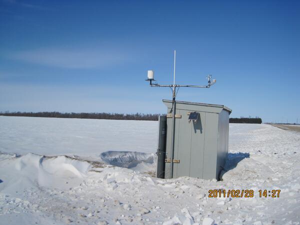
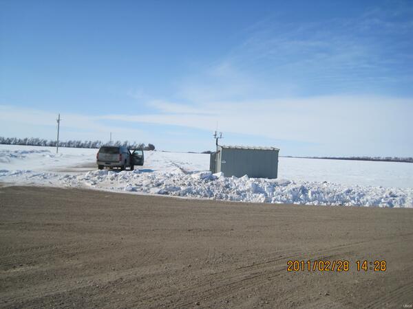
Swift River Station
This photo shows USGS gaging station 01055000 on the Swift River near Roxbury, Maine.
This photo shows USGS gaging station 01055000 on the Swift River near Roxbury, Maine.

Boa Constrictor
Boa constrictor "in situ" on a tree buttress right after some rain in Puerto Rico.
Boa constrictor "in situ" on a tree buttress right after some rain in Puerto Rico.

Removing Gage 05056255
On February 4, 2011 gage 05056255, Alice-Irvine Channel near Churchs Ferry, ND was removed due to rising water of the Devils Lake Basin. Lake elevation was 51.85 feet on the day of removal. USGS emplyees Chase(left) and Art(right).
On February 4, 2011 gage 05056255, Alice-Irvine Channel near Churchs Ferry, ND was removed due to rising water of the Devils Lake Basin. Lake elevation was 51.85 feet on the day of removal. USGS emplyees Chase(left) and Art(right).