
Performing color separation scribing of the culture separate of a USGS topographic map using a swivel graver.
Images
Images
Filter Total Items: 9452

USGS Cartographer at Work
Performing color separation scribing of the culture separate of a USGS topographic map using a swivel graver.

USGS Cartographer at Work
Color separation scribing of the intermediate contours for a USGS topographic map using a freehand scriber.
Color separation scribing of the intermediate contours for a USGS topographic map using a freehand scriber.

USGS Cartographer at Work
Color separation scribing of the contour plate for a USGS topographic map using a freehand scriber. This handheld stylist was designed to hold a phonograph needle that was sharpened to engrave a .003" scribed line.
Color separation scribing of the contour plate for a USGS topographic map using a freehand scriber. This handheld stylist was designed to hold a phonograph needle that was sharpened to engrave a .003" scribed line.

USGS Cartographer at Work
The application of transparent adhesive-backed type to the culture lettering separate of the Miller Peak, AZ 7.5-minute topographic map.
The application of transparent adhesive-backed type to the culture lettering separate of the Miller Peak, AZ 7.5-minute topographic map.

USGS Cartographer at Work
Using a swivel graver with a steel straight edge to scribe a road onto the culture plate of a topographic map.
Using a swivel graver with a steel straight edge to scribe a road onto the culture plate of a topographic map.

Panoramic of Glaciers in the Caucasus Moutains
Panoramic photographic mosaic of several glaciers on the northern slope of Gora Elbrus, a volcanic massif in the Central Caucasus Mountains. The photographic survey was done by N. Nikulin in 1957 during the International Geophysical Year. Photograph courtesy of V.M. Kotlyakov, Russian Academy of Sciences, Moscow.
Panoramic photographic mosaic of several glaciers on the northern slope of Gora Elbrus, a volcanic massif in the Central Caucasus Mountains. The photographic survey was done by N. Nikulin in 1957 during the International Geophysical Year. Photograph courtesy of V.M. Kotlyakov, Russian Academy of Sciences, Moscow.

Old Stone Field Marker
This is a stone field marker that marked boundaries for land ownership. In the early days of Land Office Recordings, this is one type of monument used. Trees, Posts, Iron Pipes and as shown stones were used to mark off land during the Land Rush days.
This is a stone field marker that marked boundaries for land ownership. In the early days of Land Office Recordings, this is one type of monument used. Trees, Posts, Iron Pipes and as shown stones were used to mark off land during the Land Rush days.

Artesian Well Investigations
Artesian well investigations in South Dakota (circa 1956-62).
Artesian well investigations in South Dakota (circa 1956-62).

USGS station 081090 Brazos River near Bryan, Texas
USGS station 081090 Brazos River near Bryan, TexasU.S. Geological Survey streamflow-gaging station 08109000 Brazos River near Bryan, Texas, looking upstream from left bank, February 5, 1954.
SIR 2009–5174
USGS station 081090 Brazos River near Bryan, Texas
USGS station 081090 Brazos River near Bryan, TexasU.S. Geological Survey streamflow-gaging station 08109000 Brazos River near Bryan, Texas, looking upstream from left bank, February 5, 1954.
SIR 2009–5174

Muir and Riggs Glaciers, Muir Inlet, Alaska - 1950
Muir and Riggs Glaciers, Muir Inlet, Alaska - 1950This, the first of two repeat photographs, documents significant changes that have occurred during the nine years between photographs A and B. Although Muir Glacier has retreated more than 3 kilometers and thinned more than 100 meters, exposing Muir Inlet, it remains connected with tributary Riggs Glacier. White Thunder Ridge remains devoid of vegetation.
Muir Glacier in Glacier Bay National Monument 1950
Muir Glacier in Glacier Bay National Monument 1950This August 1950 photo documents the significant changes that occurred during the 9 years between photographs A and B. Muir Glacier has retreated more than 2 miles, exposing Muir Inlet, and thinned 340 feet or more. However, it still is connected with tributary Riggs Glacier.

USGS station 08110500 Navasota Riv. near Easterly, Tex.
USGS station 08110500 Navasota Riv. near Easterly, Tex.U.S. Geological Survey streamflow-gaging station 08110500 Navasota River near Easterly, Texas, looking downstream from left bank, December 5, 1941.
SIR 2009–5174
USGS station 08110500 Navasota Riv. near Easterly, Tex.
USGS station 08110500 Navasota Riv. near Easterly, Tex.U.S. Geological Survey streamflow-gaging station 08110500 Navasota River near Easterly, Texas, looking downstream from left bank, December 5, 1941.
SIR 2009–5174
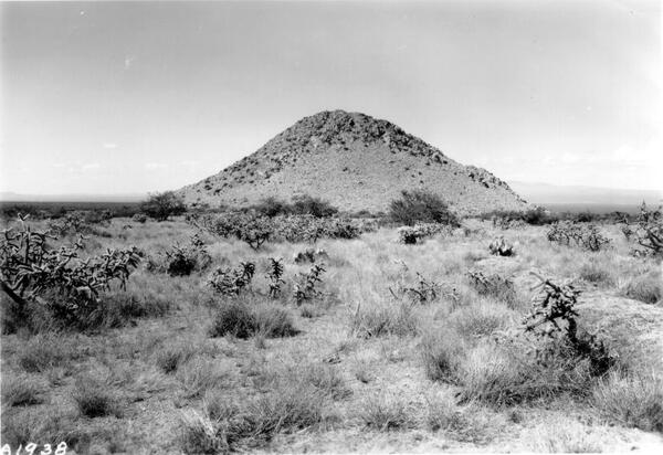
Huérfano Butte, Santa Rita Experimental Range, Southern Arizona - 1941
Huérfano Butte, Santa Rita Experimental Range, Southern Arizona - 1941Members of the 1930s burrowed and cholla eruptions were visible in 1941 as well as new mesquite plants that were already quite large. (Photographer unknown).
Huérfano Butte, Santa Rita Experimental Range, Southern Arizona - 1941
Huérfano Butte, Santa Rita Experimental Range, Southern Arizona - 1941Members of the 1930s burrowed and cholla eruptions were visible in 1941 as well as new mesquite plants that were already quite large. (Photographer unknown).

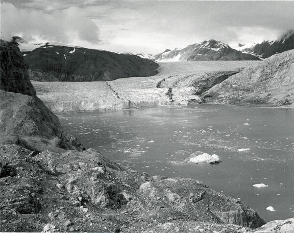
Muir and Riggs Glaciers, Muir Inlet, Alaska - 1941
Muir and Riggs Glaciers, Muir Inlet, Alaska - 1941This northeast-looking photograph, on the southeastern side of White Thunder Ridge ,shows the lower reaches of Muir Glacier, then a large tidewater calving valley glacier, and its tributary Riggs Glacier. The séracs in the lower right-hand corner of the photograph mark Muir Glacier’s terminus. The ice thickness is more than 700 meters.
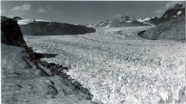
Muir Glacier in Glacier Bay National Monument 1941
Muir Glacier in Glacier Bay National Monument 1941This August 1941 photograph is of Muir Glacier in Glacier Bay National Monument, Alaska. It shows the lower reaches of Muir Glacier, then a large, tidewater calving valley glacier and its tributary, Riggs Glacier. For nearly two centuries before 1941, Muir Glacier had been retreating. In places, a thickness of more than two-thirds of a mile of ice had been lost.

USGS Topographic Field Party
A mounted topographic field party poses while working on the Dos Cabezas quadrangle in Arizona. 1940-1941. The quadrangle was surveyed by D.H. Rutledge, W.E. Burton, and G.K. Jensen, so it is likely that most or all of them are in this photo.
A mounted topographic field party poses while working on the Dos Cabezas quadrangle in Arizona. 1940-1941. The quadrangle was surveyed by D.H. Rutledge, W.E. Burton, and G.K. Jensen, so it is likely that most or all of them are in this photo.
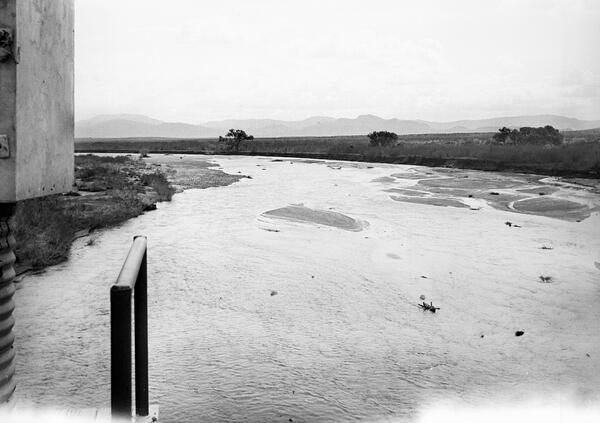
San Carlos River near Peridot, Southern Arizona - 1940
San Carlos River near Peridot, Southern Arizona - 1940In 1940, the gaging station for the San Carlos River was on a railroad bridge south of the little town of Peridot. This downstream view from that bridge shows the gage house on the extreme left and a safety railing next to it. The channel is wide following a flood, and scattered Frémont cottonwood trees are along channel right.

Bird Migration Card - 1937
Image scan of a historical bird migration card.
Image scan of a historical bird migration card.
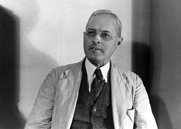
George Rogers Mansfield. Washington, D.C. 1934.
A Portrait of George Rogers Mansfield. Washington, D.C. 1934. Mansfield was a geologist.
A Portrait of George Rogers Mansfield. Washington, D.C. 1934. Mansfield was a geologist.

USGS station 08110500 Navasota Riv. near Easterly, Tex.
USGS station 08110500 Navasota Riv. near Easterly, Tex.U.S. Geological Survey streamflow-gaging station 08110500 Navasota River near Easterly, Texas, looking upstream, June 7, 1934.
SIR 2009–5174
USGS station 08110500 Navasota Riv. near Easterly, Tex.
USGS station 08110500 Navasota Riv. near Easterly, Tex.U.S. Geological Survey streamflow-gaging station 08110500 Navasota River near Easterly, Texas, looking upstream, June 7, 1934.
SIR 2009–5174