
USGS scientists were deployed to assess land deformation and movement after a large M6.4 earthquake struck Puerto Rico on January 7, 2020. This landslide was discovered along a neighborhood road near Ponce, Puerto Rico.
Images
Images
Filter Total Items: 9454

Landslide along road near Ponce, Puerto Rico
USGS scientists were deployed to assess land deformation and movement after a large M6.4 earthquake struck Puerto Rico on January 7, 2020. This landslide was discovered along a neighborhood road near Ponce, Puerto Rico.

USGS Earthquake Response team with governor of Puerto Rico
USGS Earthquake Response team with governor of Puerto RicoUSGS team with Wanda Vazquez-Garced, governor of Puerto Rico. From left to right: Lindsay Davis, Wanda Vazquez, Dianne Lopez-Trujillo, Jonathan Godt, Donyelle Davis, Alex Grant
USGS Earthquake Response team with governor of Puerto Rico
USGS Earthquake Response team with governor of Puerto RicoUSGS team with Wanda Vazquez-Garced, governor of Puerto Rico. From left to right: Lindsay Davis, Wanda Vazquez, Dianne Lopez-Trujillo, Jonathan Godt, Donyelle Davis, Alex Grant

Analyzing Earthquake Data in Puerto Rico
USGS scientists Thomas L. Pratt and Alena L. Leads, along with Dr. Elizabeth Vanacore, associate research professor at University of Puerto Rico, analyze data in earthquake monitoring and recording equipment amid aftershocks across the island's southern coast.
USGS scientists Thomas L. Pratt and Alena L. Leads, along with Dr. Elizabeth Vanacore, associate research professor at University of Puerto Rico, analyze data in earthquake monitoring and recording equipment amid aftershocks across the island's southern coast.

Installing a temporary seismometer
Photo (L-R) Jose Cancel of Puerto Rico Seismic Network (PRSN), Alena Leeds of USGS and Javier Santiago of PRSN install a temporary seismometer at Sabana Yeguas in southwestern Puerto Rico on Jan. 10, 2020.
Photo (L-R) Jose Cancel of Puerto Rico Seismic Network (PRSN), Alena Leeds of USGS and Javier Santiago of PRSN install a temporary seismometer at Sabana Yeguas in southwestern Puerto Rico on Jan. 10, 2020.

Seismometer installation in Ridgecrest, California
Seismometer installation in Ridgecrest, CaliforniaUSGS scientists Nicholas van der Elst and Alan Yong installing a seismometer near the 2019 Ridgecrest earthquakes in southern California in order to record its aftershocks.
Seismometer installation in Ridgecrest, California
Seismometer installation in Ridgecrest, CaliforniaUSGS scientists Nicholas van der Elst and Alan Yong installing a seismometer near the 2019 Ridgecrest earthquakes in southern California in order to record its aftershocks.
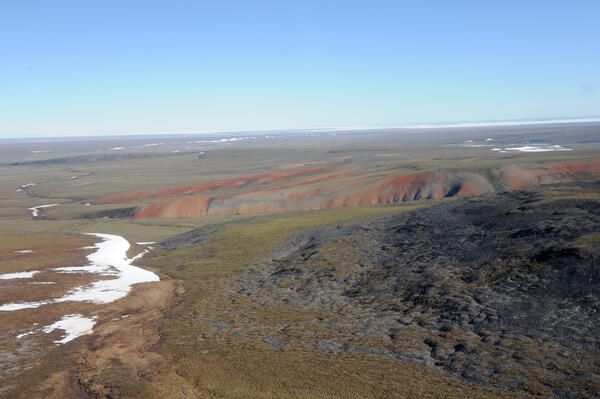
View to northeast from southwestern ANWR-1002 Area; ice in Camden Bay
View to northeast from southwestern ANWR-1002 Area; ice in Camden BayView to northeast from southwestern Arctic National Wildlife Refuge-1002 Area with ice in Camden Bay in distance. In foreground, red-weathering rocks are Hue Shale (oil-prone source rock with is present throughout 1002 Area) and dark gray rocks are Kemik Sandstone (lateral equivalent to Thomson sandstone, main reservoir in Pt. Thomson field).

tundra surface and lakes on Canning River Delta
Southward view of tundra surface and lakes on Canning River Delta near northwestern corner of Arctic National Wildlife Refuge-1002 Area.
Southward view of tundra surface and lakes on Canning River Delta near northwestern corner of Arctic National Wildlife Refuge-1002 Area.

Oil-saturated Miocene or younger sandstone in the Sagavanirktok Fm.
Oil-saturated Miocene or younger sandstone in the Sagavanirktok Fm.Oil-saturated Miocene or younger sandstone in the Sagavanirktok Formation exposed at Angun Point on the coast of the Arctic Ocean, northeastern Arctic National Wildlife Refuge-1002 Area.

Yosemite toad caught on camera crossing beneath "toad road" structure
Yosemite toad caught on camera crossing beneath "toad road" structureThis is remote capture image of a Yosemite toad seen crossing beneath "toad road" structure built atop a forest road in the Sierra National Forest. Reseachers are exploring tools, such as this elevated road structure, or "toad road," to reduce vehicle strikes to this threatened species.

Well on Restored Prairie
A well at a restored prairie on Lake Agassiz beach ridge, Glacial Ridge National Wildlife Refuge
A well at a restored prairie on Lake Agassiz beach ridge, Glacial Ridge National Wildlife Refuge

Fog Over Glacial Ridge National Wildlife Refuge
Morning fog over beach ridges at Glacial Ridge National Wildlife Refuge
Morning fog over beach ridges at Glacial Ridge National Wildlife Refuge

Prairie Dog, Glacial Ridge National Wildlife Refuge
Prairie Dog, Glacial Ridge National Wildlife RefugePrairie Dog, Glacial Ridge National Wildlife Refuge
Prairie Dog, Glacial Ridge National Wildlife Refuge
Prairie Dog, Glacial Ridge National Wildlife RefugePrairie Dog, Glacial Ridge National Wildlife Refuge

View to the southeast from near the Canning River Delta
View to the southeast from near the Canning River DeltaView to the southeast from near the Canning River Delta. Visible in foreground are permafrost polygons cut by caribou trails.
Arctic National Wildlife Refuge
View to the southeast from near the Canning River Delta
View to the southeast from near the Canning River DeltaView to the southeast from near the Canning River Delta. Visible in foreground are permafrost polygons cut by caribou trails.
Arctic National Wildlife Refuge

Canning River Delta with thin barrier island and ice pack
Canning River Delta with thin barrier island and ice packNorthward view to coast of Canning River Delta with thin barrier island and ice pack beyond.
Canning River Delta with thin barrier island and ice pack
Canning River Delta with thin barrier island and ice packNorthward view to coast of Canning River Delta with thin barrier island and ice pack beyond.

Camden Bay from west-central ANWR-1002 Area
Northward view towards Camden Bay from west-central Arctic National Wildlife Refuge-1002 Area near the Katakturuk River. Patterns in foreground are permafrost polygons.
Northward view towards Camden Bay from west-central Arctic National Wildlife Refuge-1002 Area near the Katakturuk River. Patterns in foreground are permafrost polygons.

ANWR-1002 Area near Okerokorik River
Northward view from southeastern corner of Arctic National Wildlife Refuge-1002 Area near Okerokorik River showing gently rolling topography typical of the southern coastal plain.
Northward view from southeastern corner of Arctic National Wildlife Refuge-1002 Area near Okerokorik River showing gently rolling topography typical of the southern coastal plain.

ANWR-1002 Area west of the Aichilik River
View to the northeast from near the eastern boundary of the Arctic National Wildlife Refuge-1002 Area west of the Aichilik River.
View to the northeast from near the eastern boundary of the Arctic National Wildlife Refuge-1002 Area west of the Aichilik River.

oil-saturated sand, sandstone, and concretions along the Jago River
oil-saturated sand, sandstone, and concretions along the Jago RiverGeologists examine oil-saturated sand (unconsolidated), sandstone (dark orange-brown rocks), and concretions (light orange rocks) along the Jago River in the Arctic National Wildlife Refuge-1002 Area, about 18 miles southeast of Kaktovik.
Fog Over Glacial Ridge Refuge
Fog Over Glacial Ridge National Wildlife Refuge
Fog Over Glacial Ridge National Wildlife Refuge

Arctic National Wildlife Refuge-1002 Area near the Sadlerochit River
Arctic National Wildlife Refuge-1002 Area near the Sadlerochit RiverNorthward view in central Arctic National Wildlife Refuge-1002 Area near the Sadlerochit River showing gently rolling topography typical of the southern coastal plain and meandering creek.

along Sabbath Creek, a tributary of the Jago River
along Sabbath Creek, a tributary of the Jago RiverNorthward view towards Kaktovik from southeastern Arctic National Wildlife Refuge-1002 Area. Location is along Sabbath Creek, a tributary of the Jago River.
along Sabbath Creek, a tributary of the Jago River
along Sabbath Creek, a tributary of the Jago RiverNorthward view towards Kaktovik from southeastern Arctic National Wildlife Refuge-1002 Area. Location is along Sabbath Creek, a tributary of the Jago River.