Earth MRI Funds Critical Minerals Projects in Texas
Earth MRI Funds Critical Minerals Projects in TexasUSGS map of Earth MRI projects in Texas' Trans-Pecos region announced in September 2020.

Official websites use .gov
A .gov website belongs to an official government organization in the United States.
Secure .gov websites use HTTPS
A lock () or https:// means you’ve safely connected to the .gov website. Share sensitive information only on official, secure websites.
Images

USGS map of Earth MRI projects in Texas' Trans-Pecos region announced in September 2020.
USGS map of Earth MRI projects in Texas' Trans-Pecos region announced in September 2020.

A black carp collected by USGS scientists from the Mississippi River. Credit: USGS.
A black carp collected by USGS scientists from the Mississippi River. Credit: USGS.

Landsat 8 image on the Utah-Arizona Border on the Navajo Nation acquired on September 18, 2020.
For more information about Landsat, please visit www.usgs.gov/Landsat
To download the data, visit earthexplorer.usgs.gov
Landsat 8 image on the Utah-Arizona Border on the Navajo Nation acquired on September 18, 2020.
For more information about Landsat, please visit www.usgs.gov/Landsat
To download the data, visit earthexplorer.usgs.gov

Throughout the historically active 2020 Atlantic Hurricane Season,USGS hydrologists have been working quickly to collect vital flood and streamflow information in impacted areas.
Throughout the historically active 2020 Atlantic Hurricane Season,USGS hydrologists have been working quickly to collect vital flood and streamflow information in impacted areas.

In this NOAA satellite image from Sept. 15, 2020, Hurricane Sally approaches the U.S. Gulf Coast, Hurricane Paulettte creates storm waves far out in the Atlantic, and Tropical Storms Teddy and Vicky lie near the coast of Africa. Two tropical depressions are also developing; one of them is not visible in this image.
In this NOAA satellite image from Sept. 15, 2020, Hurricane Sally approaches the U.S. Gulf Coast, Hurricane Paulettte creates storm waves far out in the Atlantic, and Tropical Storms Teddy and Vicky lie near the coast of Africa. Two tropical depressions are also developing; one of them is not visible in this image.

USGS scientist John Fulton measures streamflow on Middle Fork Ranch Creek, Colorado using instream, conventional methods. USGS radar equipment is also shown recording non-contact river discharge.
USGS scientist John Fulton measures streamflow on Middle Fork Ranch Creek, Colorado using instream, conventional methods. USGS radar equipment is also shown recording non-contact river discharge.

A firefighter wearing safety gear and holding a drip torch walks away from a line of burning vegetation.
A firefighter wearing safety gear and holding a drip torch walks away from a line of burning vegetation.

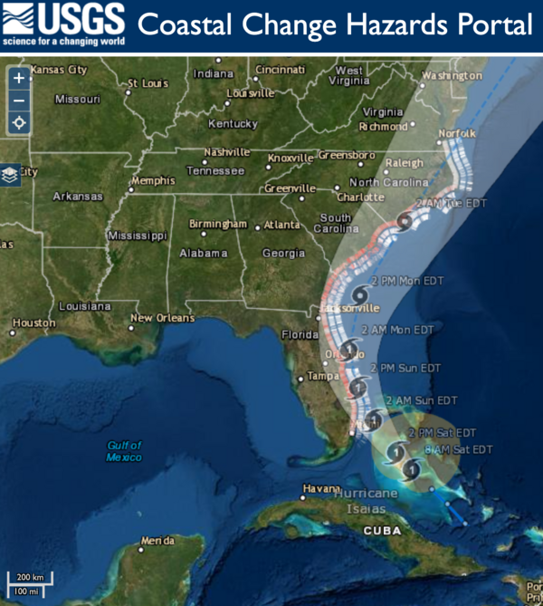
This Coastal Change Storm Hazard Team forecast was made at 4 AM CDT August 26, 2020 and shows forecast beach erosion at the base of the dunes (the strip of colored bars closest to the coast), overwash (middle strip) and inundation (outer strip) from Hurricane Laura. The model accounts for sandy beaches and barrier islands and does not include marshes,
This Coastal Change Storm Hazard Team forecast was made at 4 AM CDT August 26, 2020 and shows forecast beach erosion at the base of the dunes (the strip of colored bars closest to the coast), overwash (middle strip) and inundation (outer strip) from Hurricane Laura. The model accounts for sandy beaches and barrier islands and does not include marshes,

This USGS streamgage on Schantz Spring near Wescosville, Pennsylvania was partially submerged after floodwaters from Tropical Storm Isaias quickly rose and flooded the area.
This USGS streamgage on Schantz Spring near Wescosville, Pennsylvania was partially submerged after floodwaters from Tropical Storm Isaias quickly rose and flooded the area.

Fisseha Mengistu, USGS hydrologic technician, uses a device that lowers a water sampler into the creek below to collect samples used for water quality testing. Experts will be able to use this data to track how Tropical Storm Isaias impacted water quality in the area. This work was done on Rock Creek in Washington, D.C.
Fisseha Mengistu, USGS hydrologic technician, uses a device that lowers a water sampler into the creek below to collect samples used for water quality testing. Experts will be able to use this data to track how Tropical Storm Isaias impacted water quality in the area. This work was done on Rock Creek in Washington, D.C.

This USGS storm tide sensor was installed August 1 in North Myrtle Beach, South Carolina to measure the coastal impacts of Hurricane Isaias. Photo by Joshua Lee, USGS.
This USGS storm tide sensor was installed August 1 in North Myrtle Beach, South Carolina to measure the coastal impacts of Hurricane Isaias. Photo by Joshua Lee, USGS.
USGS coastal change experts predict that storm waves kicked up by the Category 1 hurricane are likely to cause some erosion at the base of the dunes along about 11 percent of coastal beaches between Florida and Virginia.
USGS coastal change experts predict that storm waves kicked up by the Category 1 hurricane are likely to cause some erosion at the base of the dunes along about 11 percent of coastal beaches between Florida and Virginia.

This rapid deployment gauge was installed August 1 in Swansboro, North Carolina on the White Oak River to monitor water levels in order track potential flooding caused by Tropical Storm Isaias. Photo by Bryce McClenney, USGS.
This rapid deployment gauge was installed August 1 in Swansboro, North Carolina on the White Oak River to monitor water levels in order track potential flooding caused by Tropical Storm Isaias. Photo by Bryce McClenney, USGS.

This oblique view looking toward the northwest shows the location where a river valley cuts through the rim of Jezero crater and ends in a fan-shaped delta deposit. The Perseverance Mars rover will land near this delta to search for evidence of past life and collect samples that could be returned to Earth by a later mission.
This oblique view looking toward the northwest shows the location where a river valley cuts through the rim of Jezero crater and ends in a fan-shaped delta deposit. The Perseverance Mars rover will land near this delta to search for evidence of past life and collect samples that could be returned to Earth by a later mission.

Description: This is a high-resolution oblique view of the southern edge of the delta deposit in Jezero crater, the landing site for the Perseverance Mars rover. In the foreground, a butte of delta material stands above the crater floor.
Description: This is a high-resolution oblique view of the southern edge of the delta deposit in Jezero crater, the landing site for the Perseverance Mars rover. In the foreground, a butte of delta material stands above the crater floor.

Description: This is a high-resolution oblique view of the northeastern edge of the delta deposit in Jezero crater, the landing site for the Perseverance Mars rover. In the foreground, buttes of delta material stand above the crater floor. On the left and in the middle of this image, the layered rocks of the delta deposit are visible.
Description: This is a high-resolution oblique view of the northeastern edge of the delta deposit in Jezero crater, the landing site for the Perseverance Mars rover. In the foreground, buttes of delta material stand above the crater floor. On the left and in the middle of this image, the layered rocks of the delta deposit are visible.

When you’re planning to explore someplace new, it’s always a good idea to bring a map so you can avoid dangerous terrain. This is true whether you’re heading out for a hike on Earth or you’re landing a rover on Mars!
When you’re planning to explore someplace new, it’s always a good idea to bring a map so you can avoid dangerous terrain. This is true whether you’re heading out for a hike on Earth or you’re landing a rover on Mars!

Description: This oblique view looks to the west from above the Jezero crater floor, over the fan-shaped delta deposit, and into the valley that cuts through the crater rim. The Perseverance Mars rover will land near this delta to search for evidence of past life and collect samples that could be returned to Earth by a later mission.
Description: This oblique view looks to the west from above the Jezero crater floor, over the fan-shaped delta deposit, and into the valley that cuts through the crater rim. The Perseverance Mars rover will land near this delta to search for evidence of past life and collect samples that could be returned to Earth by a later mission.

Description: This oblique view looking toward the northwest shows the western rim and floor of Jezero crater, Mars. A river valley cuts through the rim and ends in a fan-shaped delta deposit. The Perseverance Mars rover will land near this delta to search for evidence of past life and collect samples that could be returned to Earth by a later mission.
Description: This oblique view looking toward the northwest shows the western rim and floor of Jezero crater, Mars. A river valley cuts through the rim and ends in a fan-shaped delta deposit. The Perseverance Mars rover will land near this delta to search for evidence of past life and collect samples that could be returned to Earth by a later mission.

Mineral elements provide the color in fireworks. Barium produces bright greens; strontium yields deep reds; copper produces blues; and sodium yields yellow. Other colors can be made by mixing elements: strontium and sodium produce brilliant orange; titanium, zirconium, and magnesium alloys make silvery white; copper and strontium make lavender.
Mineral elements provide the color in fireworks. Barium produces bright greens; strontium yields deep reds; copper produces blues; and sodium yields yellow. Other colors can be made by mixing elements: strontium and sodium produce brilliant orange; titanium, zirconium, and magnesium alloys make silvery white; copper and strontium make lavender.

USGS scientist Tabitha Graves collects western bumble bee samples in eastern Montana.
USGS scientist Tabitha Graves collects western bumble bee samples in eastern Montana.