
Northward view in western Arctic National Wildlife Refuge-1002 Area with ice in Camden Bay in distance. North sloping, tundra-covered surface is typical of coastal plain.
Images
Images
Filter Total Items: 9454

western ANWR-1002 Area with ice in Camden Bay
Northward view in western Arctic National Wildlife Refuge-1002 Area with ice in Camden Bay in distance. North sloping, tundra-covered surface is typical of coastal plain.

western Sadlerochit Mountains near the Tamayariak River
western Sadlerochit Mountains near the Tamayariak RiverView to northeast from western Sadlerochit Mountains near the Tamayariak River. This gently rolling topography is typical of the southern coastal plain.
western Sadlerochit Mountains near the Tamayariak River
western Sadlerochit Mountains near the Tamayariak RiverView to northeast from western Sadlerochit Mountains near the Tamayariak River. This gently rolling topography is typical of the southern coastal plain.

ANWR-1002 Area near the Jago River
View to the northeast from east-central Arctic National Wildlife Refuge-1002 Area near the Jago River.
View to the northeast from east-central Arctic National Wildlife Refuge-1002 Area near the Jago River.

ANWR-1002 Area near the Jago River
Eastward view from east-central Arctic National Wildlife Refuge-1002 Area near the Jago River. Northeastern Brooks Range visible in distance at right.
Eastward view from east-central Arctic National Wildlife Refuge-1002 Area near the Jago River. Northeastern Brooks Range visible in distance at right.

oil-saturated Oligocene sandstone in the Sagavanirktok Formation
oil-saturated Oligocene sandstone in the Sagavanirktok FormationGeologists examine oil-saturated Oligocene sandstone in the Sagavanirktok Formation exposed on Marsh Creek anticline near Katakturuk River in western Arctic National Wildlife Refuge-1002 Area. Weathered surfaces are light gray and freshly broken surfaces are brown.

Closeup view of oil-saturated Oligocene sandstone in the Sagavanirktok
Closeup view of oil-saturated Oligocene sandstone in the SagavanirktokCloseup view of oil-saturated Oligocene sandstone in the Sagavanirktok Formation exposed on Marsh Creek anticline near Katakturuk River in western Arctic National Wildlife Refuge-1002 Area. Weathered surface is light gray and freshly broken surface is brown.

Oil-saturated Miocene or younger sandstone in the Sagavanirktok Fm.
Oil-saturated Miocene or younger sandstone in the Sagavanirktok Fm.Oil-saturated Miocene or younger sandstone in the Sagavanirktok Formation exposed at Angun Point on the coast of the Arctic Ocean, northeastern Arctic National Wildlife Refuge-1002 Area.

Young Moose, Glacial Ridge National Wildlife Refuge
Young Moose, Glacial Ridge National Wildlife RefugeYoung moose near Benoit, Minnesota, Glacial Ridge National Wildlife Refuge
Young Moose, Glacial Ridge National Wildlife Refuge
Young Moose, Glacial Ridge National Wildlife RefugeYoung moose near Benoit, Minnesota, Glacial Ridge National Wildlife Refuge

Wetlands, Glacial Ridge National Wildlife Refuge
Ephemeral wetlands at Glacial Ridge National Wildlife Refuge
Ephemeral wetlands at Glacial Ridge National Wildlife Refuge

Arizona Landsat State Mosaic
Arizona is blessed with many natural wonders including the Grand Canyon, Lake Powell/Rainbow Bridge, Petrified Forest/Painted Desert, Monument Valley, Meteor Crater, and Superstition Mountain.
Capital Phoenix
Image Source Landsat 8
Population 7,151,502
Arizona is blessed with many natural wonders including the Grand Canyon, Lake Powell/Rainbow Bridge, Petrified Forest/Painted Desert, Monument Valley, Meteor Crater, and Superstition Mountain.
Capital Phoenix
Image Source Landsat 8
Population 7,151,502

Barred tiger salamander (paedomorph)
Barred Tiger Salamander Paedomorph, Cottonwood Lake Study Area, North Dakota. Some barred tiger salamanders never metamorphose and keep their larval features (e.g., gills, finlike tail) their whole lives as reproductively mature adults known as paedomorphs, which can grow to be 14 inches in length.
Barred Tiger Salamander Paedomorph, Cottonwood Lake Study Area, North Dakota. Some barred tiger salamanders never metamorphose and keep their larval features (e.g., gills, finlike tail) their whole lives as reproductively mature adults known as paedomorphs, which can grow to be 14 inches in length.

Hatching Baby Tortoise (GIF)
Animated GIF of a baby tortoise hatching out of its shell. Pulled from "The Heat is On: Desert Tortoises and Survival" video by Stephen M. Wessells.
Animated GIF of a baby tortoise hatching out of its shell. Pulled from "The Heat is On: Desert Tortoises and Survival" video by Stephen M. Wessells.
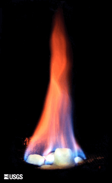
Burning Gas Hydrate
Gas hydrate is sometimes called “the ice that burns” because the warming hydrates release enough methane to sustain a flame. Credit: USGS
Gas hydrate is sometimes called “the ice that burns” because the warming hydrates release enough methane to sustain a flame. Credit: USGS

Camden Bay from west-central ANWR-1002 Area
View to the northeast towards Camden Bay from west-central Arctic National Wildlife Refuge-1002 Area. The tundra and lakes in this area displays a variety of patterns caused by permafrost.
View to the northeast towards Camden Bay from west-central Arctic National Wildlife Refuge-1002 Area. The tundra and lakes in this area displays a variety of patterns caused by permafrost.

central ANWR-1002 Area near the Sadlerochit River
Northward view in central Arctic National Wildlife Refuge-1002 Area near the Sadlerochit River showing gently rolling topography typical of the southern coastal plain.
Northward view in central Arctic National Wildlife Refuge-1002 Area near the Sadlerochit River showing gently rolling topography typical of the southern coastal plain.

Grass carp larvae
These images show grass carp larvae from the Maumee River. Characteristics of larval grass carp include overall length (left), skeletal muscle development (center) and presence of an eye spot that lacks pigmentation (right; pigment starting to develop on lower eye).
These images show grass carp larvae from the Maumee River. Characteristics of larval grass carp include overall length (left), skeletal muscle development (center) and presence of an eye spot that lacks pigmentation (right; pigment starting to develop on lower eye).

Pollinator Flight
Bumble bee landing on a cone flower provided by USGS Ecosystems Mission Area.
Bumble bee landing on a cone flower provided by USGS Ecosystems Mission Area.

USGS employees on SH 104 near the Arkansas River near Haskell, OK
USGS employees on SH 104 near the Arkansas River near Haskell, OKPhotograph showing USGS employees on State Highway 104 near the Arkansas River near Haskell, Oklahoma, streamgage (07165570). Photograph by Kevin Smith, U.S. Geological Survey.
U.S. Geological Survey Open-File Report 2020–1090

USGS Hydrologist at Work, Glacial Ridge Refuge
USGS hydrologist Tim Cowdery titrates water alkalinity in a mobile sampling van using an electronic field form.
USGS hydrologist Tim Cowdery titrates water alkalinity in a mobile sampling van using an electronic field form.

Prairie at Glacial Ridge Refuge
Beach-ridge prairie at Glacial Ridge National Wildlife Refuge
Beach-ridge prairie at Glacial Ridge National Wildlife Refuge

Groundwater Sampling, Glacial Ridge National Wildlife Refuge
Groundwater Sampling, Glacial Ridge National Wildlife RefugeUSGS technician Jody Hulne collects a groundwater nutrient sample at Glacial Ridge National Wildlife Refuge.
Groundwater Sampling, Glacial Ridge National Wildlife Refuge
Groundwater Sampling, Glacial Ridge National Wildlife RefugeUSGS technician Jody Hulne collects a groundwater nutrient sample at Glacial Ridge National Wildlife Refuge.