
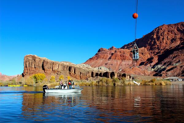
USGS scientists up on the cable way at Lees Ferry measuring suspended-sediment transport.
Images
Images
Filter Total Items: 9454
Suspended Scientists
USGS scientists up on the cable way at Lees Ferry measuring suspended-sediment transport.
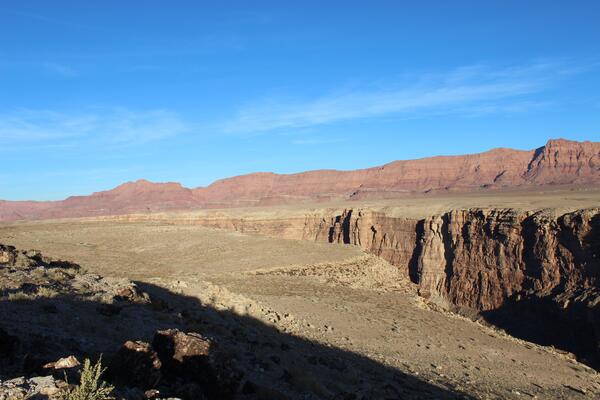
Beaver Creek Rapid
View of the landscape from the Beaver Creek Rapid lookout.
View of the landscape from the Beaver Creek Rapid lookout.

Gas Hydrates Research Project in Japan
Scientists from AIST, JOGMEC, Georgia Tech, and the USGS prepare to analyze pressure cores as part of a multi-year gas hydrates research project in Japan. Left to right: Carlos Santamarina (Georgia Tech) and David Mason (USGS).
Scientists from AIST, JOGMEC, Georgia Tech, and the USGS prepare to analyze pressure cores as part of a multi-year gas hydrates research project in Japan. Left to right: Carlos Santamarina (Georgia Tech) and David Mason (USGS).

Gas Hydrates Research Project in Japan
Scientists from AIST, JOGMEC, Georgia Tech, and the USGS prepare to analyze pressure cores as part of a multi-year gas hydrates research project in Japan. Left to right: Emile Bergeron (USGS), Kiyofumi Suzuki (JOGMEC), Marco Terzariol (Georgia Tech), William Waite (USGS), and Carlos Santamarina (Georgia Tech).
Scientists from AIST, JOGMEC, Georgia Tech, and the USGS prepare to analyze pressure cores as part of a multi-year gas hydrates research project in Japan. Left to right: Emile Bergeron (USGS), Kiyofumi Suzuki (JOGMEC), Marco Terzariol (Georgia Tech), William Waite (USGS), and Carlos Santamarina (Georgia Tech).

Gas Hydrates Research Project in Japan
Scientists from AIST, JOGMEC, Georgia Tech, and the USGS prepare to analyze pressure cores as part of a multi-year gas hydrates research project in Japan. Left to right: Yoshihiro Konno (AIST) and David Mason (USGS).
Scientists from AIST, JOGMEC, Georgia Tech, and the USGS prepare to analyze pressure cores as part of a multi-year gas hydrates research project in Japan. Left to right: Yoshihiro Konno (AIST) and David Mason (USGS).

Gas Hydrates Research Project in Japan
Scientists from AIST, JOGMEC, Georgia Tech, and the USGS prepare to analyze pressure cores as part of a multi-year gas hydrates research project in Japan. Front, left to right: Efthymios Papadopoulos (Georgia Tech) and Jun Yoneda (AIST).
Scientists from AIST, JOGMEC, Georgia Tech, and the USGS prepare to analyze pressure cores as part of a multi-year gas hydrates research project in Japan. Front, left to right: Efthymios Papadopoulos (Georgia Tech) and Jun Yoneda (AIST).

Gas Hydrates Research Project in Japan
Scientists from AIST, JOGMEC, Georgia Tech, and the USGS prepare to analyze pressure cores as part of a multi-year gas hydrates research project in Japan. Left to right: Emile Bergeron (USGS) and Carlos Santamarina (Georgia Tech) are preparing to use a cutter (center) to saw a pressure core into shorter-length sections for transfer into various test devices.
Scientists from AIST, JOGMEC, Georgia Tech, and the USGS prepare to analyze pressure cores as part of a multi-year gas hydrates research project in Japan. Left to right: Emile Bergeron (USGS) and Carlos Santamarina (Georgia Tech) are preparing to use a cutter (center) to saw a pressure core into shorter-length sections for transfer into various test devices.

Redoubt Volcano
Photo of Redoubt and vicinity taken from the gas/obs fixed-wing flight.
Photo of Redoubt and vicinity taken from the gas/obs fixed-wing flight.

Rockfishes Inhabit Oil Platforms
Rockfishes inhabit oil platforms offshore of California.
Rockfishes inhabit oil platforms offshore of California.

Sierra Nevada Yellow-Legged Frog
A Sierra Nevada yellow-legged frog (Rana sierrae) scans the landscape in Yosemite National Park.
A Sierra Nevada yellow-legged frog (Rana sierrae) scans the landscape in Yosemite National Park.

2013 Gas Hydrate Expedition in Gulf of Mexico
USGS technicians Ray Sliter, Pete Dal Ferro, and Tom O'Brien retrieve the 72-channel digital seismic streamer on the research vessel Pelican during a cruise to explore gas hydrates in the deepwater Gulf of Mexico from April to May, 2013.
USGS technicians Ray Sliter, Pete Dal Ferro, and Tom O'Brien retrieve the 72-channel digital seismic streamer on the research vessel Pelican during a cruise to explore gas hydrates in the deepwater Gulf of Mexico from April to May, 2013.

Black-Bellied Salamander
This black-bellied salamander (Desmognathus quadramaculatus) was found in the Citico Creek Wilderness, Cherokee National Forest, Tennessee.
This black-bellied salamander (Desmognathus quadramaculatus) was found in the Citico Creek Wilderness, Cherokee National Forest, Tennessee.

2013 Gas Hydrate Expedition in Gulf of Mexico
USGS technicians Eric Moore and Jenny White deploy instruments at the start of a seismic survey to explore gas hydrates in the deepwater Gulf of Mexico from April to May 2013.
USGS technicians Eric Moore and Jenny White deploy instruments at the start of a seismic survey to explore gas hydrates in the deepwater Gulf of Mexico from April to May 2013.

Great Lakes Beach Health
As schools close for the year and summer weather beckons, many recreationalists head to the Great Lakes' public beaches. However, these coastal areas can become contaminated with disease-causing bacteria that threaten public health, disrupt water recreation, and pay a toll on the Great Lakes economies that depend on summer tourism.
As schools close for the year and summer weather beckons, many recreationalists head to the Great Lakes' public beaches. However, these coastal areas can become contaminated with disease-causing bacteria that threaten public health, disrupt water recreation, and pay a toll on the Great Lakes economies that depend on summer tourism.

Assuring Water Availability and Quality in the US-Mexico Borderlands
Assuring Water Availability and Quality in the US-Mexico BorderlandsThe dry climate of the Borderlands increases the challenge of balancing water supplies between humans and ecosystems. Here, two horses and their riders observe the low water levels of a river.
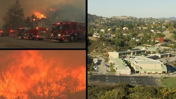
Southern California's Fire Landscape
A screenshot from the USGS film "Living with Fire".
USGS is investigating ways to balance community fire risk management and native habitat conservation as part of the USGS Southern California Wildfire Risk Scenario Project, analyzing both human factors and natural factors.
A screenshot from the USGS film "Living with Fire".
USGS is investigating ways to balance community fire risk management and native habitat conservation as part of the USGS Southern California Wildfire Risk Scenario Project, analyzing both human factors and natural factors.

Black-necked Stilt Male
Birds found in and around the Salton Sea, California.
Birds found in and around the Salton Sea, California.

Penobscot River Work - Station 2
This photo from our second cross section is an example of significant changes to the river. Data was collected from this location in 2009 from a manned boat, with no issue. Upon return to the same cross section in 2013 we found a 2-4 ft hydraulic feature exposed. Backwater from the Great Works Dam hid this feature previously.
This photo from our second cross section is an example of significant changes to the river. Data was collected from this location in 2009 from a manned boat, with no issue. Upon return to the same cross section in 2013 we found a 2-4 ft hydraulic feature exposed. Backwater from the Great Works Dam hid this feature previously.

Penobscot River Work - Station 4
A photo from August 2013 after removal of the Great Works Dam, showing the old concrete, wood and stone cribbing upstream of where the dam used to be.
A photo from August 2013 after removal of the Great Works Dam, showing the old concrete, wood and stone cribbing upstream of where the dam used to be.

Penobscot River Work - Station 4
A photo from August 2013 showing the cribbing upstream of where the dam used to be. See the photo titled 'Station 4 2009' for a picture from before the dam was removed from the same general perspective.
A photo from August 2013 showing the cribbing upstream of where the dam used to be. See the photo titled 'Station 4 2009' for a picture from before the dam was removed from the same general perspective.

Florida Panther
Florida panther; Puma concolor coryi, remains one of the most endangered mammals in the world.
Florida panther; Puma concolor coryi, remains one of the most endangered mammals in the world.