
A black carp collected from a lake in the middle Mississippi River in Alexander County, Illinois. Credit: U.S. Fish and Wildlife Service.
Images
Images
Filter Total Items: 9454
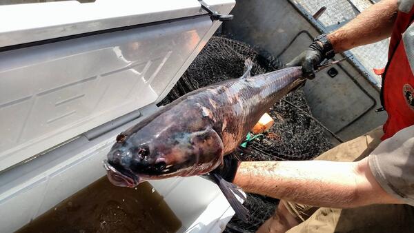
Black Carp in the Mississippi River
A black carp collected from a lake in the middle Mississippi River in Alexander County, Illinois. Credit: U.S. Fish and Wildlife Service.
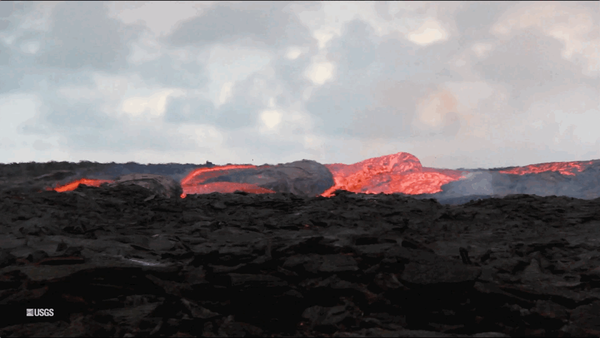
Kīlauea Volcano — Lava Flow (GIF)
An animated GIF showing lava bubbling out of fissure 8 at Kīlauea Volcano, Hawaii. Clip is taken from the full b-roll video listed as the source.
An animated GIF showing lava bubbling out of fissure 8 at Kīlauea Volcano, Hawaii. Clip is taken from the full b-roll video listed as the source.

Kilauea Volcano -- Lower East Rift Zone lava flows and fissures
Kilauea Volcano -- Lower East Rift Zone lava flows and fissuresMap as of 10:00 a.m. HST, June 15, 2018.

technician processing a water sample
U.S. Geological Survey laboratory technician at the Baton Rouge Sediment Laboratory processing a water sample with the modified riffle splitter used to analyze cooperative program samples (photograph by Aimee Downs, U.S. Geological Survey).
SIR 2018-5147
U.S. Geological Survey laboratory technician at the Baton Rouge Sediment Laboratory processing a water sample with the modified riffle splitter used to analyze cooperative program samples (photograph by Aimee Downs, U.S. Geological Survey).
SIR 2018-5147

Conte Lab scientists guide American shad
Sam Parker, Kevin Molongoski and Steve Walk, USGS scientists, use nets to guide American shad into a study area during a shad fishway entrance gate study at the S.O. Conte Research Laboratory in Turners Falls, Massachusetts, June 1, 2018. USGS photo by Andrea Miehls.
Sam Parker, Kevin Molongoski and Steve Walk, USGS scientists, use nets to guide American shad into a study area during a shad fishway entrance gate study at the S.O. Conte Research Laboratory in Turners Falls, Massachusetts, June 1, 2018. USGS photo by Andrea Miehls.

Conte Lab scientists transfer shad
Sam Parker and Kevin Molongoski, USGS scientists, transfer American shad from the study area to a tank on a fish truck before being released in the Connecticut River following a shad fishway entrance gate study at the S.O. Conte Research Laboratory in Turners Falls, Massachusetts, June 1, 2018. USGS photo by Andrea Miehls.
Sam Parker and Kevin Molongoski, USGS scientists, transfer American shad from the study area to a tank on a fish truck before being released in the Connecticut River following a shad fishway entrance gate study at the S.O. Conte Research Laboratory in Turners Falls, Massachusetts, June 1, 2018. USGS photo by Andrea Miehls.

Pele's Hair
This long thin, strand of volcanic glass is called Pele's hair. Named for Pele, the Hawaiian goddess of fire, Pele's hair is formed from lava fountains and rapidly moving lava flows. This strand of Pele’s hair was found on Kupono Street in Leilani Estates, Hawaii, during the Kīlauea volcano eruption.
This long thin, strand of volcanic glass is called Pele's hair. Named for Pele, the Hawaiian goddess of fire, Pele's hair is formed from lava fountains and rapidly moving lava flows. This strand of Pele’s hair was found on Kupono Street in Leilani Estates, Hawaii, during the Kīlauea volcano eruption.
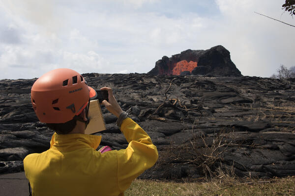
A volcanologist observes a lava fountain during the 2018 Kilauea eruption
A volcanologist observes a lava fountain during the 2018 Kilauea eruptionU.S. Geological Survey Volcanologist Matthew Patrick photographs and observes a lava fountain in the Leilani Estates near Hilo, Hawai`i on Sunday, May 27, 2018.

Fountaining fissure documentation at the Kilauea eruption
Fountaining fissure documentation at the Kilauea eruptionUSGS scientist in the Lower East Rift Zone documenting the spectacular ~50 m tall fissure 7 lava fountain to the east which had lit up the sky in a red hue.
Fountaining fissure documentation at the Kilauea eruption
Fountaining fissure documentation at the Kilauea eruptionUSGS scientist in the Lower East Rift Zone documenting the spectacular ~50 m tall fissure 7 lava fountain to the east which had lit up the sky in a red hue.
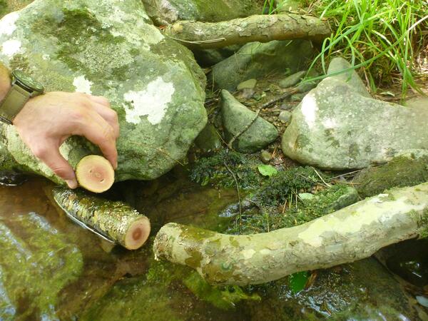
Root cookie next to the place where it was cut
A root cookie and the place in the root where it was cut. Root cookies can be used to estimate rates of stream bank erosion.
A root cookie and the place in the root where it was cut. Root cookies can be used to estimate rates of stream bank erosion.

Lava fountains from Fissure 20
Lava fountains from Fissure 20 cover residential neighborhoods and farmland in Kīlauea Volcano's lower East Rift Zone (Hawaii). The USGS Hawaiian Volcano Observatory tracked eruptive activity and provided updates to emergency officials. Photo taken May 19, 2018, by Elise Rumpf.
Lava fountains from Fissure 20 cover residential neighborhoods and farmland in Kīlauea Volcano's lower East Rift Zone (Hawaii). The USGS Hawaiian Volcano Observatory tracked eruptive activity and provided updates to emergency officials. Photo taken May 19, 2018, by Elise Rumpf.

5/12/18, 12:57 p.m. HST - Lava was slowly advancing from fissure 16.
5/12/18, 12:57 p.m. HST - Lava was slowly advancing from fissure 16.5/12/18, 12:57 p.m. HST - Lava was slowly advancing from fissure 16.
5/12/18, 12:57 p.m. HST - Lava was slowly advancing from fissure 16.
5/12/18, 12:57 p.m. HST - Lava was slowly advancing from fissure 16.5/12/18, 12:57 p.m. HST - Lava was slowly advancing from fissure 16.

An aerial view of fissure 16
5/12/18, 08:27 a.m. HST - An aerial view of fissure 16, located about 1.3 km (0.8 miles) northeast of fissure 15 (top left). The fissure is located 500 m northeast of the Puna Geothermal Venture site (top right). Photograph courtesy of Hawai`i County Fire Department.
5/12/18, 08:27 a.m. HST - An aerial view of fissure 16, located about 1.3 km (0.8 miles) northeast of fissure 15 (top left). The fissure is located 500 m northeast of the Puna Geothermal Venture site (top right). Photograph courtesy of Hawai`i County Fire Department.

An ash plume rose from the Overlook crater at Kīlauea's summit.
An ash plume rose from the Overlook crater at Kīlauea's summit.
Ash column rises from the Overlook crater at the summit of Kīlauea Vol
Ash column rises from the Overlook crater at the summit of Kīlauea VolAsh column rises from the Overlook crater at the summit of Kīlauea Volcano. HVO's interpretation is that the explosion was triggered by a rockfall from the steep walls of Overlook crater. The photograph was taken 5/9/18 at 8:29 a.m. HST from the Jaggar Museum overlook.

HVO geologist measures temperature on Nohea Street
HVO geologist measures temperature on Nohea StreetHVO geologist measured a temperature of 103 degrees C (218 degree F) at a crack along Nohea Street, Leilani Estates. The asphalt road was describes as "mushy" from the heat.
HVO geologist measures temperature on Nohea Street
HVO geologist measures temperature on Nohea StreetHVO geologist measured a temperature of 103 degrees C (218 degree F) at a crack along Nohea Street, Leilani Estates. The asphalt road was describes as "mushy" from the heat.

Yellow street lines show the offset of cracks on Leilani Street.
Yellow street lines show the offset of cracks on Leilani Street.Yellow street lines show the offset of cracks on Leilani Street, Leilani Estates.
Yellow street lines show the offset of cracks on Leilani Street.
Yellow street lines show the offset of cracks on Leilani Street.Yellow street lines show the offset of cracks on Leilani Street, Leilani Estates.

Severe ground cracks associated with fissure 14 in Leilani Estates.
Severe ground cracks associated with fissure 14 in Leilani Estates.Severe ground cracks associated with fissure 14 in Leilani Estates.
Severe ground cracks associated with fissure 14 in Leilani Estates.
Severe ground cracks associated with fissure 14 in Leilani Estates.Severe ground cracks associated with fissure 14 in Leilani Estates.

Kanakee River at Davis, IN - downstream of channel
Kanakee River at Davis, IN - downstream of channelKanakee River at Davis, IN - downstream of channel
Kanakee River at Davis, IN - downstream of channel
Kanakee River at Davis, IN - downstream of channelKanakee River at Davis, IN - downstream of channel

Great Dismal Swamp
Scientists are collecting core samples from the Great Dismal Swamp in Virginia to understand natural conditions before centuries of ditching, draining and harvesting. This is a collaborative project between the USGS and the Great Dismal Swamp National Wildlife Refuge.
Scientists are collecting core samples from the Great Dismal Swamp in Virginia to understand natural conditions before centuries of ditching, draining and harvesting. This is a collaborative project between the USGS and the Great Dismal Swamp National Wildlife Refuge.

The Great Dismal Swamp
Photograph of the Great Dismal Swamp in Virginia.
Photograph of the Great Dismal Swamp in Virginia.