Groundwater sampling equipment at AY-68-27-610 (Parkwood Park).
Groundwater sampling equipment at AY-68-27-610 (Parkwood Park).Back cover photo from

Official websites use .gov
A .gov website belongs to an official government organization in the United States.
Secure .gov websites use HTTPS
A lock () or https:// means you’ve safely connected to the .gov website. Share sensitive information only on official, secure websites.
Images

Back cover photo from

Is this cemetery haunted? Probably not, but there could be tiny things moving beyond the grave. The USGS sampled groundwater downhill of Mt. Hope Cemetery in Lansing, Michigan, to find out if materials associated with decomposition and burial processes could affect groundwater quality near a cemetery.
Is this cemetery haunted? Probably not, but there could be tiny things moving beyond the grave. The USGS sampled groundwater downhill of Mt. Hope Cemetery in Lansing, Michigan, to find out if materials associated with decomposition and burial processes could affect groundwater quality near a cemetery.
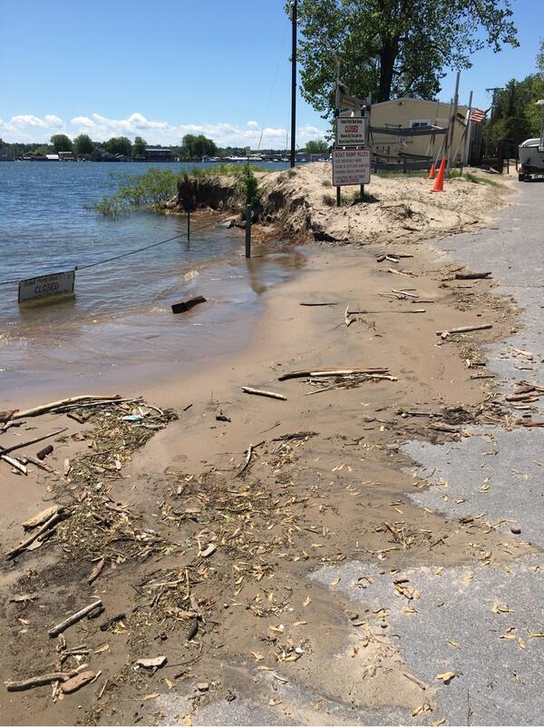
As floodwaters recede, USGS scientists document high water marks, which include debris carried by flood water. The USGS Flood Inundation Mapper incorporates data about past flooding on Lake Ontario’s New York shoreline, including high water marks. Photo by Jared Marion, USGS.
As floodwaters recede, USGS scientists document high water marks, which include debris carried by flood water. The USGS Flood Inundation Mapper incorporates data about past flooding on Lake Ontario’s New York shoreline, including high water marks. Photo by Jared Marion, USGS.

USGS technicians prepare to board a boat to go out to the center of the channel in the San Joaquin River below Friant Dam to get an accurate measurement of water flow during releases from the Dam for flood control.
USGS technicians prepare to board a boat to go out to the center of the channel in the San Joaquin River below Friant Dam to get an accurate measurement of water flow during releases from the Dam for flood control.

This image shows a sea lamprey in its larvae phase.
This image shows a sea lamprey in its larvae phase.

Green sea turtles are listed as threatened or endangered throughout their range. (Credit: Thierry Work, USGS)
Green sea turtles are listed as threatened or endangered throughout their range. (Credit: Thierry Work, USGS)
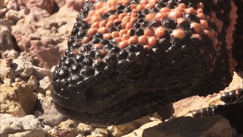
Gila monsters are one of only two venomous lizard species in the world. They live in the southwestern U.S. and in Mexico. This animated GIF comes from a video that short features USGS Emeritus Research Ecologist, Cecil Schwalbe describing details of Gila monster biology and ecology and how he survived a very painful Gila monster bite.
Gila monsters are one of only two venomous lizard species in the world. They live in the southwestern U.S. and in Mexico. This animated GIF comes from a video that short features USGS Emeritus Research Ecologist, Cecil Schwalbe describing details of Gila monster biology and ecology and how he survived a very painful Gila monster bite.

This photomicrograph shows a liver of a frog with a severe Perkinsea infection.
This photomicrograph shows a liver of a frog with a severe Perkinsea infection.

Bill Schulz, USGS Research Geologist, takes photographs of Puerto Rican hillsides from a U.S. Army helicopter to document landslides caused by Hurricane Maria.
Bill Schulz, USGS Research Geologist, takes photographs of Puerto Rican hillsides from a U.S. Army helicopter to document landslides caused by Hurricane Maria.

Coral reefs are prone to phase shifts where they quickly transition from coral-dominated to a uniformity of other organisms, typically algae. The Palmyra Atoll National Wildlife Refuge in the Central Pacific is a unique case where a transition from corals to corallimorphs occurred.
Coral reefs are prone to phase shifts where they quickly transition from coral-dominated to a uniformity of other organisms, typically algae. The Palmyra Atoll National Wildlife Refuge in the Central Pacific is a unique case where a transition from corals to corallimorphs occurred.

Photograph from page 19 of

A male lesser scaup at the USGS Eastern Ecological Science Center in Maryland. This bird was not part of this new research. Photograph taken in 2017. Credit: Jeffrey Sullivan, USGS.
A male lesser scaup at the USGS Eastern Ecological Science Center in Maryland. This bird was not part of this new research. Photograph taken in 2017. Credit: Jeffrey Sullivan, USGS.

USGS technician measuring streamflow in the Sisquoc River near Garey, California, upstream of the Santa Maria Mesa Road Bridge.
USGS technician measuring streamflow in the Sisquoc River near Garey, California, upstream of the Santa Maria Mesa Road Bridge.

USGS Streamgaging equipment and cableway on the Pit River near Canby, California operates year round.
USGS Streamgaging equipment and cableway on the Pit River near Canby, California operates year round.

A little brown bat (Myotis lucifugus) with white-nose syndrome hibernating in a Virginia cave during late spring of 2016.
A little brown bat (Myotis lucifugus) with white-nose syndrome hibernating in a Virginia cave during late spring of 2016.

This USGS Rapid Deployment Gauge was installed near Morovis, Puerto Rico, to monitor the Río Grande de Manatí after Hurricane Maria destroyed the permanent streamgage which typically monitors the river. USGS photo.
This USGS Rapid Deployment Gauge was installed near Morovis, Puerto Rico, to monitor the Río Grande de Manatí after Hurricane Maria destroyed the permanent streamgage which typically monitors the river. USGS photo.

Permafrost forms a grid-like pattern in the National Petroleum Reserve-Alaska, a 22.8 million acre region managed by the Bureau of Land Management on Alaska's North Slope. USGS has periodically assessed oil and gas resource potential there. These assessments can be found here.
Permafrost forms a grid-like pattern in the National Petroleum Reserve-Alaska, a 22.8 million acre region managed by the Bureau of Land Management on Alaska's North Slope. USGS has periodically assessed oil and gas resource potential there. These assessments can be found here.

Coral reefs are prone to phase shifts where they quickly transition from coral-dominated to a uniformity of other organisms, typically algae. The Palmyra Atoll National Wildlife Refuge in the Central Pacific is a unique case where a transition from corals to corallimorphs occurred.
Coral reefs are prone to phase shifts where they quickly transition from coral-dominated to a uniformity of other organisms, typically algae. The Palmyra Atoll National Wildlife Refuge in the Central Pacific is a unique case where a transition from corals to corallimorphs occurred.

Back cover photo from

Back cover photo from

Cover background photo from
Cover background photo from