
Two views from the Rainbow Falls overlook, downstream of the Wailuku River streamgage near Hilo, Hawaii. The image on the left shows a typical base flow of about 35 cubic feet per second (cfs). The image on the right shows the early impact of Hurricane Lane with a flow of about 26,000 cfs taken at 8:35 a.m. HST, August 23, 2018. This U.S.
Images
Images
Filter Total Items: 9449

Impact of Hurricane Lane on Wailuku River
Two views from the Rainbow Falls overlook, downstream of the Wailuku River streamgage near Hilo, Hawaii. The image on the left shows a typical base flow of about 35 cubic feet per second (cfs). The image on the right shows the early impact of Hurricane Lane with a flow of about 26,000 cfs taken at 8:35 a.m. HST, August 23, 2018. This U.S.
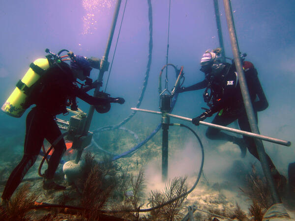
USGS scientists drill a coral-reef core in the Florida Keys
USGS scientists drill a coral-reef core in the Florida KeysResearch Oceanographer Lauren Toth and student volunteer Liz Whitcher drill a coral-reef core from a reef off Key West, Florida, in the Florida Keys National Marine Sanctuary. Photo taken under research permit FKNMS-2015-058. Credit: Anastasios Stathakopoulos, USGS.

Scientific crew and drone operators
Scientific crew and drone operators. Left to right: Richard Kolyer (NASA), Jack McFarland (USGS), Kristen Manies (USGS), and Jonas Jonsson (NASA)
Scientific crew and drone operators. Left to right: Richard Kolyer (NASA), Jack McFarland (USGS), Kristen Manies (USGS), and Jonas Jonsson (NASA)

The Bay Bridge and the Oakland city skyline
The nighttime Oakland city skyline as seen from San Francisco with the Bay Bridge in the foreground
The nighttime Oakland city skyline as seen from San Francisco with the Bay Bridge in the foreground

Methane drone hovering above permafrost
Looking up at a drone hovering near an open-path methane analyzer mounted on a flux tower. Instruments mounted on both the towers and on the drones are measuring gases emitted from the soil.
Looking up at a drone hovering near an open-path methane analyzer mounted on a flux tower. Instruments mounted on both the towers and on the drones are measuring gases emitted from the soil.

GeoGirls_Sediment2
GeoGirls analyze volcanic sediment at the Coldwater Lake outlet.
GeoGirls analyze volcanic sediment at the Coldwater Lake outlet.

GeoGirls_Core
GeoGirls take core samples at a pond near the Hummocks Trail to study groundwater transport.
GeoGirls take core samples at a pond near the Hummocks Trail to study groundwater transport.

GeoGirls Examing Tephra Deposits
The GeoGirls examined tephra (ash and pumice) deposits from Mount St. Helens’ eruptive past and learned how to create a stratigraphic column.
The GeoGirls examined tephra (ash and pumice) deposits from Mount St. Helens’ eruptive past and learned how to create a stratigraphic column.

Western Bumble Bee
Many bumble bee species have declined in recent decades due to changes in habitat, climate, and pressures from pathogens, pesticides and introduced species. The western bumble bee, once common throughout western North America, is a species of concern and is being considered for listing by the U.S. Fish and Wildlife Service under the Endangered Species Act.
Many bumble bee species have declined in recent decades due to changes in habitat, climate, and pressures from pathogens, pesticides and introduced species. The western bumble bee, once common throughout western North America, is a species of concern and is being considered for listing by the U.S. Fish and Wildlife Service under the Endangered Species Act.

Yellow Creek near Oak Grove, IN
Yellow Creek near Oak Grove, IN

Like many Keys corals, this one has no new growth
A modern coral reef in Dry Tortugas National Park. There is little living coral and high rates of bioerosion. Photo taken under research permit number DRTO-2018-SCI-0005. Credit: Lauren Toth, USGS
A modern coral reef in Dry Tortugas National Park. There is little living coral and high rates of bioerosion. Photo taken under research permit number DRTO-2018-SCI-0005. Credit: Lauren Toth, USGS

Backcountry travel in Grand Canyon to collect groundwater samples
Backcountry travel in Grand Canyon to collect groundwater samplesUSGS scientist Nick Voichick rafted about 150 miles in nine days on the Grand Canyon portion of the Colorado River to collect groundwater samples from springs in remote locations.

Backcountry travel in Grand Canyon to collect groundwater samples
Backcountry travel in Grand Canyon to collect groundwater samplesUSGS scientists Tom Porter and Joel Unema warm up in the sun as the scientific expedition moves downstream to the next sample location.
Backcountry travel in Grand Canyon to collect groundwater samples
Backcountry travel in Grand Canyon to collect groundwater samplesUSGS scientists Tom Porter and Joel Unema warm up in the sun as the scientific expedition moves downstream to the next sample location.

Backcountry Travel for Science
USGS scientists Kim Besiner, John Solder and Kate Wilkins collect groundwater samples at Grapevine Main Spring.
Scientists traveled to the remote locations along the south rim of the Grand Canyon to assess the potential effects of mining along the Coconino Plateau and groundwater withdrawals associated with increasing populations.

Backcountry travel in Grand Canyon to collect groundwater samples
Backcountry travel in Grand Canyon to collect groundwater samplesUSGS scientist Joel Unema hikes to National Canyon Spring to collect groundwater samples from a remote location near the south rim of the Grand Canyon. Joel Unema was part of a group of USGS and National Park Service scientists that rafted 150 miles in nine days to better understand natural resources.

Backcountry Travel for Science
A group of USGS and National Park Service scientists above Granite Gorge on route for 56 miles and 20,000 vertical feet along the south rim of the Grand Canyon to collect groundwater samples from three springs.
Scientists in this photo (left to right) are Christina Bryant, Kim Beisner, John Solder and Kate Wilkins.
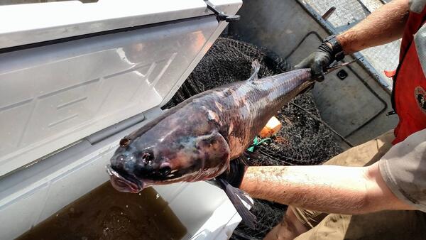
Black Carp in the Mississippi River
A black carp collected from a lake in the middle Mississippi River in Alexander County, Illinois. Credit: U.S. Fish and Wildlife Service.
A black carp collected from a lake in the middle Mississippi River in Alexander County, Illinois. Credit: U.S. Fish and Wildlife Service.
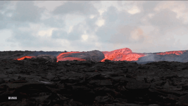
Kīlauea Volcano — Lava Flow (GIF)
An animated GIF showing lava bubbling out of fissure 8 at Kīlauea Volcano, Hawaii. Clip is taken from the full b-roll video listed as the source.
An animated GIF showing lava bubbling out of fissure 8 at Kīlauea Volcano, Hawaii. Clip is taken from the full b-roll video listed as the source.

Kilauea Volcano -- Lower East Rift Zone lava flows and fissures
Kilauea Volcano -- Lower East Rift Zone lava flows and fissuresMap as of 10:00 a.m. HST, June 15, 2018.

technician processing a water sample
U.S. Geological Survey laboratory technician at the Baton Rouge Sediment Laboratory processing a water sample with the modified riffle splitter used to analyze cooperative program samples (photograph by Aimee Downs, U.S. Geological Survey).
SIR 2018-5147
U.S. Geological Survey laboratory technician at the Baton Rouge Sediment Laboratory processing a water sample with the modified riffle splitter used to analyze cooperative program samples (photograph by Aimee Downs, U.S. Geological Survey).
SIR 2018-5147

Conte Lab scientists guide American shad
Sam Parker, Kevin Molongoski and Steve Walk, USGS scientists, use nets to guide American shad into a study area during a shad fishway entrance gate study at the S.O. Conte Research Laboratory in Turners Falls, Massachusetts, June 1, 2018. USGS photo by Andrea Miehls.
Sam Parker, Kevin Molongoski and Steve Walk, USGS scientists, use nets to guide American shad into a study area during a shad fishway entrance gate study at the S.O. Conte Research Laboratory in Turners Falls, Massachusetts, June 1, 2018. USGS photo by Andrea Miehls.