
Cattle graze on a ranch in western Montana.
Images
Images
Filter Total Items: 9449

Cattle Grazing at Sunset in Montana

Elk Feedgrounds
Elk grazing at a feedground in Wyoming.
Elk grazing at a feedground in Wyoming.

Flooding near Houston, Texas on April 20, 2016
USGS responsds to recent flooding near Houston, Texas on April 20, 2016.
USGS responsds to recent flooding near Houston, Texas on April 20, 2016.

Blue Shiner, Cyprinella caerulea
Blue Shiner, Cyprinella caerulea

Field Work - Scientists and Air-Quality Monitoring
Field Work - Scientists and Air-Quality MonitoringAlaska Volcano Observatory scientist Mark Hansen working with Larsen Bay Mayor David Harmes on how the AVO-4 particulate monitor operates.
Field Work - Scientists and Air-Quality Monitoring
Field Work - Scientists and Air-Quality MonitoringAlaska Volcano Observatory scientist Mark Hansen working with Larsen Bay Mayor David Harmes on how the AVO-4 particulate monitor operates.

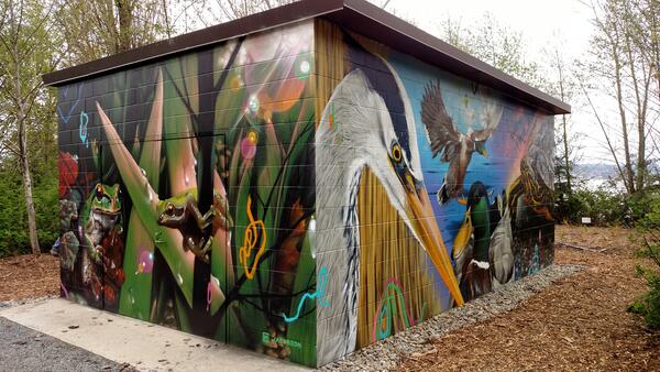
Murals on the USGS Western Fisheries Research Center Pump House
Murals on the USGS Western Fisheries Research Center Pump HouseMurals on the USGS Western Fisheries Research Center Pump House structure by Jeff Jacobson.
Murals on the USGS Western Fisheries Research Center Pump House
Murals on the USGS Western Fisheries Research Center Pump HouseMurals on the USGS Western Fisheries Research Center Pump House structure by Jeff Jacobson.
USGS Western Fisheries Research Structure Pump House structure
USGS Western Fisheries Research Structure Pump House structureMurals on the USGS Western Fisheries Research Structure Pump House structure by Jeff Jacobson.
USGS Western Fisheries Research Structure Pump House structure
USGS Western Fisheries Research Structure Pump House structureMurals on the USGS Western Fisheries Research Structure Pump House structure by Jeff Jacobson.

Interpretive signage for USGS Western Fisheries Research Center Pump House
Interpretive signage for USGS Western Fisheries Research Center Pump HouseInterpretive signage created by interpretive designer and illustrator Denise Dahn, with murals of USGS Western Fisheries Research Center Pump House created by Jeff Jacobson in background.

Early USGS streamgage in Texas
Looking upstream from gage site at Trinity River at Commerce Street Bridge.
Looking upstream from gage site at Trinity River at Commerce Street Bridge.

USGS streamgage in 1940 near Derby, Texas
In the earlier years of streamgaging, large “stilling wells” were constructed to contain the equipment needed to collect streamflow data. Historically, most of the streamflow equipment may have been located in these large structures, which were placed in the middle or next to the stream.
In the earlier years of streamgaging, large “stilling wells” were constructed to contain the equipment needed to collect streamflow data. Historically, most of the streamflow equipment may have been located in these large structures, which were placed in the middle or next to the stream.
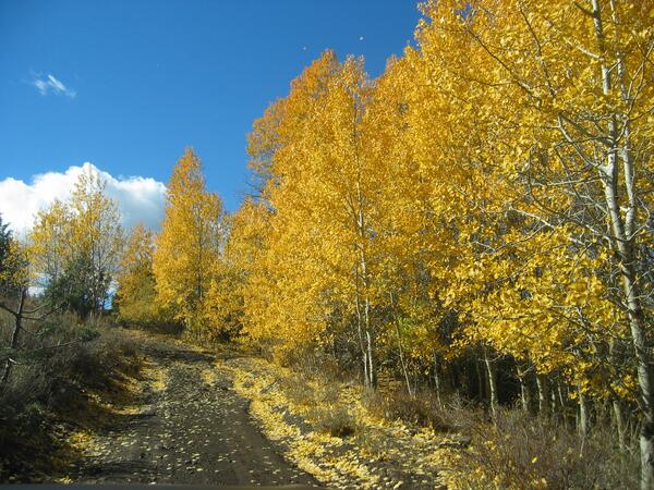
Reynolds Creek Experimental Watershed
Aspen trees at the Reynolds Creek experimental watershed in Idaho.
Aspen trees at the Reynolds Creek experimental watershed in Idaho.

USGS Streamgage near Derby, Texas
Currently, most of the streamflow equipment is located on a streambank or bridge. Large structures are no longer needed at most streamgage locations. Today, streamgage equipment can be contained in small metal shelters that are located on streambanks or bridges.
Currently, most of the streamflow equipment is located on a streambank or bridge. Large structures are no longer needed at most streamgage locations. Today, streamgage equipment can be contained in small metal shelters that are located on streambanks or bridges.

USGS Streamgage in Dallas, Texas
This 2014 photo shows the new location of the USGS streamgage that measures high flows on the Trinity River in Dallas. The gage was once located on a pier, but in 1975 was moved next to the stream.
This 2014 photo shows the new location of the USGS streamgage that measures high flows on the Trinity River in Dallas. The gage was once located on a pier, but in 1975 was moved next to the stream.

Construction of a USGS streamgage in 1939
Construction in 1939 of a streamgage structure at Elm Fork Trinity River near Carrollton, Texas.
Construction in 1939 of a streamgage structure at Elm Fork Trinity River near Carrollton, Texas.

Oldest version of a USGS streamgage in Texas
One of the oldest versions of a streamgage structure constructed in Texas.
One of the oldest versions of a streamgage structure constructed in Texas.

Oldest version of a USGS streamgage in Texas
A close-up view of the top part of one of the oldest streamgage structures constructed in Texas.
A close-up view of the top part of one of the oldest streamgage structures constructed in Texas.

USGS Streamgage near Carrollton, Texas.
Modern-day USGS streamgage at Elm Fork Trinity River near Carrollton, Texas.
Modern-day USGS streamgage at Elm Fork Trinity River near Carrollton, Texas.

USGS Streamgage near Junction, Texas
A modern 21st century version of a streamgage structure.
A modern 21st century version of a streamgage structure.

1955 USGS streamgage near Carrollton, Texas
Nearly completed construction of a streamgage structure in 1955 at Elm Fork Trinity River near Carollton, Texas.
Nearly completed construction of a streamgage structure in 1955 at Elm Fork Trinity River near Carollton, Texas.

Early USGS streamgage in Dallas, Texas
This 1922 photo shows an early USGS streamgage on the Trinity River in Dallas.
This 1922 photo shows an early USGS streamgage on the Trinity River in Dallas.

Photomicrograph of rock thin section: Gabbroic inclusion
Photomicrograph of rock thin section: Gabbroic inclusionPhotomicrograph of gabbroic inclusion in Ogres Brow basaltic andesite. A rock thin section is created by gluing a small piece of rock onto a glass slide, then grinding it down to a thickness of 30 microns (the average human hair is about 100 microns in diameter) so that light shines through it when examined under the microscope.