Drought-related tree mortality in Sequoia National Park
Drought-related tree mortality in Sequoia National ParkDrought-related tree mortality at a low elevation forest in Sequoia National Park.

Official websites use .gov
A .gov website belongs to an official government organization in the United States.
Secure .gov websites use HTTPS
A lock () or https:// means you’ve safely connected to the .gov website. Share sensitive information only on official, secure websites.
Images

Drought-related tree mortality at a low elevation forest in Sequoia National Park.
Drought-related tree mortality at a low elevation forest in Sequoia National Park.

In this image, a helicopter towing a large, cylindrical sensor makes low-level flights as part of a USGS remote geophysical survey, which collects data about underground geology. The scientific system, called Resolve, is operated by CGG Canada Services, Ltd.
In this image, a helicopter towing a large, cylindrical sensor makes low-level flights as part of a USGS remote geophysical survey, which collects data about underground geology. The scientific system, called Resolve, is operated by CGG Canada Services, Ltd.

Aerial view showing the intense greenup of restoration plots in the lower Colorado River Delta following the 2014 Minute 319 pulse flow.
Aerial view showing the intense greenup of restoration plots in the lower Colorado River Delta following the 2014 Minute 319 pulse flow.
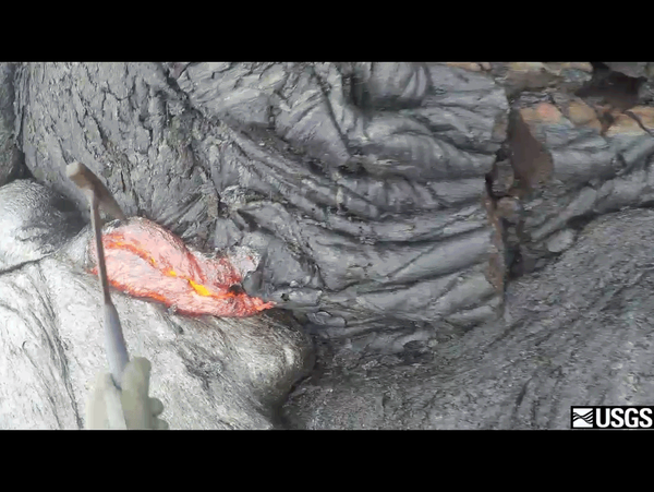
This is an animated GIF, taken from a longer video, showing the moment that this geologist from the Hawaiian Volcano Observatory (HVO) scoops up lava from an active flow and drops it into a bucket of water to cool it down.
This is an animated GIF, taken from a longer video, showing the moment that this geologist from the Hawaiian Volcano Observatory (HVO) scoops up lava from an active flow and drops it into a bucket of water to cool it down.

USGS hydrologist Mark Reid looks at one of the many grabens (extensional basins) that formed as the Oso landslide swept across the North Fork Stillaguamish River valley.
USGS hydrologist Mark Reid looks at one of the many grabens (extensional basins) that formed as the Oso landslide swept across the North Fork Stillaguamish River valley.

Family group (adult female and cub-of-the-year) photographed in September of 2015 departing the bowhead whale bone pile near the community of Kaktovik, AK.
Family group (adult female and cub-of-the-year) photographed in September of 2015 departing the bowhead whale bone pile near the community of Kaktovik, AK.

Low stream flows at USGS Wabuska stream gage (10301500) on the Walker River in Nevada, near the end of the 2011-2016 drought. Link to streamgage data.
Low stream flows at USGS Wabuska stream gage (10301500) on the Walker River in Nevada, near the end of the 2011-2016 drought. Link to streamgage data.

Hoover Dam looking upstream on the Colorado River.
Hoover Dam looking upstream on the Colorado River.

USGS scientists drilling a research core near Waco, Texas. This core was drilled by USGS during field work for an oil and gas assessment for the Eagle Ford of the Gulf Coast Basins. Cores like these provide information on the various rock layers, such as their make-up, their age, etc.
USGS scientists drilling a research core near Waco, Texas. This core was drilled by USGS during field work for an oil and gas assessment for the Eagle Ford of the Gulf Coast Basins. Cores like these provide information on the various rock layers, such as their make-up, their age, etc.

USGS scientists drilling a research core near Waco, Texas. This core was drilled by USGS during field work for an oil and gas assessment for the Eagle Ford of the Gulf Coast Basins. Cores like these provide information on the various rock layers, such as their make-up, their age, etc.
USGS scientists drilling a research core near Waco, Texas. This core was drilled by USGS during field work for an oil and gas assessment for the Eagle Ford of the Gulf Coast Basins. Cores like these provide information on the various rock layers, such as their make-up, their age, etc.

USGS scientists drilling a research core near Waco, Texas. This core was drilled by USGS during field work for an oil and gas assessment for the Eagle Ford of the Gulf Coast Basins. Cores like these provide information on the various rock layers, such as their make-up, their age, etc.
USGS scientists drilling a research core near Waco, Texas. This core was drilled by USGS during field work for an oil and gas assessment for the Eagle Ford of the Gulf Coast Basins. Cores like these provide information on the various rock layers, such as their make-up, their age, etc.

USGS scientist tests groundwater samples for water quality.
USGS scientist tests groundwater samples for water quality.

USGS scientists drilling a research core near Waco, Texas. This core was drilled by USGS during field work for an oil and gas assessment for the Eagle Ford of the Gulf Coast Basins. Cores like these provide information on the various rock layers, such as their make-up, their age, etc.
USGS scientists drilling a research core near Waco, Texas. This core was drilled by USGS during field work for an oil and gas assessment for the Eagle Ford of the Gulf Coast Basins. Cores like these provide information on the various rock layers, such as their make-up, their age, etc.

Salt-encrusted remains of a southwestern pond turtle (Actinemys pallida) as found in the dry lake bed of Elizabeth Lake, Los Angeles County, California. Note the heavy coating of evaporites on the carcass. Most living turtles collected in 2014 had similar but varying degrees of coatings on the head, limbs and shell.
Salt-encrusted remains of a southwestern pond turtle (Actinemys pallida) as found in the dry lake bed of Elizabeth Lake, Los Angeles County, California. Note the heavy coating of evaporites on the carcass. Most living turtles collected in 2014 had similar but varying degrees of coatings on the head, limbs and shell.

USGS scientists drilling a research core near Waco, Texas. This core was drilled by USGS during field work for an oil and gas assessment for the Eagle Ford of the Gulf Coast Basins. Cores like these provide information on the various rock layers, such as their make-up, their age, etc.
USGS scientists drilling a research core near Waco, Texas. This core was drilled by USGS during field work for an oil and gas assessment for the Eagle Ford of the Gulf Coast Basins. Cores like these provide information on the various rock layers, such as their make-up, their age, etc.

USGS scientists drilling a research core near Waco, Texas. This core was drilled by USGS during field work for an oil and gas assessment for the Eagle Ford of the Gulf Coast Basins. Cores like these provide information on the various rock layers, such as their make-up, their age, etc.
USGS scientists drilling a research core near Waco, Texas. This core was drilled by USGS during field work for an oil and gas assessment for the Eagle Ford of the Gulf Coast Basins. Cores like these provide information on the various rock layers, such as their make-up, their age, etc.

This assortment of sample bottles will be filled with groundwater and sent off to several labs for analyses that will describe the quality of the water.
This assortment of sample bottles will be filled with groundwater and sent off to several labs for analyses that will describe the quality of the water.

Photograph of Elizabeth Lake in the fourth year of drought and two years after the Powerhouse Fire. Note salt encrustation of surface and small accumulations of water remaining in the foreground and background.
Almost all of the turtles living in a southern California lake died following a large fire and years of drought, according to a new USGS report.

USGS scientists drilling a research core near Waco, Texas. This core was drilled by USGS during field work for an oil and gas assessment for the Eagle Ford of the Gulf Coast Basins. Cores like these provide information on the various rock layers, such as their make-up, their age, etc.
USGS scientists drilling a research core near Waco, Texas. This core was drilled by USGS during field work for an oil and gas assessment for the Eagle Ford of the Gulf Coast Basins. Cores like these provide information on the various rock layers, such as their make-up, their age, etc.

USGS crews are taking measurements following a flash flood event in Hildale, Utah.
USGS crews are taking measurements following a flash flood event in Hildale, Utah.

USGS scientist Brad Slaugh measures streamflow following a flash flood event in Hildale, Utah.
USGS scientist Brad Slaugh measures streamflow following a flash flood event in Hildale, Utah.