
This animated GIF is a map of the United States and its territories shows geographic extent of planned, existing, and in-progress 3DEP data acquisition projects by year.
How do I report errors in 3D Elevation Program (3DEP) elevation data?
If you think you’ve found an error in USGS elevation data, please send an email to tnm_help@usgs.gov. We will add the reported information to our "Digital Elevation Model Issues" data log for further analysis and possible correction.
Spikes, pits, seam-line anomalies, and other data errors are of concern to us. We are working to correct or minimize known issues, but it will take some time. Errors might not be fixed until new LIDAR or IFSAR is collected over the area.
Related

What is a digital elevation model (DEM)? What is a digital elevation model (DEM)?
A Digital Elevation Model (DEM) is a representation of the bare ground (bare earth) topographic surface of the Earth excluding trees, buildings, and any other surface objects. DEMs are created from a variety of sources. USGS DEMs used to be derived primarily from topographic maps. Those are being systematically replaced with DEMs derived from high-resolution lidar and IfSAR (Alaska only) data...

What types of elevation datasets are available, what formats do they come in, and where can I download them? What types of elevation datasets are available, what formats do they come in, and where can I download them?
Digital elevation data for the United States and its territories are available through The National Map Downloader. Click the “Help” link at the top of the page for detailed instructions on how to find and download data. There's a separate site for The National Map Services. Downloads and map services are free; no account is required. The 3D Elevation Program (3DEP) products and services available...

What is the difference between lidar data and a digital elevation model (DEM)? What is the difference between lidar data and a digital elevation model (DEM)?
Light detection and ranging (lidar) data are collected from aircraft using sensors that detect the reflections of a pulsed laser beam. The reflections are recorded as millions of individual points, collectively called a “point cloud,” that represent the 3D positions of objects on the surface including buildings, vegetation, and the ground. Digital elevation models ( DEMs) are one of many products...

How do I download The National Map data products? How do I download The National Map data products?
Download or access The National Map data products via several applications and websites: The National Map Download Client – The primary site for data downloads. See the training videos (lessons 4a-4d) or click the Help link at the top of the Downloader for detailed instructions. LidarExplorer – Lidar Point Cloud data only. See where lidar is available, get a list of downloadable products, and...
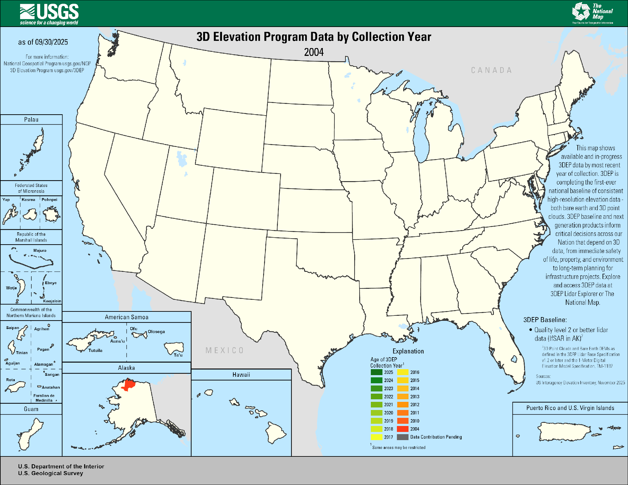
3DEP Quality Data by Collection Year Animated GIF
This animated GIF is a map of the United States and its territories shows geographic extent of planned, existing, and in-progress 3DEP data acquisition projects by year.
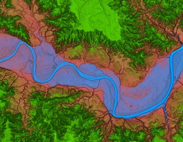
Theodore Roosevelt National Park 3DEP Lidar derived DEM Blue Green
Theodore Roosevelt National Park 3DEP Lidar derived DEM Blue GreenOverhead blue green view of Theodore Roosevelt National Park from 3DEP Lidar derived DEM USGS_OPR_McKenzie_County_2014_QL2_Lidar
Theodore Roosevelt National Park 3DEP Lidar derived DEM Blue Green
Theodore Roosevelt National Park 3DEP Lidar derived DEM Blue GreenOverhead blue green view of Theodore Roosevelt National Park from 3DEP Lidar derived DEM USGS_OPR_McKenzie_County_2014_QL2_Lidar

3DEP lidar over Millsite Reservoir, UT
3DEP lidar rendering of Millsite Reservoir near Millsite State Park, Utah.
3DEP lidar rendering of Millsite Reservoir near Millsite State Park, Utah.

3D model of Pu‘u ‘Ō‘ō's crater
This 3D model of Pu‘u ‘Ō‘ō's crater was created from thermal images during an overflight of the cone. The deepest portion of the crater is about 320 meters (1050 feet) below the crater floor that existed prior to April 30.
This 3D model of Pu‘u ‘Ō‘ō's crater was created from thermal images during an overflight of the cone. The deepest portion of the crater is about 320 meters (1050 feet) below the crater floor that existed prior to April 30.

Digital Elevation Model for Newberry Volcano and vicinity.
Digital Elevation Model for Newberry Volcano and vicinity.High-resolution digital elevation dataset for Newberry Volcano and vicinity, Oregon, based on lidar survey of August-September, 2010 and bathymetric survey of June, 2001.
Digital Elevation Model for Newberry Volcano and vicinity.
Digital Elevation Model for Newberry Volcano and vicinity.High-resolution digital elevation dataset for Newberry Volcano and vicinity, Oregon, based on lidar survey of August-September, 2010 and bathymetric survey of June, 2001.

3DEP lidar Washington Monument, D.C. oblique view
A 3D dimensional oblique visualization made by 3DEP lidar point cloud of the Washington Memorial, Washington D.C.
A 3D dimensional oblique visualization made by 3DEP lidar point cloud of the Washington Memorial, Washington D.C.

3DEP, El Paso
3D elevation data for El Paso, Texas, in the form of a lidar point cloud. These data along with other products provide valuable productivity, safety, and cost-saving benefits to instrastructure improvement projects. I(mage provided by Jason Stoker - USGS).
3D elevation data for El Paso, Texas, in the form of a lidar point cloud. These data along with other products provide valuable productivity, safety, and cost-saving benefits to instrastructure improvement projects. I(mage provided by Jason Stoker - USGS).

Elevation
The National Elevation Dataset (NED) is the primary elevation data product produced and distributed by the USGS National 3D Elevation Program (3DEP). The NED provides seamless raster elevation data of the conterminous United States, Alaska, Hawaii, and the island territories.
The National Elevation Dataset (NED) is the primary elevation data product produced and distributed by the USGS National 3D Elevation Program (3DEP). The NED provides seamless raster elevation data of the conterminous United States, Alaska, Hawaii, and the island territories.

PubTalk 11/2010 — Silicon, Software, and Science
Monitoring the Earth's Landscape with Low-Cost High-Tech
by Rian Bogle, Remote Sensing Specialist
Monitoring the Earth's Landscape with Low-Cost High-Tech
by Rian Bogle, Remote Sensing Specialist
Related
What is a digital elevation model (DEM)? What is a digital elevation model (DEM)?
A Digital Elevation Model (DEM) is a representation of the bare ground (bare earth) topographic surface of the Earth excluding trees, buildings, and any other surface objects. DEMs are created from a variety of sources. USGS DEMs used to be derived primarily from topographic maps. Those are being systematically replaced with DEMs derived from high-resolution lidar and IfSAR (Alaska only) data...
What types of elevation datasets are available, what formats do they come in, and where can I download them? What types of elevation datasets are available, what formats do they come in, and where can I download them?
Digital elevation data for the United States and its territories are available through The National Map Downloader. Click the “Help” link at the top of the page for detailed instructions on how to find and download data. There's a separate site for The National Map Services. Downloads and map services are free; no account is required. The 3D Elevation Program (3DEP) products and services available...
What is the difference between lidar data and a digital elevation model (DEM)? What is the difference between lidar data and a digital elevation model (DEM)?
Light detection and ranging (lidar) data are collected from aircraft using sensors that detect the reflections of a pulsed laser beam. The reflections are recorded as millions of individual points, collectively called a “point cloud,” that represent the 3D positions of objects on the surface including buildings, vegetation, and the ground. Digital elevation models ( DEMs) are one of many products...
How do I download The National Map data products? How do I download The National Map data products?
Download or access The National Map data products via several applications and websites: The National Map Download Client – The primary site for data downloads. See the training videos (lessons 4a-4d) or click the Help link at the top of the Downloader for detailed instructions. LidarExplorer – Lidar Point Cloud data only. See where lidar is available, get a list of downloadable products, and...
3DEP Quality Data by Collection Year Animated GIF
This animated GIF is a map of the United States and its territories shows geographic extent of planned, existing, and in-progress 3DEP data acquisition projects by year.
This animated GIF is a map of the United States and its territories shows geographic extent of planned, existing, and in-progress 3DEP data acquisition projects by year.
Theodore Roosevelt National Park 3DEP Lidar derived DEM Blue Green
Theodore Roosevelt National Park 3DEP Lidar derived DEM Blue GreenOverhead blue green view of Theodore Roosevelt National Park from 3DEP Lidar derived DEM USGS_OPR_McKenzie_County_2014_QL2_Lidar
Theodore Roosevelt National Park 3DEP Lidar derived DEM Blue Green
Theodore Roosevelt National Park 3DEP Lidar derived DEM Blue GreenOverhead blue green view of Theodore Roosevelt National Park from 3DEP Lidar derived DEM USGS_OPR_McKenzie_County_2014_QL2_Lidar
3DEP lidar over Millsite Reservoir, UT
3DEP lidar rendering of Millsite Reservoir near Millsite State Park, Utah.
3DEP lidar rendering of Millsite Reservoir near Millsite State Park, Utah.
3D model of Pu‘u ‘Ō‘ō's crater
This 3D model of Pu‘u ‘Ō‘ō's crater was created from thermal images during an overflight of the cone. The deepest portion of the crater is about 320 meters (1050 feet) below the crater floor that existed prior to April 30.
This 3D model of Pu‘u ‘Ō‘ō's crater was created from thermal images during an overflight of the cone. The deepest portion of the crater is about 320 meters (1050 feet) below the crater floor that existed prior to April 30.
Digital Elevation Model for Newberry Volcano and vicinity.
Digital Elevation Model for Newberry Volcano and vicinity.High-resolution digital elevation dataset for Newberry Volcano and vicinity, Oregon, based on lidar survey of August-September, 2010 and bathymetric survey of June, 2001.
Digital Elevation Model for Newberry Volcano and vicinity.
Digital Elevation Model for Newberry Volcano and vicinity.High-resolution digital elevation dataset for Newberry Volcano and vicinity, Oregon, based on lidar survey of August-September, 2010 and bathymetric survey of June, 2001.
3DEP lidar Washington Monument, D.C. oblique view
A 3D dimensional oblique visualization made by 3DEP lidar point cloud of the Washington Memorial, Washington D.C.
A 3D dimensional oblique visualization made by 3DEP lidar point cloud of the Washington Memorial, Washington D.C.
3DEP, El Paso
3D elevation data for El Paso, Texas, in the form of a lidar point cloud. These data along with other products provide valuable productivity, safety, and cost-saving benefits to instrastructure improvement projects. I(mage provided by Jason Stoker - USGS).
3D elevation data for El Paso, Texas, in the form of a lidar point cloud. These data along with other products provide valuable productivity, safety, and cost-saving benefits to instrastructure improvement projects. I(mage provided by Jason Stoker - USGS).
Elevation
The National Elevation Dataset (NED) is the primary elevation data product produced and distributed by the USGS National 3D Elevation Program (3DEP). The NED provides seamless raster elevation data of the conterminous United States, Alaska, Hawaii, and the island territories.
The National Elevation Dataset (NED) is the primary elevation data product produced and distributed by the USGS National 3D Elevation Program (3DEP). The NED provides seamless raster elevation data of the conterminous United States, Alaska, Hawaii, and the island territories.
PubTalk 11/2010 — Silicon, Software, and Science
Monitoring the Earth's Landscape with Low-Cost High-Tech
by Rian Bogle, Remote Sensing Specialist
Monitoring the Earth's Landscape with Low-Cost High-Tech
by Rian Bogle, Remote Sensing Specialist
Updated Date: June 23, 2026