
This animated GIF is a map of the United States and its territories shows geographic extent of planned, existing, and in-progress 3DEP data acquisition projects by year.
What is the coverage of 3D Elevation Program (3DEP) DEMs?
Elevation products are summarized on our 3-D Elevation (3DEP) Products and Services website. View detailed availability maps (status graphics) through several sites:
- The National Map Download Client – Click “Show” below each elevation product
- Lidar Availability Viewer - Lidar point cloud only
- LidarExplorer – Lidar point cloud only
- DEM Availability Viewer - 1 meter DEMs only
Learn more: What is 3DEP?
Related

How do I report errors in 3D Elevation Program (3DEP) elevation data? How do I report errors in 3D Elevation Program (3DEP) elevation data?
If you think you’ve found an error in USGS elevation data, please send an email to tnm_help@usgs.gov. We will add the reported information to our "Digital Elevation Model Issues" data log for further analysis and possible correction. Spikes, pits, seam-line anomalies, and other data errors are of concern to us. We are working to correct or minimize known issues, but it will take some time. Errors...

What is the difference between lidar data and a digital elevation model (DEM)? What is the difference between lidar data and a digital elevation model (DEM)?
Light detection and ranging (lidar) data are collected from aircraft using sensors that detect the reflections of a pulsed laser beam. The reflections are recorded as millions of individual points, collectively called a “point cloud,” that represent the 3D positions of objects on the surface including buildings, vegetation, and the ground. Digital elevation models ( DEMs) are one of many products...

Where can I find 3D Elevation Program (3DEP) product updates and status maps? Where can I find 3D Elevation Program (3DEP) product updates and status maps?
3D Elevation Program (3DEP) product updates and status maps are available at these sites: Updates The National Map Data Delivery News Subscribe to Simple Notification Services to receive emails regarding changes to the status of The National Map Services Status Maps The National Map Download Client – Click “Show” below each elevation product LidarExplorer – Lidar point cloud only DEM Availability...

What is Lidar data and where can I download it? What is Lidar data and where can I download it?
Light Detection and Ranging ( lidar) is a technology used to create high-resolution models of ground elevation with a vertical accuracy of 10 centimeters (4 inches). Lidar equipment, which includes a laser scanner, a Global Positioning System (GPS), and an Inertial Navigation System (INS), is typically mounted on a small aircraft. The laser scanner transmits brief pulses of light to the ground...
3DEP Quality Data by Collection Year Animated GIF
This animated GIF is a map of the United States and its territories shows geographic extent of planned, existing, and in-progress 3DEP data acquisition projects by year.
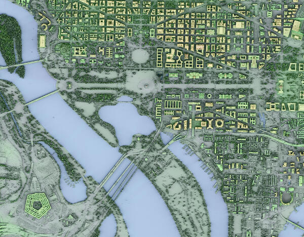
Washington, DC 3DEP Lidar derived DSM Time in Daylight
Washington, DC 3DEP Lidar derived DSM Time in DaylightAn image utilizing 3DEP-derived Digital Surface Model (DSM) and Time in Daylight calculation for Washington, DC.
Project: USGS_LPC_Sandy_Supplemental_NCR_VA_MD_DC_QL2_LiDAR
Washington, DC 3DEP Lidar derived DSM Time in Daylight
Washington, DC 3DEP Lidar derived DSM Time in DaylightAn image utilizing 3DEP-derived Digital Surface Model (DSM) and Time in Daylight calculation for Washington, DC.
Project: USGS_LPC_Sandy_Supplemental_NCR_VA_MD_DC_QL2_LiDAR

Theodore Roosevelt National Park 3DEP Lidar derived DEM 3D Blue Green
Theodore Roosevelt National Park 3DEP Lidar derived DEM 3D Blue Green3D view of Theodore Roosevelt National Park from 3DEP Lidar derived DEM USGS_OPR_McKenzie_County_2014_QL2_Lidar
Theodore Roosevelt National Park 3DEP Lidar derived DEM 3D Blue Green
Theodore Roosevelt National Park 3DEP Lidar derived DEM 3D Blue Green3D view of Theodore Roosevelt National Park from 3DEP Lidar derived DEM USGS_OPR_McKenzie_County_2014_QL2_Lidar

Majuro Atoll — Topobathymetric Model
This video is of is a three-dimensional (3D) view of the Majuro Atoll, Republic of the Marshall Islands topobathymetric model which consists of topography (land elevation) and bathymetry (water depth). This video shows the importance of high-resolution, detailed topobathymetric models because the highest natural elevation for the Majuro Atoll is only three meters.
This video is of is a three-dimensional (3D) view of the Majuro Atoll, Republic of the Marshall Islands topobathymetric model which consists of topography (land elevation) and bathymetry (water depth). This video shows the importance of high-resolution, detailed topobathymetric models because the highest natural elevation for the Majuro Atoll is only three meters.

3DEP lidar Washington Monument, D.C. oblique view
A 3D dimensional oblique visualization made by 3DEP lidar point cloud of the Washington Memorial, Washington D.C.
A 3D dimensional oblique visualization made by 3DEP lidar point cloud of the Washington Memorial, Washington D.C.

3DEP, El Paso
3D elevation data for El Paso, Texas, in the form of a lidar point cloud. These data along with other products provide valuable productivity, safety, and cost-saving benefits to instrastructure improvement projects. I(mage provided by Jason Stoker - USGS).
3D elevation data for El Paso, Texas, in the form of a lidar point cloud. These data along with other products provide valuable productivity, safety, and cost-saving benefits to instrastructure improvement projects. I(mage provided by Jason Stoker - USGS).

Elevation
The National Elevation Dataset (NED) is the primary elevation data product produced and distributed by the USGS National 3D Elevation Program (3DEP). The NED provides seamless raster elevation data of the conterminous United States, Alaska, Hawaii, and the island territories.
The National Elevation Dataset (NED) is the primary elevation data product produced and distributed by the USGS National 3D Elevation Program (3DEP). The NED provides seamless raster elevation data of the conterminous United States, Alaska, Hawaii, and the island territories.

PubTalk 11/2010 — Silicon, Software, and Science
Monitoring the Earth's Landscape with Low-Cost High-Tech
by Rian Bogle, Remote Sensing Specialist
Monitoring the Earth's Landscape with Low-Cost High-Tech
by Rian Bogle, Remote Sensing Specialist
Related
How do I report errors in 3D Elevation Program (3DEP) elevation data? How do I report errors in 3D Elevation Program (3DEP) elevation data?
If you think you’ve found an error in USGS elevation data, please send an email to tnm_help@usgs.gov. We will add the reported information to our "Digital Elevation Model Issues" data log for further analysis and possible correction. Spikes, pits, seam-line anomalies, and other data errors are of concern to us. We are working to correct or minimize known issues, but it will take some time. Errors...
What is the difference between lidar data and a digital elevation model (DEM)? What is the difference between lidar data and a digital elevation model (DEM)?
Light detection and ranging (lidar) data are collected from aircraft using sensors that detect the reflections of a pulsed laser beam. The reflections are recorded as millions of individual points, collectively called a “point cloud,” that represent the 3D positions of objects on the surface including buildings, vegetation, and the ground. Digital elevation models ( DEMs) are one of many products...
Where can I find 3D Elevation Program (3DEP) product updates and status maps? Where can I find 3D Elevation Program (3DEP) product updates and status maps?
3D Elevation Program (3DEP) product updates and status maps are available at these sites: Updates The National Map Data Delivery News Subscribe to Simple Notification Services to receive emails regarding changes to the status of The National Map Services Status Maps The National Map Download Client – Click “Show” below each elevation product LidarExplorer – Lidar point cloud only DEM Availability...
What is Lidar data and where can I download it? What is Lidar data and where can I download it?
Light Detection and Ranging ( lidar) is a technology used to create high-resolution models of ground elevation with a vertical accuracy of 10 centimeters (4 inches). Lidar equipment, which includes a laser scanner, a Global Positioning System (GPS), and an Inertial Navigation System (INS), is typically mounted on a small aircraft. The laser scanner transmits brief pulses of light to the ground...
3DEP Quality Data by Collection Year Animated GIF
This animated GIF is a map of the United States and its territories shows geographic extent of planned, existing, and in-progress 3DEP data acquisition projects by year.
This animated GIF is a map of the United States and its territories shows geographic extent of planned, existing, and in-progress 3DEP data acquisition projects by year.
Washington, DC 3DEP Lidar derived DSM Time in Daylight
Washington, DC 3DEP Lidar derived DSM Time in DaylightAn image utilizing 3DEP-derived Digital Surface Model (DSM) and Time in Daylight calculation for Washington, DC.
Project: USGS_LPC_Sandy_Supplemental_NCR_VA_MD_DC_QL2_LiDAR
Washington, DC 3DEP Lidar derived DSM Time in Daylight
Washington, DC 3DEP Lidar derived DSM Time in DaylightAn image utilizing 3DEP-derived Digital Surface Model (DSM) and Time in Daylight calculation for Washington, DC.
Project: USGS_LPC_Sandy_Supplemental_NCR_VA_MD_DC_QL2_LiDAR
Theodore Roosevelt National Park 3DEP Lidar derived DEM 3D Blue Green
Theodore Roosevelt National Park 3DEP Lidar derived DEM 3D Blue Green3D view of Theodore Roosevelt National Park from 3DEP Lidar derived DEM USGS_OPR_McKenzie_County_2014_QL2_Lidar
Theodore Roosevelt National Park 3DEP Lidar derived DEM 3D Blue Green
Theodore Roosevelt National Park 3DEP Lidar derived DEM 3D Blue Green3D view of Theodore Roosevelt National Park from 3DEP Lidar derived DEM USGS_OPR_McKenzie_County_2014_QL2_Lidar
Majuro Atoll — Topobathymetric Model
This video is of is a three-dimensional (3D) view of the Majuro Atoll, Republic of the Marshall Islands topobathymetric model which consists of topography (land elevation) and bathymetry (water depth). This video shows the importance of high-resolution, detailed topobathymetric models because the highest natural elevation for the Majuro Atoll is only three meters.
This video is of is a three-dimensional (3D) view of the Majuro Atoll, Republic of the Marshall Islands topobathymetric model which consists of topography (land elevation) and bathymetry (water depth). This video shows the importance of high-resolution, detailed topobathymetric models because the highest natural elevation for the Majuro Atoll is only three meters.
3DEP lidar Washington Monument, D.C. oblique view
A 3D dimensional oblique visualization made by 3DEP lidar point cloud of the Washington Memorial, Washington D.C.
A 3D dimensional oblique visualization made by 3DEP lidar point cloud of the Washington Memorial, Washington D.C.
3DEP, El Paso
3D elevation data for El Paso, Texas, in the form of a lidar point cloud. These data along with other products provide valuable productivity, safety, and cost-saving benefits to instrastructure improvement projects. I(mage provided by Jason Stoker - USGS).
3D elevation data for El Paso, Texas, in the form of a lidar point cloud. These data along with other products provide valuable productivity, safety, and cost-saving benefits to instrastructure improvement projects. I(mage provided by Jason Stoker - USGS).
Elevation
The National Elevation Dataset (NED) is the primary elevation data product produced and distributed by the USGS National 3D Elevation Program (3DEP). The NED provides seamless raster elevation data of the conterminous United States, Alaska, Hawaii, and the island territories.
The National Elevation Dataset (NED) is the primary elevation data product produced and distributed by the USGS National 3D Elevation Program (3DEP). The NED provides seamless raster elevation data of the conterminous United States, Alaska, Hawaii, and the island territories.
PubTalk 11/2010 — Silicon, Software, and Science
Monitoring the Earth's Landscape with Low-Cost High-Tech
by Rian Bogle, Remote Sensing Specialist
Monitoring the Earth's Landscape with Low-Cost High-Tech
by Rian Bogle, Remote Sensing Specialist
Updated Date: July 2, 2026