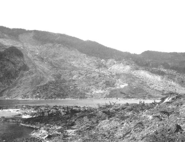
Landslides are a serious geologic hazard common to almost every State in the United States. As people move into new areas of hilly or mountainous terrain, it is important to understand the nature of their potential exposure to landslide hazards, and how cities, towns, and counties can plan for land-use, engineering of new construction and infrastructure which will reduce the costs of living with landslides.
Although the physical causes of many landslides cannot be removed, geologic investigations, good engineering practices, and effective enforcement of land-use management regulations can reduce landslide hazards. It is also important to understand the science of landslides – their causes, movement characteristics, soil properties, the geology associated with them, and where they are likely to occur.
The USGS Landslide Hazards Program helps address these needs for improved understanding by conducting research on several fundamental aspects of landslides. Thus, USGS landslide research seeks answers to such questions as these:
- Where and when will landslides occur?
- How big will they be?
- How fast and how far will landslides move?
Learn more:
Related Content
What is a landslide and what causes one?
A landslide is defined as the movement of a mass of rock, debris, or earth down a slope. Landslides are a type of "mass wasting," which denotes any down-slope movement of soil and rock under the direct influence of gravity. The term "landslide" encompasses five modes of slope movement: falls, topples, slides, spreads, and flows. These are further subdivided by the type of geologic material...
Do human activities cause landslides?
Yes, in some cases human activities can be a contributing factor in causing landslides. Many human-caused landslides can be avoided or mitigated. They are commonly a result of building roads and structures without adequate grading of slopes, poorly planned alteration of drainage patterns, and disturbing old landslides. Detailed on-site investigation is required to determine the importance of human...
How many deaths result from landslides each year?
An average of 25-50 people are killed by landslides each year in the United States. The worldwide death toll per year due to landslides is in the thousands. Most landslide fatalities are from rock falls, debris flows, or volcanic debris flows (called lahars). Twenty-three people were killed, at least 167 injured, and more than 400 homes were damaged by a series of debris flows that impacted the...
What is the difference between a landslide advisory, a landslide watch, and a landslide warning?
An advisory is a general statement about the potential of landslide activity in a given region relative to developing rainfall predictions. An advisory may include general statements about rainfall conditions that can lead to debris-flow activity, and list precautions to be taken in the event of heavy rainfall. A watch means that landslide-activity will be possible, but is not imminent. People in...
What was the largest landslide in the United States? In the world?
The largest subaerial (on land) landslide in Earth's recorded history was connected with the 1980 eruption of Mount St. Helens volcano in Washington state, USA. That landslide had a volume of 2.8 cubic kilometers (0.67 cubic miles) of material and the landslide traveled about 22.5 kilometers (14 miles) down the North Fork Toutle River. Average landside depth was 46 meters (150 feet) with a maximum...
Can major landslides and debris flows happen in all areas of the U.S.?
Landslides can and do occur in every state and territory of the U.S.; however, the type, severity, and frequency of landslide activity varies from place to place, depending on the terrain, geology, and climate. Major storms have caused major or widespread landslides in Washington state, Oregon, California, Colorado, Idaho, Hawaii, Virginia, Ohio, Pennsylvania, Tennessee, North Carolina, Puerto...
Under what circumstances do U.S. Geological Survey landslide personnel conduct field work in landslide-prone areas?
USGS landslide researchers have ongoing field projects in several areas of the United States, including parts of the Pacific coastal ranges, Rocky Mountains, and the Appalachians. USGS scientists also respond to major landslide events, including some that result in federally-declared disasters. In some cases, USGS scientists respond to landslides in foreign countries that request assistance...
How do landslides cause tsunamis?
Tsunamis are large, potentially deadly and destructive sea waves, most of which are formed as a result of submarine earthquakes. They can also result from the eruption or collapse of island or coastal volcanoes and from giant landslides on marine margins. These landslides, in turn, are often triggered by earthquakes. Tsunamis can be generated on impact as a rapidly moving landslide mass enters the...
What should I know about wildfires and debris flows?
Wildland fires are inevitable in the western United States. Expansion of human development into forested areas has created a situation where wildfires can adversely affect lives and property, as can the flooding and landslides that occur in the aftermath of the fires. There is a need to develop tools and methods to identify and quantify the potential hazards posed by landslides produced from...
National strategy for landslide loss reduction
New model of the Barry Arm landslide in Alaska reveals potential tsunami wave heights of 2 meters, values much lower than previously estimated
Science for a risky world—A U.S. Geological Survey plan for risk research and applications
Lahar—River of volcanic mud and debris
THRESH—Software for tracking rainfall thresholds for landslide and debris-flow occurrence, user manual
The 3D Elevation Program—Landslide recognition, hazard assessment, and mitigation support
Real-time monitoring of landslides
The Landslide Handbook - A Guide to Understanding Landslides
Video documentation of experiments at the USGS debris-flow flume 1992–2017
Southern California landslides-an overview
Landslide hazards: A national threat
Related Content
- FAQ
What is a landslide and what causes one?
A landslide is defined as the movement of a mass of rock, debris, or earth down a slope. Landslides are a type of "mass wasting," which denotes any down-slope movement of soil and rock under the direct influence of gravity. The term "landslide" encompasses five modes of slope movement: falls, topples, slides, spreads, and flows. These are further subdivided by the type of geologic material...
Do human activities cause landslides?
Yes, in some cases human activities can be a contributing factor in causing landslides. Many human-caused landslides can be avoided or mitigated. They are commonly a result of building roads and structures without adequate grading of slopes, poorly planned alteration of drainage patterns, and disturbing old landslides. Detailed on-site investigation is required to determine the importance of human...
How many deaths result from landslides each year?
An average of 25-50 people are killed by landslides each year in the United States. The worldwide death toll per year due to landslides is in the thousands. Most landslide fatalities are from rock falls, debris flows, or volcanic debris flows (called lahars). Twenty-three people were killed, at least 167 injured, and more than 400 homes were damaged by a series of debris flows that impacted the...
What is the difference between a landslide advisory, a landslide watch, and a landslide warning?
An advisory is a general statement about the potential of landslide activity in a given region relative to developing rainfall predictions. An advisory may include general statements about rainfall conditions that can lead to debris-flow activity, and list precautions to be taken in the event of heavy rainfall. A watch means that landslide-activity will be possible, but is not imminent. People in...
What was the largest landslide in the United States? In the world?
The largest subaerial (on land) landslide in Earth's recorded history was connected with the 1980 eruption of Mount St. Helens volcano in Washington state, USA. That landslide had a volume of 2.8 cubic kilometers (0.67 cubic miles) of material and the landslide traveled about 22.5 kilometers (14 miles) down the North Fork Toutle River. Average landside depth was 46 meters (150 feet) with a maximum...
Can major landslides and debris flows happen in all areas of the U.S.?
Landslides can and do occur in every state and territory of the U.S.; however, the type, severity, and frequency of landslide activity varies from place to place, depending on the terrain, geology, and climate. Major storms have caused major or widespread landslides in Washington state, Oregon, California, Colorado, Idaho, Hawaii, Virginia, Ohio, Pennsylvania, Tennessee, North Carolina, Puerto...
Under what circumstances do U.S. Geological Survey landslide personnel conduct field work in landslide-prone areas?
USGS landslide researchers have ongoing field projects in several areas of the United States, including parts of the Pacific coastal ranges, Rocky Mountains, and the Appalachians. USGS scientists also respond to major landslide events, including some that result in federally-declared disasters. In some cases, USGS scientists respond to landslides in foreign countries that request assistance...
How do landslides cause tsunamis?
Tsunamis are large, potentially deadly and destructive sea waves, most of which are formed as a result of submarine earthquakes. They can also result from the eruption or collapse of island or coastal volcanoes and from giant landslides on marine margins. These landslides, in turn, are often triggered by earthquakes. Tsunamis can be generated on impact as a rapidly moving landslide mass enters the...
What should I know about wildfires and debris flows?
Wildland fires are inevitable in the western United States. Expansion of human development into forested areas has created a situation where wildfires can adversely affect lives and property, as can the flooding and landslides that occur in the aftermath of the fires. There is a need to develop tools and methods to identify and quantify the potential hazards posed by landslides produced from...
- Multimedia
- Publications
Filter Total Items: 15
National strategy for landslide loss reduction
Executive SummaryLandslide hazards are present in all 50 States and most U.S. territories, and they affect lives, property, infrastructure, and the environment. Landslides are the downslope movement of earth materials under the force of gravity. They can occur without any obvious trigger. Widespread or severe landslide events are often driven by such hazards as hurricanes, earthquakes, volcanicAuthorsJonathan W. Godt, Nathan J. Wood, Alice Pennaz, Connor M. Dacey, Benjamin B. Mirus, Lauren N. Schaefer, Stephen L. SlaughterNew model of the Barry Arm landslide in Alaska reveals potential tsunami wave heights of 2 meters, values much lower than previously estimated
The retreat of Barry Glacier has contributed to the destabilization of slopes in Barry Arm, creating the possibility that a landslide could rapidly enter the fjord and trigger a tsunami.The U.S. Geological Survey (USGS) recently released a report documenting potential tsunami wave heights in the event of a large, fast-moving landslide at the Barry Arm fiord near Prince William Sound, Alaska (BarnhAuthorsMarísa A. Macías, Katherine R. Barnhart, Dennis M. StaleyScience for a risky world—A U.S. Geological Survey plan for risk research and applications
Executive SummaryNatural hazards—including earthquakes, tsunamis, volcanic eruptions, landslides, hurricanes, droughts, floods, wildfires, geomagnetic storms, and pandemics—can wreak havoc on human communities, the economy, and natural resources for years following an initial event. Hazards can claim lives and cause billions of dollars in damage to homes and infrastructure as well as lost or comprAuthorsK. A. Ludwig, David W. Ramsey, Nathan J. Wood, A.B. Pennaz, Jonathan W. Godt, Nathaniel G. Plant, Nicolas Luco, Todd A. Koenig, Kenneth W. Hudnut, Donyelle K. Davis, Patricia R. BrightLahar—River of volcanic mud and debris
Lahar, an Indonesian word for volcanic mudflow, is a mixture of water, mud, and volcanic rock flowing swiftly along a channel draining a volcano. Lahars can form during or after eruptions, or even during periods of inactivity. They are among the greatest threats volcanoes pose to people and property. Lahars can occur with little to no warning, and may travel great distances at high speeds, destroyAuthorsJon J. Major, Thomas C. Pierson, James W. VallanceTHRESH—Software for tracking rainfall thresholds for landslide and debris-flow occurrence, user manual
Precipitation thresholds are used in many areas to provide early warning of precipitation-induced landslides and debris flows, and the software distribution THRESH is designed for automated tracking of precipitation, including precipitation forecasts, relative to thresholds for landslide occurrence. This software is also useful for analyzing multiyear precipitation records to compare timing of thrAuthorsRex L. Baum, Sarah J. Fischer, Jacob C. VigilThe 3D Elevation Program—Landslide recognition, hazard assessment, and mitigation support
The U.S. Geological Survey (USGS) Landslide Hazards Program conducts landslide hazard assessments, pursues landslide investigations and forecasts, provides technical assistance to respond to landslide emergencies, and engages in outreach. All of these activities benefit from the availability of high-resolution, three-dimensional (3D) elevation information in the form of light detection and rangingAuthorsVicki Lukas, William J. Carswell, Jr.Real-time monitoring of landslides
Landslides cause fatalities and property damage throughout the Nation. To reduce the impact from hazardous landslides, the U.S. Geological Survey develops and uses real-time and near-real-time landslide monitoring systems. Monitoring can detect when hillslopes are primed for sliding and can provide early indications of rapid, catastrophic movement. Continuous information from up-to-the-minute or rAuthorsMark E. Reid, Richard G. LaHusen, Rex L. Baum, Jason W. Kean, William H. Schulz, Lynn M. HighlandThe Landslide Handbook - A Guide to Understanding Landslides
This handbook is intended to be a resource for people affected by landslides to acquire further knowledge, especially about the conditions that are unique to their neighborhoods and communities. Considerable literature and research are available concerning landslides, but unfortunately little of it is synthesized and integrated to address the geographically unique geologic and climatic conditionsAuthorsLynn M. Highland, Peter BobrowskyVideo documentation of experiments at the USGS debris-flow flume 1992–2017
This set of videos presents about 18 hours of footage documenting the 163 experiments conducted at the USGS debris-flow flume from 1992 to 2017. Owing to improvements in video technology over the years, the quality of footage from recent experiments generally exceeds that from earlier experiments.Use the list below to access the individual videos, which are mostly grouped by date and subject matteAuthorsMatthew Logan, Richard M. IversonSouthern California landslides-an overview
Southern California lies astride a major tectonic plate boundary defined by the San Andreas Fault and numerous related faults that are spread across a broad region. This dynamic tectonic environment has created a spectacular landscape of rugged mountains and steep-walled valleys that compose much of the region’s scenic beauty. Unfortunately, this extraordinary landscape also presents serious geoloAuthorsLandslide hazards: A national threat
Landslides occur and can cause damage in all 50 States. Severe storms, earthquakes, volcanic activity, coastal wave attack, and wildfires can cause widespread slope instability. Landslide danger may be high even as emergency personnel are providing rescue and recovery services. To address landslide hazards, several questions must be considered: Where and when will landslides occur? How big willAuthors - News