
Photograph of the Gros Ventre Slide 100 years after it occurred. View is to the south, with the landslide scar visible in the middle of the treed hillslope across the valley. Lower Slide Lake, which formed behind the landslide debris, is visible on the left side of the photograph. Photo by James Mauch, Wyoming State Geological Survey, June 7, 2025.
Can major landslides and debris flows happen in all areas of the U.S.?
Landslides can and do occur in every state and territory of the U.S.; however, the type, severity, and frequency of landslide activity varies from place to place, depending on the terrain, geology, and climate.
Major storms have caused major or widespread landslides in Washington state, Oregon, California, Colorado, Idaho, Hawaii, Virginia, Ohio, Pennsylvania, Tennessee, North Carolina, Puerto Rico, and elsewhere. Rapid snowmelt has caused landslides in Colorado, Nevada, Utah, Wyoming, and Washington State, as well as other mountainous states. The Appalachian Mountains, the Rocky Mountains, the Pacific Coastal Ranges, and some parts of Alaska and Hawaii have moderate to severe landslide problems. Any area of weak or fractured materials resting on a steep slope can and will likely experience landslides.
Although the physical causes of many landslides cannot be removed, geologic investigations, good engineering practices, and effective enforcement of land-use management regulations can reduce landslide hazards.
Learn more:
Related

What is a landslide and what causes one? What is a landslide and what causes one?
A landslide is defined as the movement of a mass of rock, debris, or earth down a slope. Landslides are a type of "mass wasting," which denotes any down-slope movement of soil and rock under the direct influence of gravity. The term "landslide" encompasses five modes of slope movement: falls, topples, slides, spreads, and flows. These are further subdivided by the type of geologic material...

Do human activities cause landslides? Do human activities cause landslides?
Yes, in some cases human activities can be a contributing factor in causing landslides. Many human-caused landslides can be avoided or mitigated. They are commonly a result of building roads and structures without adequate grading of slopes, poorly planned alteration of drainage patterns, and disturbing old landslides. Detailed on-site investigation is required to determine the importance of human...

How many deaths result from landslides each year? How many deaths result from landslides each year?
An average of 25-50 people are killed by landslides each year in the United States. The worldwide death toll per year due to landslides is in the thousands. Most landslide fatalities are from rock falls, debris flows, or volcanic debris flows (called lahars). Twenty-three people were killed, at least 167 injured, and more than 400 homes were damaged by a series of debris flows that impacted the...

Under what circumstances do U.S. Geological Survey landslide personnel conduct field work in landslide-prone areas? Under what circumstances do U.S. Geological Survey landslide personnel conduct field work in landslide-prone areas?
USGS landslide researchers have ongoing field projects in several areas of the United States, including parts of the Pacific coastal ranges, Rocky Mountains, and the Appalachians. USGS scientists also respond to major landslide events, including some that result in federally-declared disasters. In some cases, USGS scientists respond to landslides in foreign countries that request assistance...

How do landslides cause tsunamis? How do landslides cause tsunamis?
Tsunamis are large, potentially deadly and destructive sea waves, most of which are formed as a result of submarine earthquakes. They can also result from the eruption or collapse of island or coastal volcanoes and from giant landslides on marine margins. These landslides, in turn, are often triggered by earthquakes. Tsunamis can be generated on impact as a rapidly moving landslide mass enters the...

What should I know about wildfires and debris flows? What should I know about wildfires and debris flows?
Wildland fires are inevitable in the western United States. Expansion of human development into forested areas has created a situation where wildfires can adversely affect lives and property, as can the flooding and landslides that occur in the aftermath of the fires. There is a need to develop tools and methods to identify and quantify the potential hazards posed by landslides produced from...

Why study landslides? Why study landslides?
Landslides are a serious geologic hazard common to almost every State in the United States. As people move into new areas of hilly or mountainous terrain, it is important to understand the nature of their potential exposure to landslide hazards, and how cities, towns, and counties can plan for land-use, engineering of new construction and infrastructure which will reduce the costs of living with...

Gros Ventre landslide area in 2025
Photograph of the Gros Ventre Slide 100 years after it occurred. View is to the south, with the landslide scar visible in the middle of the treed hillslope across the valley. Lower Slide Lake, which formed behind the landslide debris, is visible on the left side of the photograph. Photo by James Mauch, Wyoming State Geological Survey, June 7, 2025.

Multiple landslides and mudflows in Bat Cave, NC. - 10/13/2024
Multiple landslides and mudflows in Bat Cave, NC. - 10/13/2024Coordinates of photographer: Latitude: 35° 27’ 42.48” N Longitude: 82° 16’ 57.75” W
Date: 10/13/24
Caption: Multiple landslides and mudflows in Bat Cave, NC
Taken during Hurricane Helene LASER response

Where Do Landslides Occur?
A map of the United States including Hawaii, Alaska, and Puerto Rico shows landslide susceptibility from yellow (low) to red (high), where the areas without shading represent negligible potential for landslides.
A map of the United States including Hawaii, Alaska, and Puerto Rico shows landslide susceptibility from yellow (low) to red (high), where the areas without shading represent negligible potential for landslides.

Big Sur Landslide, July 7, 2017
USGS scientists continue to monitor the slide by collecting imagery every couple of weeks, weather permitting. Pilot Bob Van Wagenen, contracted through the Department of the Interior’s Office of Aviation Services, takes air photos for Jon Warrick’s Big Sur Landslide team, flying out of the Watsonville Municipal Airport in a Cessna 182R.
USGS scientists continue to monitor the slide by collecting imagery every couple of weeks, weather permitting. Pilot Bob Van Wagenen, contracted through the Department of the Interior’s Office of Aviation Services, takes air photos for Jon Warrick’s Big Sur Landslide team, flying out of the Watsonville Municipal Airport in a Cessna 182R.

PubTalk 10/2016 — Rockfalls in California's Sierra Nevada
PubTalk 10/2016 — Rockfalls in California's Sierra NevadaRock falls in California’s Sierra Nevada - Pursuing explanations for exfoliation and seemingly spontaneous fracture of rock
PubTalk 10/2016 — Rockfalls in California's Sierra Nevada
PubTalk 10/2016 — Rockfalls in California's Sierra NevadaRock falls in California’s Sierra Nevada - Pursuing explanations for exfoliation and seemingly spontaneous fracture of rock

Landslide Spreads 6 Miles Across Glacier Bay National Park
Landslide Spreads 6 Miles Across Glacier Bay National ParkOn June 28, 2016, a 4,000-foot-high mountainside in Glacier Bay National Park and Preserve collapsed, sending rocky debris equivalent to 60 million mid-size SUVs tumbling onto nearby Lamplugh Glacier.

Volcano Web Shorts 2: Debris Flows
Debris flows are hazardous flows of rock, sediment and water that surge down mountain slopes and into adjacent valleys. Hydrologist Richard Iverson describes the nature of debris-flow research and explains how debris flow experiments are conducted at the USGS Debris Flow Flume, west of Eugene, Oregon.
Debris flows are hazardous flows of rock, sediment and water that surge down mountain slopes and into adjacent valleys. Hydrologist Richard Iverson describes the nature of debris-flow research and explains how debris flow experiments are conducted at the USGS Debris Flow Flume, west of Eugene, Oregon.

2007 Landslide in La Jolla, California
This event occurred on October 4, 2007 in La Jolla, California. A landslide, perhaps first indicated in July by cracks appearing in pavement and homes along Soledad Mountain Road, struck suddenly when a massive slab of hillside broke loose, sending tons of dirt cascading toward streets below.
This event occurred on October 4, 2007 in La Jolla, California. A landslide, perhaps first indicated in July by cracks appearing in pavement and homes along Soledad Mountain Road, struck suddenly when a massive slab of hillside broke loose, sending tons of dirt cascading toward streets below.

2005 Landslide in La Conchita, CA
On January 10, 2005, a landslide struck the community of La Conchita in Ventura County, California, destroying or seriously damaging 36 houses and killing 10 people. For a USGS rerpot on this event, please see USGS Open-file report, "Landslide Hazards at La Conchita, California."
On January 10, 2005, a landslide struck the community of La Conchita in Ventura County, California, destroying or seriously damaging 36 houses and killing 10 people. For a USGS rerpot on this event, please see USGS Open-file report, "Landslide Hazards at La Conchita, California."
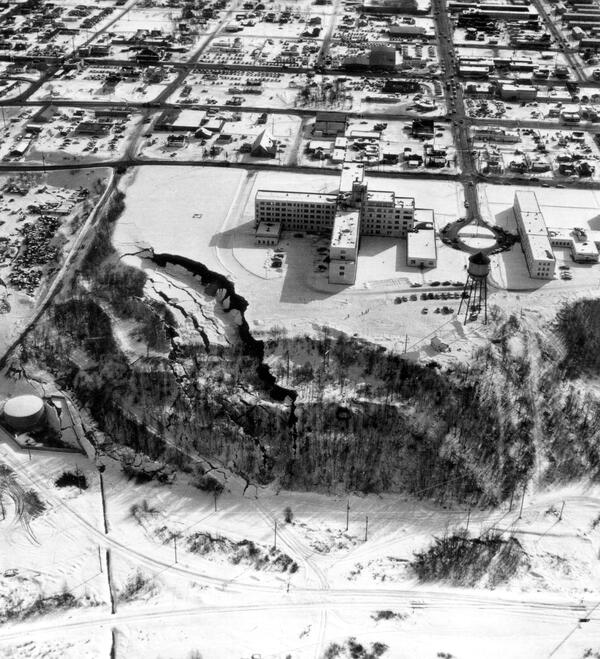
Native Hospital landslide in Anchorage District, Cook Inlet Region, Alaska
Native Hospital landslide in Anchorage District, Cook Inlet Region, AlaskaNative Hospital landslide in Anchorage, showing graben and pressure ridge. The scar of an older landslide is transected by the slide of March 27.
Native Hospital landslide in Anchorage District, Cook Inlet Region, Alaska
Native Hospital landslide in Anchorage District, Cook Inlet Region, AlaskaNative Hospital landslide in Anchorage, showing graben and pressure ridge. The scar of an older landslide is transected by the slide of March 27.
Related
What is a landslide and what causes one? What is a landslide and what causes one?
A landslide is defined as the movement of a mass of rock, debris, or earth down a slope. Landslides are a type of "mass wasting," which denotes any down-slope movement of soil and rock under the direct influence of gravity. The term "landslide" encompasses five modes of slope movement: falls, topples, slides, spreads, and flows. These are further subdivided by the type of geologic material...
Do human activities cause landslides? Do human activities cause landslides?
Yes, in some cases human activities can be a contributing factor in causing landslides. Many human-caused landslides can be avoided or mitigated. They are commonly a result of building roads and structures without adequate grading of slopes, poorly planned alteration of drainage patterns, and disturbing old landslides. Detailed on-site investigation is required to determine the importance of human...
How many deaths result from landslides each year? How many deaths result from landslides each year?
An average of 25-50 people are killed by landslides each year in the United States. The worldwide death toll per year due to landslides is in the thousands. Most landslide fatalities are from rock falls, debris flows, or volcanic debris flows (called lahars). Twenty-three people were killed, at least 167 injured, and more than 400 homes were damaged by a series of debris flows that impacted the...
Under what circumstances do U.S. Geological Survey landslide personnel conduct field work in landslide-prone areas? Under what circumstances do U.S. Geological Survey landslide personnel conduct field work in landslide-prone areas?
USGS landslide researchers have ongoing field projects in several areas of the United States, including parts of the Pacific coastal ranges, Rocky Mountains, and the Appalachians. USGS scientists also respond to major landslide events, including some that result in federally-declared disasters. In some cases, USGS scientists respond to landslides in foreign countries that request assistance...
How do landslides cause tsunamis? How do landslides cause tsunamis?
Tsunamis are large, potentially deadly and destructive sea waves, most of which are formed as a result of submarine earthquakes. They can also result from the eruption or collapse of island or coastal volcanoes and from giant landslides on marine margins. These landslides, in turn, are often triggered by earthquakes. Tsunamis can be generated on impact as a rapidly moving landslide mass enters the...
What should I know about wildfires and debris flows? What should I know about wildfires and debris flows?
Wildland fires are inevitable in the western United States. Expansion of human development into forested areas has created a situation where wildfires can adversely affect lives and property, as can the flooding and landslides that occur in the aftermath of the fires. There is a need to develop tools and methods to identify and quantify the potential hazards posed by landslides produced from...
Why study landslides? Why study landslides?
Landslides are a serious geologic hazard common to almost every State in the United States. As people move into new areas of hilly or mountainous terrain, it is important to understand the nature of their potential exposure to landslide hazards, and how cities, towns, and counties can plan for land-use, engineering of new construction and infrastructure which will reduce the costs of living with...
Gros Ventre landslide area in 2025
Photograph of the Gros Ventre Slide 100 years after it occurred. View is to the south, with the landslide scar visible in the middle of the treed hillslope across the valley. Lower Slide Lake, which formed behind the landslide debris, is visible on the left side of the photograph. Photo by James Mauch, Wyoming State Geological Survey, June 7, 2025.
Photograph of the Gros Ventre Slide 100 years after it occurred. View is to the south, with the landslide scar visible in the middle of the treed hillslope across the valley. Lower Slide Lake, which formed behind the landslide debris, is visible on the left side of the photograph. Photo by James Mauch, Wyoming State Geological Survey, June 7, 2025.
Multiple landslides and mudflows in Bat Cave, NC. - 10/13/2024
Multiple landslides and mudflows in Bat Cave, NC. - 10/13/2024Coordinates of photographer: Latitude: 35° 27’ 42.48” N Longitude: 82° 16’ 57.75” W
Date: 10/13/24
Caption: Multiple landslides and mudflows in Bat Cave, NC
Taken during Hurricane Helene LASER response
Where Do Landslides Occur?
A map of the United States including Hawaii, Alaska, and Puerto Rico shows landslide susceptibility from yellow (low) to red (high), where the areas without shading represent negligible potential for landslides.
A map of the United States including Hawaii, Alaska, and Puerto Rico shows landslide susceptibility from yellow (low) to red (high), where the areas without shading represent negligible potential for landslides.
Big Sur Landslide, July 7, 2017
USGS scientists continue to monitor the slide by collecting imagery every couple of weeks, weather permitting. Pilot Bob Van Wagenen, contracted through the Department of the Interior’s Office of Aviation Services, takes air photos for Jon Warrick’s Big Sur Landslide team, flying out of the Watsonville Municipal Airport in a Cessna 182R.
USGS scientists continue to monitor the slide by collecting imagery every couple of weeks, weather permitting. Pilot Bob Van Wagenen, contracted through the Department of the Interior’s Office of Aviation Services, takes air photos for Jon Warrick’s Big Sur Landslide team, flying out of the Watsonville Municipal Airport in a Cessna 182R.
PubTalk 10/2016 — Rockfalls in California's Sierra Nevada
PubTalk 10/2016 — Rockfalls in California's Sierra NevadaRock falls in California’s Sierra Nevada - Pursuing explanations for exfoliation and seemingly spontaneous fracture of rock
PubTalk 10/2016 — Rockfalls in California's Sierra Nevada
PubTalk 10/2016 — Rockfalls in California's Sierra NevadaRock falls in California’s Sierra Nevada - Pursuing explanations for exfoliation and seemingly spontaneous fracture of rock
Landslide Spreads 6 Miles Across Glacier Bay National Park
Landslide Spreads 6 Miles Across Glacier Bay National ParkOn June 28, 2016, a 4,000-foot-high mountainside in Glacier Bay National Park and Preserve collapsed, sending rocky debris equivalent to 60 million mid-size SUVs tumbling onto nearby Lamplugh Glacier.
Volcano Web Shorts 2: Debris Flows
Debris flows are hazardous flows of rock, sediment and water that surge down mountain slopes and into adjacent valleys. Hydrologist Richard Iverson describes the nature of debris-flow research and explains how debris flow experiments are conducted at the USGS Debris Flow Flume, west of Eugene, Oregon.
Debris flows are hazardous flows of rock, sediment and water that surge down mountain slopes and into adjacent valleys. Hydrologist Richard Iverson describes the nature of debris-flow research and explains how debris flow experiments are conducted at the USGS Debris Flow Flume, west of Eugene, Oregon.
2007 Landslide in La Jolla, California
This event occurred on October 4, 2007 in La Jolla, California. A landslide, perhaps first indicated in July by cracks appearing in pavement and homes along Soledad Mountain Road, struck suddenly when a massive slab of hillside broke loose, sending tons of dirt cascading toward streets below.
This event occurred on October 4, 2007 in La Jolla, California. A landslide, perhaps first indicated in July by cracks appearing in pavement and homes along Soledad Mountain Road, struck suddenly when a massive slab of hillside broke loose, sending tons of dirt cascading toward streets below.
2005 Landslide in La Conchita, CA
On January 10, 2005, a landslide struck the community of La Conchita in Ventura County, California, destroying or seriously damaging 36 houses and killing 10 people. For a USGS rerpot on this event, please see USGS Open-file report, "Landslide Hazards at La Conchita, California."
On January 10, 2005, a landslide struck the community of La Conchita in Ventura County, California, destroying or seriously damaging 36 houses and killing 10 people. For a USGS rerpot on this event, please see USGS Open-file report, "Landslide Hazards at La Conchita, California."
Native Hospital landslide in Anchorage District, Cook Inlet Region, Alaska
Native Hospital landslide in Anchorage District, Cook Inlet Region, AlaskaNative Hospital landslide in Anchorage, showing graben and pressure ridge. The scar of an older landslide is transected by the slide of March 27.
Native Hospital landslide in Anchorage District, Cook Inlet Region, Alaska
Native Hospital landslide in Anchorage District, Cook Inlet Region, AlaskaNative Hospital landslide in Anchorage, showing graben and pressure ridge. The scar of an older landslide is transected by the slide of March 27.
Updated Date: July 28, 2025