
The U.S. Geological Survey (USGS) has released the reference and validation data for Annual National Land Cover Database (NLCD) Conterminous U.S. (CU), Collection 1.0, from 1985 to 2023.
With this release, data users now have access to a statistical accuracy assessment of land use and land cover change data, as well as the source reference data. This information helps data users understand how reliable Annual NLCD data is and supports better decisions in research, land use planning and resource management.
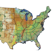
8,360 Reference Plots
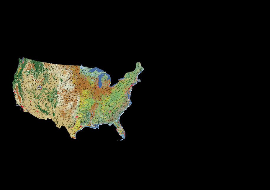
To create the reference dataset, a team of expert image interpreters reviewed Landsat time series imagery, along with other remote sensing data, to assign land cover classifications to 30-by-30-meter plot locations across the lower 48 states. For this release, they reviewed and classified 8,360 plots for every year between 1984 and 2023. That’s 334,400 records in total!
This rich dataset was used to evaluate the accuracy of the first Annual NLCD land cover product release. With this information, users can gain a greater understanding of the strengths and limitations of the data and make more informed decisions about how to use it.
Map shows the locations of the 8,360 plots included in the reference dataset that were used in the accuracy assessment of Annual NLCD CU 1.0 (1985-2023). Each plot includes primary (most likely) and alternate (but could be) land cover labels for 1984 to 2023.
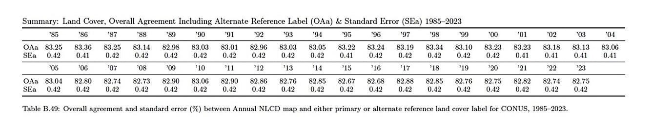
On average, the Annual NLCD land cover matched the expert-reviewed reference data 83% of the time when grouped into broad Anderson Level 1 land cover classes such as forest, shrubland or developed land. Yearly results are provided in the table below.
Related
Learn about the Annual National Land Cover Database (NLCD).

Annual National Land Cover Database
Annual National Land Cover Database Frequently Asked Questions

Eyes on Earth Episode 130 – NLCD Accuracy

Eyes on Earth Episode 126 – Annual NLCD

Annual NLCD Characteristics, Constraints, and Caveats
Eyes on Earth Episode 130 – NLCD Accuracy
Every pixel has a story. At least that’s how land remote sensing scientist Jo Horton sees it. The new Annual National Land Cover Database (NLCD) was just released in October 2024. NLCD is widely used for land cover and change research in the U.S. That’s why the Reference and Validation team provides accuracy metrics to users, and this work allows EROS to move land cover mapping science forward...
Related
Learn about the Annual National Land Cover Database (NLCD).
Annual National Land Cover Database
Annual National Land Cover Database Frequently Asked Questions
Eyes on Earth Episode 130 – NLCD Accuracy
Eyes on Earth Episode 126 – Annual NLCD
Annual NLCD Characteristics, Constraints, and Caveats
Eyes on Earth Episode 130 – NLCD Accuracy
Every pixel has a story. At least that’s how land remote sensing scientist Jo Horton sees it. The new Annual National Land Cover Database (NLCD) was just released in October 2024. NLCD is widely used for land cover and change research in the U.S. That’s why the Reference and Validation team provides accuracy metrics to users, and this work allows EROS to move land cover mapping science forward...