
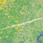
The Chesapeake Bay watershed has experienced substantial population growth over the last several decades. Since 1950, the population has more than doubled, and between 1980 and 2023, the number increased from 12.7 million to 18.6 million.
Annual NLCD Lengthens Land Cover Record to 40 Years
Landsat-based National Land Cover Database Adds 2024 Data
Landsat-based National Land Cover Database Adds 2024 Data
By Earth Resources Observation and Science (EROS) Center
June 25, 2025
The U.S. Geological Survey (USGS) Earth Resources Observation and Science (EROS) Center and the National Land Cover Database (NLCD) project are excited to announce the release of Annual NLCD Conterminous U.S. (CU) Collection 1.1.
With the new release, the USGS builds on the popular Annual NLCD CU Collection 1.0, which debuted in October 2024 and included six annual land cover products for 1985-2023. Collection 1.1 adds 2024 to the temporal extent of Annual NLCD for a total of 40 years of land cover dynamics.
The NLCD project is a joint effort between the USGS and a group of federal agencies known as the Multi-Resolution Land Characteristics (MRLC) Consortium. The group ensures that land cover information is consistent and relevant at the national scale, which can make it invaluable for a variety of resource monitoring and management activities, as well as input to numerous modeling applications.
While Annual NLCD focuses on monitoring the surface of the Earth, it relies on data captured 438 miles up. Satellites in the Landsat Program provide the extensive time series of data required to characterize distinct features and change on the ground.
Media
Sources/Usage: Public Domain. View Media Details
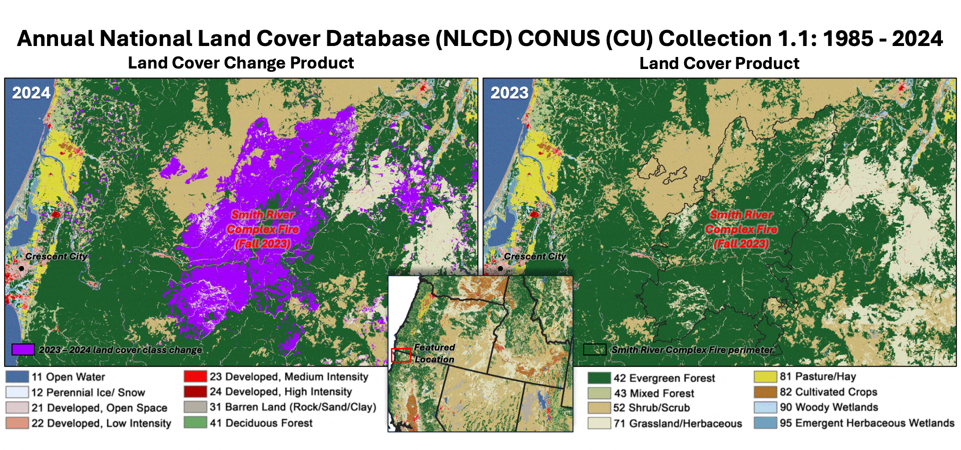
The Annual National Land Cover Database (NLCD) animation above shows how the Smith River Complex Fire, which occurred in the fall of 2023 at the California-Oregon border, left a devastating mark on the landscape. The wildland fire burned nearly 95,000 acres, seen here causing an abrupt transition from evergreen forest to the grassland/herbaceous land cover classification. If the area follows a common wildfire disturbance and regrowth cycle observed in forest systems, it will eventually fill in with shrub/scrub and then return to forest again. The Annual NLCD Land Cover Change product is shown on the left, with the changed area in purple, and the Land Cover product for 2023 flips to 2024 on the right.
Land Cover Characteristics in a Suite of Six Products
Land Cover Characteristics in a Suite of Six Products
Annual NLCD Collection 1.1 adds 2024 to the established suite of six raster-based land use and land cover science products for the conterminous United States. It now covers the period between 1985 and 2024:
- Land Cover – This dataset provides 16 land cover classes such as deciduous and evergreen forest, grassland, cultivated crops and developed.
- Land Cover Change – These data represent annual land cover changes from one year to the next.
- Land Cover Confidence – This layer provides confidence levels for the land cover classifications.
- Fractional Impervious Surface – This component provides the proportion of land covered by developed surfaces, such as roads and rooftops.
- Impervious Descriptor – This feature offers additional information about impervious surfaces by distinguishing between roads and other built surfaces.
- Spectral Change Day of Year – This attribute captures the specific day of the year when significant changes in surface reflectance occur.
Media
Sources/Usage: Public Domain. View Media Details
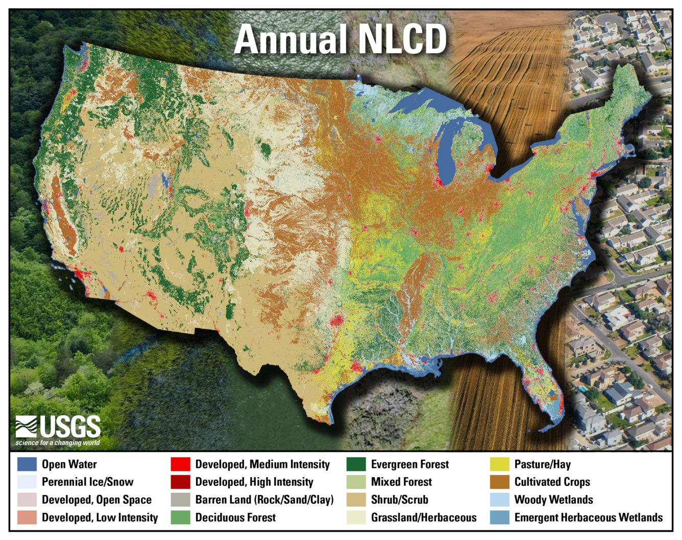
The Annual National Land Cover Database uses 16 land cover classifications, including four for developed areas such as cities and three for forested areas.
The Annual NLCD yearly update strategy was designed to ensure consistency with previous Collection product releases (i.e., 1.0), maintain reliability in time-series analyses and develop products in a resource-efficient manner. Users of the data can expect the core algorithms of Annual NLCD to remain stable throughout the duration of all Collection 1 product releases. Below details what’s new in Collection 1.1:
- All new 2024 data for each of the six products listed above.
- Updated Spectral Change Day of Year products for 2020-2023 to maintain consistency between spectral change characteristics and the downstream land cover products.
- New ancillary file included alongside every Cloud-Optimized GeoTIFF (COG) files for 1985-2024 to populate a more comprehensive raster attribute table.
Get the Data
Get the Data
The Annual NLCD products are available for download on EarthExplorer, the MRLC Web Viewer, the MRLC Mosaic Download website, ScienceBase, as Annual NLCD web services, and through USGS AWS S3 (Oregon us-west-2 region).
For quick and easy change analyses, try out the NLCD Enhanced Visualization and Analysis (EVA) tool.
See more information on the Annual NLCD data access page.
For detailed product descriptions, methodology and data formatting, review the Science Product User Guide.
Have questions about Annual NLCD? Email custserv@usgs.gov.
NLCD Uses
NLCD Uses
NLCD supports thousands of applications in the private, public and academic sectors. It has been used to develop land management policies, assess ecosystem status and health, and examine spatial patterns of biodiversity. It also serves as a critical data layer in national assessments of surface and ground water quality, wildfire monitoring and modeling, conservation efforts and more.
About Annual NLCD
About Annual NLCD
About Annual NLCD
Land Change Examples
Land Change Examples
Land Change Examples
Related
Visit the Annual NLCD website.

Annual National Land Cover Database
Land cover is foundational information for land managers, scientists, and the general public. Many types of scientific studies have applied annual land cover information including projecting future land use, documenting forest fragmentation or conservation practices, modeling wildfire hazards, tracking water quality and quantity, and understanding change in wildlife habitat and ecosystem...
Annual National Land Cover Database Frequently Asked Questions
This page lists commonly asked questions (FAQs) pertaining to Annual National Land Cover Database (NLCD).
Listen to podcast episodes and view a poster and videos related to Annual NLCD.

Annual NLCD for the Chesapeake Bay Region
The Chesapeake Bay watershed has experienced substantial population growth over the last several decades. Since 1950, the population has more than doubled, and between 1980 and 2023, the number increased from 12.7 million to 18.6 million.

Debut of the Annual National Land Cover Database (NLCD)
Debut of the Annual National Land Cover Database (NLCD)Poster introducing the 2023 Annual National Land Cover Database (NLCD). "Development and Cloud Implementation of the New Annual NLCD for the United States." Created by USGS Earth Resources Observation and Science (EROS) Center. Find full PDF here.

Eyes on Earth Episode 130 – NLCD Accuracy
Every pixel has a story. At least that’s how land remote sensing scientist Jo Horton sees it. The new Annual National Land Cover Database (NLCD) was just released in October 2024. NLCD is widely used for land cover and change research in the U.S.
Every pixel has a story. At least that’s how land remote sensing scientist Jo Horton sees it. The new Annual National Land Cover Database (NLCD) was just released in October 2024. NLCD is widely used for land cover and change research in the U.S.

Eyes on Earth Episode 126 – Annual NLCD
In this episode of Eyes on Earth, we talk about the latest release of the National Land Cover Database (NLCD). More than just a map, NLCD is a stack of maps—a database. It has long been the foundational land cover source for scientists, resource managers, and decision-makers across the United States, and now the next generation of USGS land cover mapping is here.
In this episode of Eyes on Earth, we talk about the latest release of the National Land Cover Database (NLCD). More than just a map, NLCD is a stack of maps—a database. It has long been the foundational land cover source for scientists, resource managers, and decision-makers across the United States, and now the next generation of USGS land cover mapping is here.
 National Land Cover Database: Improving on a 30-Year Legacy")
The New Annual (1985-2023) National Land Cover Database: Improving on a 30-Year Legacy
The New Annual (1985-2023) National Land Cover Database: Improving on a 30-Year LegacyThis video is a recording of a previous webinar entitled: “The New Annual (1985-2023) National Land Cover Database: Improving on a 30-year Legacy.” This webinar was recorded on October 24, 2024 at the USGS EROS.
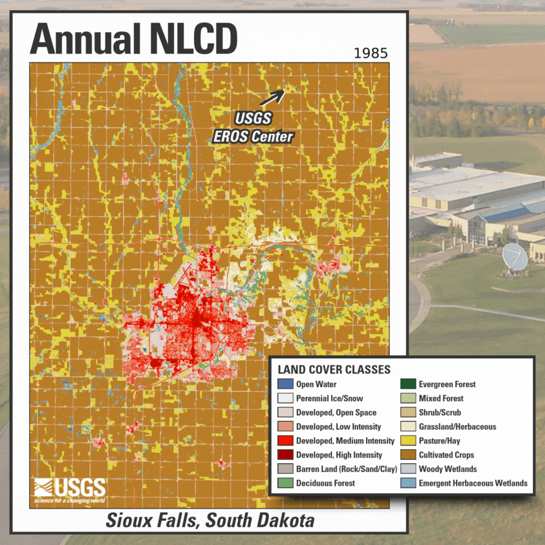
Annual NLCD Animation for Sioux Falls, South Dakota, with Legend
Annual NLCD Animation for Sioux Falls, South Dakota, with LegendAnnual NLCD Animation for Sioux Falls, South Dakota, with photo of the USGS EROS Center in the background. Annual NLCD is a new generation of land cover mapping that offers annual land cover and land change science products nationwide with nearly four decades of data. Learn more here: https://usgs.gov/annualnlcd

Eyes on Earth Episode 107 – EROS 50th: Land Cover, Part 2
Eyes on Earth Episode 107 – EROS 50th: Land Cover, Part 2The National Land Cover Database (NLCD) has a long history as the definitive U.S. land cover product. But the newer Land Change Monitoring, Assessment and Projection (LCMAP) effort takes a longer look back in time.
Read articles about Annual NLCD and examples of the uses of NLCD.
Annual NLCD Collection 1.2 Now Available Annual NLCD Collection 1.2 Now Available
The U.S. Geological Survey (USGS) is excited to announce the release of the Annual National Land Cover Database (NLCD) Conterminous U.S. (CU), Collection 1.2. This release builds on the popular Annual NLCD CU Collection 1.0 by extending the dataset through 2025.
Related
Visit the Annual NLCD website.
Annual National Land Cover Database
Land cover is foundational information for land managers, scientists, and the general public. Many types of scientific studies have applied annual land cover information including projecting future land use, documenting forest fragmentation or conservation practices, modeling wildfire hazards, tracking water quality and quantity, and understanding change in wildlife habitat and ecosystem...
Annual National Land Cover Database Frequently Asked Questions
This page lists commonly asked questions (FAQs) pertaining to Annual National Land Cover Database (NLCD).
Listen to podcast episodes and view a poster and videos related to Annual NLCD.
Annual NLCD for the Chesapeake Bay Region
The Chesapeake Bay watershed has experienced substantial population growth over the last several decades. Since 1950, the population has more than doubled, and between 1980 and 2023, the number increased from 12.7 million to 18.6 million.
The Chesapeake Bay watershed has experienced substantial population growth over the last several decades. Since 1950, the population has more than doubled, and between 1980 and 2023, the number increased from 12.7 million to 18.6 million.
Debut of the Annual National Land Cover Database (NLCD)
Debut of the Annual National Land Cover Database (NLCD)Poster introducing the 2023 Annual National Land Cover Database (NLCD). "Development and Cloud Implementation of the New Annual NLCD for the United States." Created by USGS Earth Resources Observation and Science (EROS) Center. Find full PDF here.
Eyes on Earth Episode 130 – NLCD Accuracy
Every pixel has a story. At least that’s how land remote sensing scientist Jo Horton sees it. The new Annual National Land Cover Database (NLCD) was just released in October 2024. NLCD is widely used for land cover and change research in the U.S.
Every pixel has a story. At least that’s how land remote sensing scientist Jo Horton sees it. The new Annual National Land Cover Database (NLCD) was just released in October 2024. NLCD is widely used for land cover and change research in the U.S.
Eyes on Earth Episode 126 – Annual NLCD
In this episode of Eyes on Earth, we talk about the latest release of the National Land Cover Database (NLCD). More than just a map, NLCD is a stack of maps—a database. It has long been the foundational land cover source for scientists, resource managers, and decision-makers across the United States, and now the next generation of USGS land cover mapping is here.
In this episode of Eyes on Earth, we talk about the latest release of the National Land Cover Database (NLCD). More than just a map, NLCD is a stack of maps—a database. It has long been the foundational land cover source for scientists, resource managers, and decision-makers across the United States, and now the next generation of USGS land cover mapping is here.
The New Annual (1985-2023) National Land Cover Database: Improving on a 30-Year Legacy
The New Annual (1985-2023) National Land Cover Database: Improving on a 30-Year LegacyThis video is a recording of a previous webinar entitled: “The New Annual (1985-2023) National Land Cover Database: Improving on a 30-year Legacy.” This webinar was recorded on October 24, 2024 at the USGS EROS.
Annual NLCD Animation for Sioux Falls, South Dakota, with Legend
Annual NLCD Animation for Sioux Falls, South Dakota, with LegendAnnual NLCD Animation for Sioux Falls, South Dakota, with photo of the USGS EROS Center in the background. Annual NLCD is a new generation of land cover mapping that offers annual land cover and land change science products nationwide with nearly four decades of data. Learn more here: https://usgs.gov/annualnlcd
Eyes on Earth Episode 107 – EROS 50th: Land Cover, Part 2
Eyes on Earth Episode 107 – EROS 50th: Land Cover, Part 2The National Land Cover Database (NLCD) has a long history as the definitive U.S. land cover product. But the newer Land Change Monitoring, Assessment and Projection (LCMAP) effort takes a longer look back in time.
Read articles about Annual NLCD and examples of the uses of NLCD.
Annual NLCD Collection 1.2 Now Available Annual NLCD Collection 1.2 Now Available
The U.S. Geological Survey (USGS) is excited to announce the release of the Annual National Land Cover Database (NLCD) Conterminous U.S. (CU), Collection 1.2. This release builds on the popular Annual NLCD CU Collection 1.0 by extending the dataset through 2025.