
Water Sustainability
Water Sustainability
The New Mexico Water Science Center collects hydrologic and water quality data and conducts studies to understand impacts to water quality, how much water is currently available, how surface water and groundwater interact and affect availability, the rate at which we are using our water resources, and to forecast how much water will be available in the future.
Filter Total Items: 23
Saturated thickness mapping of the Southern High Plains Aquifer in Eastern New Mexico
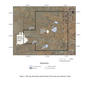
The overall objective of this study is to assist Cannon AFB in understanding and interpreting current and local hydrological conditions by developing an estimate of saturated thickness of the aquifer underlying Cannon AFB and surrounding areas. The Southern High Plains aquifer is the principal source of water for Cannon AFB, the nearby towns of Clovis and Portales, and the local agriculture. The...
Microbial Source Tracking and Escherichia coli Monitoring in the Rio Grande in the South Valley, Albuquerque, New Mexico
The Rio Grande, in southern Albuquerque, is an impaired reach for bacteria. Escherichia coli (E. coli) bacteria are elevated in this reach of the Rio Grande even without stormwater present, during what is referred to as “dry season”. Samples will be collected over a range of flows including during the dry season (November 1st-June30th). Water samples will be analyzed for E. coli and microbial...

Assessment of the Groundwater Resources of the Plains of San Agustin, New Mexico
The groundwater resources of the Plains of San Agustin basin are largely undeveloped, though recent interest in pumping and exporting some of these resources to the Albuquerque metropolitan area has caused uneasiness among some water-resources managers and the public. Protest and concern regarding this appropriation of water resources have been expressed by private, Federal, State, and Tribal...

Ecohydrologic and Water Quality Data Collection at Valle de Oro National Wildlife Refuge and the Albuquerque South Valley Community Commons
The United States Geological Survey (USGS) New Mexico Water Science Center (NM WSC), in cooperation with the U.S. Fish and Wildlife Service (USFWS), U.S. Environmental Protection Agency (USEPA), U.S. Army Corps of Engineers (USACE), U.S. Bureau of Reclamation (Reclamation), Albuquerque Metropolitan Arroyo Flood Control Authority (AMAFCA), and Bernalillo County (BERNCO), will measure and analyze...

Nitrate Contamination in the Albuquerque Basin
Globally, nitrate is the most ubiquitous groundwater contaminate including within the Albuquerque Basin in New Mexico. Ingesting high concentrations of nitrate (> 10 mg/L as N) in drinking water can lead to an increased risk of cancer and in infants, methemoglobinemia. Historical groundwater sampling in Albuquerque and Kirtland Air Force Base have found high (> 10 mg/L as N) and sometime extreme (...

New Mexico Water Science Center Sediment Field Program
Sediment is fragmental material transported by, suspended in, or deposited by water or air, or accumulated in beds by other natural agents. Sediment particles range in size from large boulders to colloidal-size fragments and vary in shape from rounded to angular. They also vary in mineral composition and specific gravity. Sediment is derived from a parent material subjected to erosional processes...

Hydrogeologic and geochemical characterization and evaluation of two arroyos for managed aquifer recharge by surface infiltration in the Pojoaque River Basin
In order to provide long-term storage of diverted surface water from the Rio Grande as part of the Aamodt water rights settlement, managed aquifer recharge by surface infiltration in Pojoaque River Basin arroyos was proposed as an option. The initial hydrogeologic and geochemical characterization of two arroyos located within the Pojoaque River Basin was performed in 2014 and 2015 in cooperation...

Simulation of Pre- and Post-Fire Streamflow in the Upper Rio Hondo Basin, NM
The 2012 Little Bear Fire burned 44,000 acres in the upper Rio Hondo Basin in south-central New Mexico. Landscape in the Basin ranges from mixed conifer forests at higher elevations (12,000 ft) to desert shrubland at lower (5,200 ft) elevations. Burned areas are at risk of substantial post-wildfire erosion and flash floods. USGS post-wildfire analysis estimated 70% of the burned area had a high...

Assessment of Hydrologic Resources and the Potential Effects from Oil and Gas Development in the U.S. Bureau of Land Management Tri-County Planning Area, Sierra, Doña Ana, and Otero Counties, New Mexico
The Tri-County Resource Management Plan/Environmental Impact Statement (RMP/EIS) “decision area” (the public lands and resources that are managed by the Bureau of Land Management in Sierra, Doña Ana, and Otero Counties) is a large (4,375 square miles) and varied landscape. The decision area contains both connected and closed surface-water and groundwater basins, some of which cross state and...

Urban Storm-Water Program in the Albuquerque Metropolitan Area
As part of the surface-water drainage system of the Albuquerque metropolitan area, numerous ephemeral channels collect and transport surface water through the urban area and, eventually, into the Rio Grande.

Rio Grande Transboundary Integrated Hydrologic Model: Modeling Conjunctive Use to Support Resource Management
The Palomas Basin in New Mexico and the Mesilla Basin in New Mexico and Texas and northern Mexico (study area) compose a geologically and hydrologically complex region (figure 1). This region is characterized by conjunctive use of surface water and groundwater that takes place under a myriad of legal and operational constraints, including the Rio Grande Compact, an international treaty, and the...

Upper Rio Grande Basin Focus Area Study
The Upper Rio Grande Basin (URGB) of Colorado, New Mexico, Texas, and northern Mexico was chosen as a focus area study (FAS) for the USGS National Water Census. The conjunctive use of water in the URGB takes place under a myriad of legal constraints including the Rio Grande Compact agreement between the States, an international treaty with Mexico, and several federal water projects. Development of...