
NWIS Mapper

Sources/Usage
Related
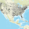
National Water Information System (NWIS) Mapper National Water Information System (NWIS) Mapper
The National Water Information System (NWIS) Mapper provides access to over 1.5 million sites contained in USGS Water Data for the Nation, including sites where current and historical surface-water, groundwater, springs, and atmospheric data has been collected. Users can search by site type, data type, site number, or place.
By
Water Resources Mission Area, Central Midwest Water Science Center, Colorado Water Science Center, Dakota Water Science Center, Maryland-Delaware-D.C. Water Science Center, New England Water Science Center, New Jersey Water Science Center, New Mexico Water Science Center, New York Water Science Center, South Atlantic Water Science Center (SAWSC), Upper Midwest Water Science Center, National Water Quality Laboratory
Related
National Water Information System (NWIS) Mapper National Water Information System (NWIS) Mapper
The National Water Information System (NWIS) Mapper provides access to over 1.5 million sites contained in USGS Water Data for the Nation, including sites where current and historical surface-water, groundwater, springs, and atmospheric data has been collected. Users can search by site type, data type, site number, or place.
By
Water Resources Mission Area, Central Midwest Water Science Center, Colorado Water Science Center, Dakota Water Science Center, Maryland-Delaware-D.C. Water Science Center, New England Water Science Center, New Jersey Water Science Center, New Mexico Water Science Center, New York Water Science Center, South Atlantic Water Science Center (SAWSC), Upper Midwest Water Science Center, National Water Quality Laboratory