
Map of American Samoa and study area of the American Samoa Mapping Project.
Images
Coastal and Marine Hazards and Resources Program images.
Filter Total Items: 2398
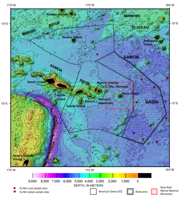
Map of American Samoa and study area
Map of American Samoa and study area of the American Samoa Mapping Project.
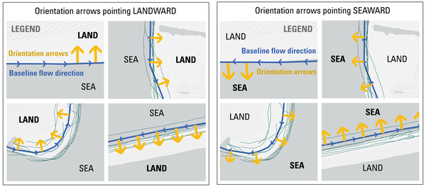
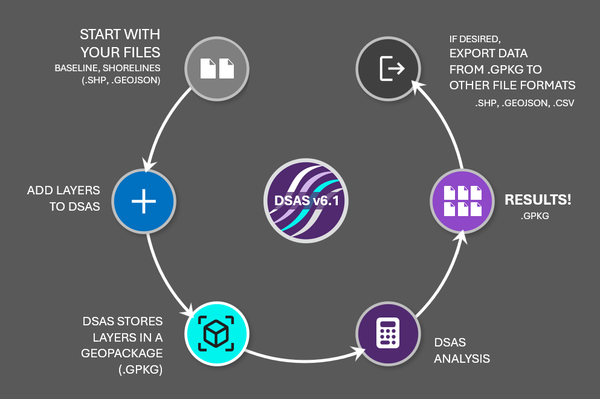
DSAS Landward vs Seaward
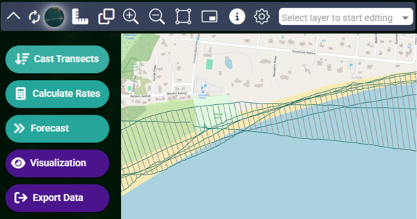
The Digital Shoreline Analysis System (DSAS) version 6 is a standalone application that calculates shoreline or boundary change over time. The GIS of a user’s choice is used to prepare the data for DSAS. Like previous versions, DSAS v.6 enables a user to calculate rate-of-change statistics from multiple historical shoreline positions.
The Digital Shoreline Analysis System (DSAS) version 6 is a standalone application that calculates shoreline or boundary change over time. The GIS of a user’s choice is used to prepare the data for DSAS. Like previous versions, DSAS v.6 enables a user to calculate rate-of-change statistics from multiple historical shoreline positions.
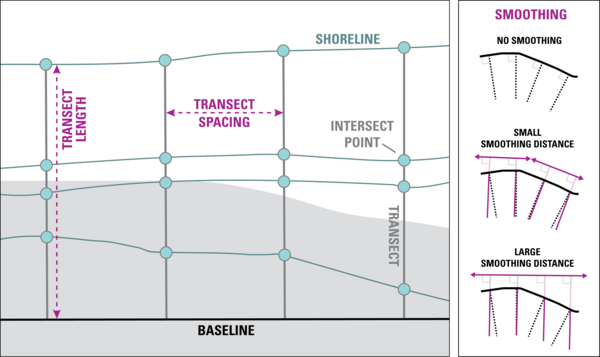
DSAS Elements
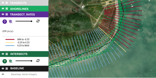
DSAS generates transects that are cast perpendicular to the reference baseline to intersect shorelines at a user-specified spacing alongshore.
DSAS generates transects that are cast perpendicular to the reference baseline to intersect shorelines at a user-specified spacing alongshore.
DSAS Software
The Digital Shoreline Analysis System (DSAS) version 6 is a standalone application that calculates shoreline or boundary change over time. The GIS of a user’s choice is used to prepare the data for DSAS. Like previous versions, DSAS v.6 enables a user to calculate rate-of-change statistics from multiple historical shoreline positions.
The Digital Shoreline Analysis System (DSAS) version 6 is a standalone application that calculates shoreline or boundary change over time. The GIS of a user’s choice is used to prepare the data for DSAS. Like previous versions, DSAS v.6 enables a user to calculate rate-of-change statistics from multiple historical shoreline positions.
DSAS step by step
The Digital Shoreline Analysis System (DSAS) version 6 is a standalone application that calculates shoreline or boundary change over time. The GIS of a user’s choice is used to prepare the data for DSAS. Like previous versions, DSAS v.6 enables a user to calculate rate-of-change statistics from multiple historical shoreline positions.
The Digital Shoreline Analysis System (DSAS) version 6 is a standalone application that calculates shoreline or boundary change over time. The GIS of a user’s choice is used to prepare the data for DSAS. Like previous versions, DSAS v.6 enables a user to calculate rate-of-change statistics from multiple historical shoreline positions.
DSAS Sample Data
The Digital Shoreline Analysis System (DSAS) version 6 is a standalone application that calculates shoreline or boundary change over time. The GIS of a user’s choice is used to prepare the data for DSAS. Like previous versions, DSAS v.6 enables a user to calculate rate-of-change statistics from multiple historical shoreline positions.
The Digital Shoreline Analysis System (DSAS) version 6 is a standalone application that calculates shoreline or boundary change over time. The GIS of a user’s choice is used to prepare the data for DSAS. Like previous versions, DSAS v.6 enables a user to calculate rate-of-change statistics from multiple historical shoreline positions.
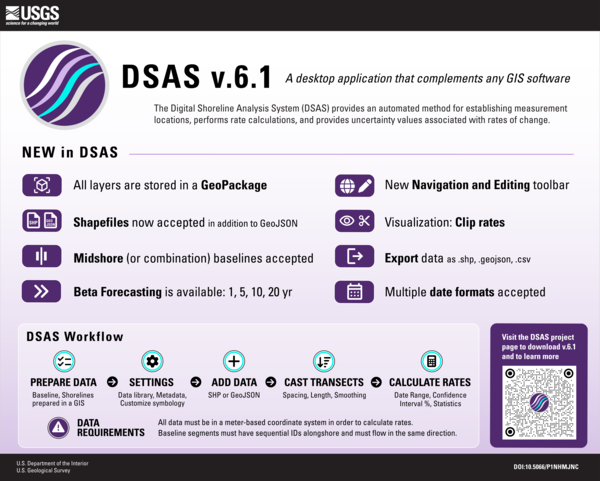
DSAS v6.1 Infographic
The Digital Shoreline Analysis System (DSAS) version 6 is a standalone application that calculates shoreline or boundary change over time. The GIS of a user’s choice is used to prepare the data for DSAS. Like previous versions, DSAS v.6 enables a user to calculate rate-of-change statistics from multiple historical shoreline positions.
The Digital Shoreline Analysis System (DSAS) version 6 is a standalone application that calculates shoreline or boundary change over time. The GIS of a user’s choice is used to prepare the data for DSAS. Like previous versions, DSAS v.6 enables a user to calculate rate-of-change statistics from multiple historical shoreline positions.
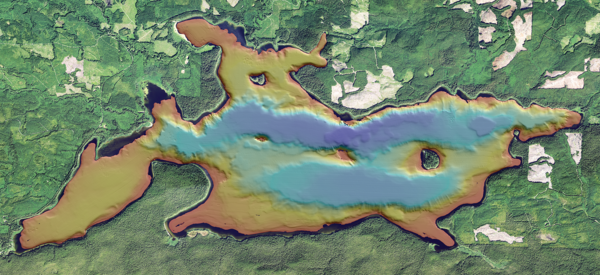
Bathymetric map of Ozette Lake in Washington State
Bathymetric map of Ozette Lake in Washington StateBathymetric map of Ozette Lake in Washington State. Cover image for the Ozette Lake Paleoseismology video.
Bathymetric map of Ozette Lake in Washington State
Bathymetric map of Ozette Lake in Washington StateBathymetric map of Ozette Lake in Washington State. Cover image for the Ozette Lake Paleoseismology video.
Testing DSIM
Testing a USGS patented device (DSIM) and measuring it's performance with a new analytical upgrade recently designed and installed. The DSIM allows for gas samples to be put into a spectrometer and measured in a closed loop, which increased the data signal fidelity, repeatability, and amount an analyte used.
Testing a USGS patented device (DSIM) and measuring it's performance with a new analytical upgrade recently designed and installed. The DSIM allows for gas samples to be put into a spectrometer and measured in a closed loop, which increased the data signal fidelity, repeatability, and amount an analyte used.
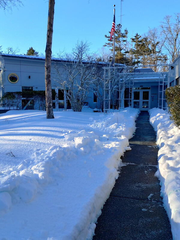
Snow Day
A snow covered science center in Woods Hole, Massachusetts after a powerful nor'easter hit the Cape Cod on January 25, 2026.
A snow covered science center in Woods Hole, Massachusetts after a powerful nor'easter hit the Cape Cod on January 25, 2026.
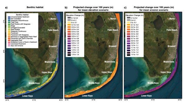
Maps showing FL coral reef degradation
Maps showing FL coral reef degradation, from the study Coral Reef Protection May Help Avert Risks to People, Property, and Economic Activity Caused by Projected Reef Degradation.
Maps showing FL coral reef degradation, from the study Coral Reef Protection May Help Avert Risks to People, Property, and Economic Activity Caused by Projected Reef Degradation.
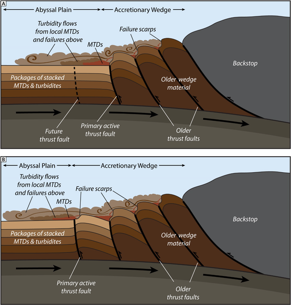
Geologic model for abyssal seismoturbidite generation along the Cascadia Subduction Zone
Geologic model for abyssal seismoturbidite generation along the Cascadia Subduction ZoneGeologic model for abyssal seismoturbidite generation along the Cascadia Subduction Zone. (A) With each earthquake cycle, slope failures occur on the oversteepened limbs of thrust folds in the accretionary wedge, resulting in proximal MTDs and turbidity flows that spread out across the abyssal plain.
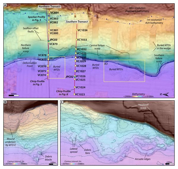
Enlargements of 1-m AUV bathymetry overlain on 30-m bathymetry grid for the study area along the Cascadia Subduction Zone
Enlargements of 1-m AUV bathymetry overlain on 30-m bathymetry grid for the study area along the Cascadia Subduction ZoneEnlargements of 1-m AUV bathymetry overlain on 30-m bathymetry grid for the study area along the Cascadia Subduction Zone. (A) The AUV bathymetry data reveal a 10m high failure scarp that extends for 4km along the seaward face of the frontal thrust fold. Secondary reverse faults observed in the chirp subbottom data are expressed at the seafloor with ~3m offsets.
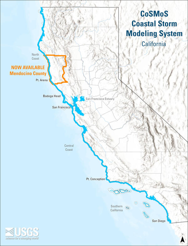
Flood hazard maps for coastal adaptation planning across California now available state-wide
Flood hazard maps for coastal adaptation planning across California now available state-wideUSGS Coastal Storm Modeling System (CoSMoS) flood hazard maps for coastal adaptation planning across California are now available state-wide.
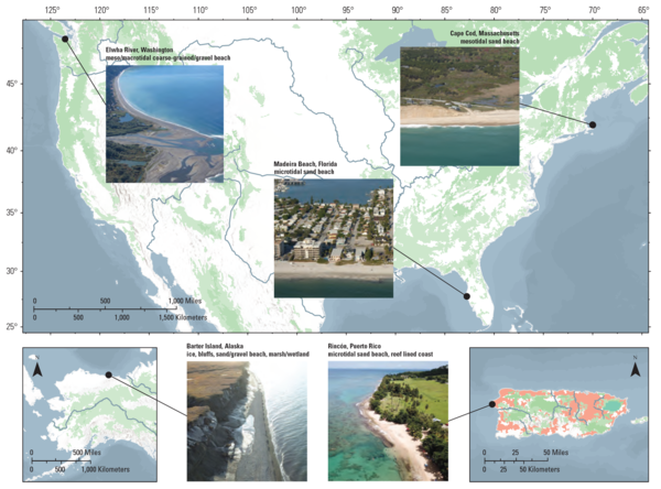
Comparisons of Shoreline Positions from Satellite-Derived and Traditional Field- and Remote-Sensing Techniques
Comparisons of Shoreline Positions from Satellite-Derived and Traditional Field- and Remote-Sensing TechniquesMaps of five study sites spread across the conterminous United States, Alaska, and the Island of Puerto Rico and descriptions of each site’s coastal setting. From the study Comparisons of Shoreline Positions from Satellite-Derived and Traditional Field- and Remote-Sensing Techniques.
Cover image for Hawai'i Abyssal Nodules Expedition video
Cover image for Hawai'i Abyssal Nodules Expedition videoIn Fall 2025 the Hawaiʻi Abyssal Nodules and Associated Ecosystems Expedition, led by USGS scientists, will investigate the geology, minerals, and environmental setting of the deep seabed offshore Moku o Keawe (Hawaiʻi Island) in the U.S. Exclusive Economic Zone. This work is part of ongoing collaborative efforts with BOEM and NOAA.
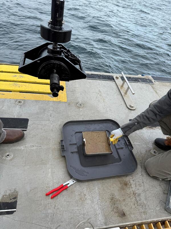
Grain-size analysis
Shipek grab sampler and sediment sample. Image is included in USGS data release, "Grain-size analysis of sediment samples collected in the nearshore zone offshore of Marconi Beach, Wellfleet, MA, December 9, 2024."
Shipek grab sampler and sediment sample. Image is included in USGS data release, "Grain-size analysis of sediment samples collected in the nearshore zone offshore of Marconi Beach, Wellfleet, MA, December 9, 2024."
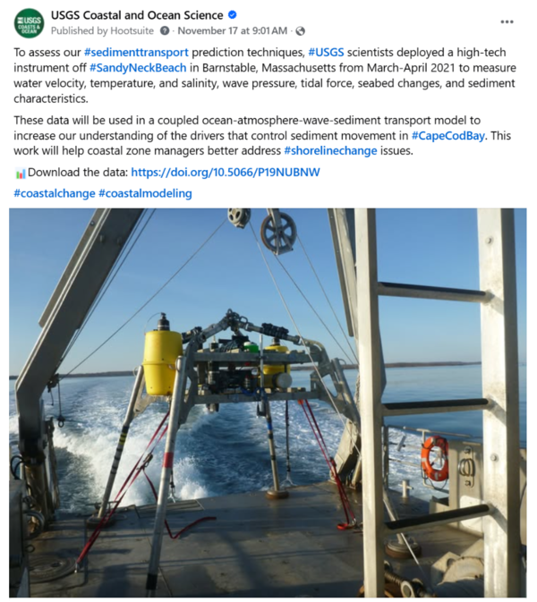
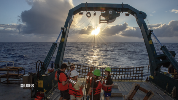
Social Media: Sediment Movement in Cape Cod Bay
To assess our #sedimenttransport prediction techniques, #USGS scientists deployed a high-tech instrument off #SandyNeckBeach in Barnstable, Massachusetts from March-April 2021 to measure water velocity, temperature, and salinity, wave pressure, tidal force, seabed changes, and sediment characteristics.
To assess our #sedimenttransport prediction techniques, #USGS scientists deployed a high-tech instrument off #SandyNeckBeach in Barnstable, Massachusetts from March-April 2021 to measure water velocity, temperature, and salinity, wave pressure, tidal force, seabed changes, and sediment characteristics.
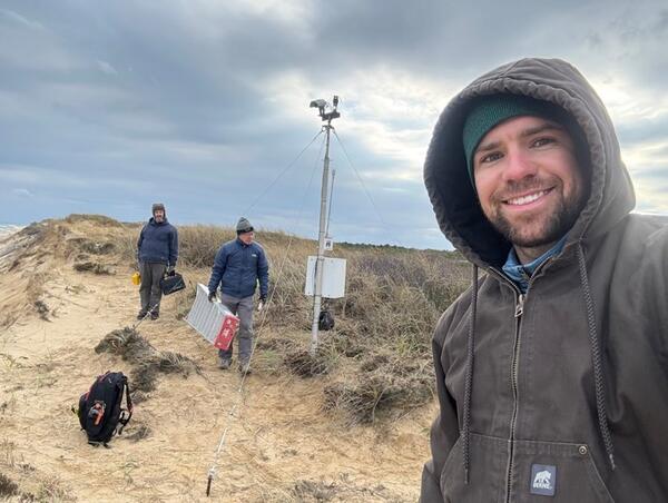
Marconi Beach CoastCam Maintenance
The USGS uses a nationwide network of coastal observing cameras (CoastCams) to monitor coastal conditions in near real-time and support research on a variety of coastal processes and hazards.
The USGS uses a nationwide network of coastal observing cameras (CoastCams) to monitor coastal conditions in near real-time and support research on a variety of coastal processes and hazards.
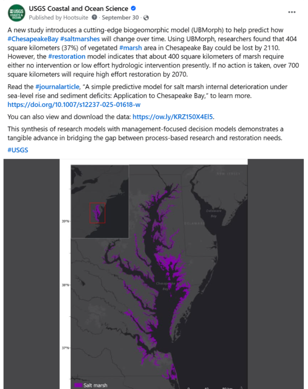
Social Media: Biogeomorphic salt marsh model
A new study introduces a cutting-edge biogeomorphic model (UBMorph) to help predict how #ChesapeakeBay #saltmarshes will change over time. Using UBMorph, researchers found that 404 square kilometers (37%) of vegetated #marsh area in Chesapeake Bay could be lost by 2110.
A new study introduces a cutting-edge biogeomorphic model (UBMorph) to help predict how #ChesapeakeBay #saltmarshes will change over time. Using UBMorph, researchers found that 404 square kilometers (37%) of vegetated #marsh area in Chesapeake Bay could be lost by 2110.