An official website of the United States government
Here's how you know
Official websites use .gov
A .gov website belongs to an official government organization in the United States.
Secure .gov websites use HTTPS
A lock () or https:// means you’ve safely connected to the .gov website. Share sensitive information only on official, secure websites.
Since inception, the Landsat program has been an important component of U.S. foreign policy and science and technology strategies. Fifty years on, international collaboration and cooperation remain a bedrock value for the USGS and its remote sensing partners around the world.
Scientists, engineers and program managers representing 11 of the countries within the Landsat International Ground Station (IGS) Network pose for a photo near a display designed to honor the role of International Cooperators in the Landsat mission. The permanent display was installed in the lobby of the USGS Earth Resources Observation and Science (EROS) Center near Sioux Falls, SD in advance of a 2019 meeting of the Landsat Technical Working Group.
The program’s longstanding network of International Cooperators (ICs), which operate numerous International Ground Stations (IGSs) around the world, embodies the U.S.’s policy of peaceful use of outer space and the worldwide dissemination of civil space technology to improve societal decision-making from national governments to local citizens. Currently there are 18 actively operating IGSs spanning 12 countries around the world, each providing essential dimension to the joint USGS and NASA agency Landsat mission. The reception capabilities of each station augment data collection capacity of the Landsat system, above and beyond that provided by the satellite on-board recorders and the Landsat Ground Network (LGN).
The historical Landsat data downlinked to the IGSs are currently being added to the USGS Landsat archive by way of the Landsat Global Archive Consolidation (LGAC) initiative. For Landsat 8 (and eventually Landsat 9), all data downlinked to IGSs are also written to the satellite on-board recorder and downlinked to the LGN for inclusion in the USGS Landsat archive. Therefore, during nominal Landsat mission operations no unique data are held at the IGSs. However, the Landsat IGSs provide contingency data collection capacity to the LGN in the event of a spacecraft anomaly or malfunction. Additionally, the expertise of ICs in applying Landsat data to local and regional user needs can facilitate further USGS scientific and application development for Landsat data in the U.S. and worldwide.
The USGS meets with the Landsat ICs twice per year to discuss operational management and technical matters through the Landsat Ground Station Operators Working Group (LGSOWG) and Landsat Technical Working Group (LTWG) meetings. These meetings are an essential forum for global Landsat cooperation and collaboration.
Much of the data held internationally are unique, relative to each station's area of coverage and were not duplicated in the USGS archive.
In 2010, the Landsat Global Archive Consolidation (LGAC) effort began, with a goal to consolidate the Landsat data archives of all international ground stations, make the data more accessible to the global Landsat community, and significantly increase the frequency of observations over a given area of interest to improve scientific uses such as change detection and analysis.
Bringing Landsat data from many collection stations worldwide to one archive includes several challenges:
Various data formats and processing methods
Unknown data formats and processing methods (stations no longer active)
Media storage age and conditions
Various or obsolete technologies used to ingest data
While every technology asset available will be explored, some data unfortunately may be irrecoverable.
As this effort to systematically acquire, reconcile, and ingest all recoverable foreign data continues, all data successfully ingested into the USGS Landsat archive become available on EarthExplorer, or GloVis.
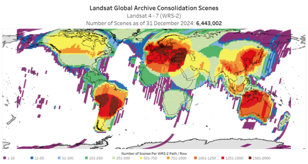
The maps below display Landsat scenes received from International Ground Stations. The WRS-2 map displays Landsat 7 ETM+, Landsat 4-5 TM, and Landsat 4-5 MSS data received. The WRS-1 map displays Landsat 1-3 MSS data received.
This video gives an overview of what it mean to be an International Cooperator, including information on what is an International Cooperator, who represents the International Cooperator community, what are the benefits of being an International Cooperator, and what does it mean to be an International Cooperator. View the audio-described version.
Eyes on Earth Episode 61 - Landsat 9 Launch Part 2
Hundreds of scientists, officials, international representatives, and others witnessed the launch of Landsat 9 on September 27, 2021, from a handful of viewing sites around Santa Barbara County, California.
Hundreds of scientists, officials, international representatives, and others witnessed the launch of Landsat 9 on September 27, 2021, from a handful of viewing sites around Santa Barbara County, California.
The St. Mary and Milk Rivers cross the U.S. and Canadian border and supply water to both countries. Managing that resource in the interest of both nations is a matter of international collaboration and cooperation, and Landsat data is helping offer objective information on water use.
The St. Mary and Milk Rivers cross the U.S. and Canadian border and supply water to both countries. Managing that resource in the interest of both nations is a matter of international collaboration and cooperation, and Landsat data is helping offer objective information on water use.
The continent of Australia experienced some of the most devastating wildfires in its history in late 2019 and early 2020. Remote sensing scientists in Australia, who collaborate closely with EROS, relied on satellites like Landsat to help assess and monitor the damage.
The continent of Australia experienced some of the most devastating wildfires in its history in late 2019 and early 2020. Remote sensing scientists in Australia, who collaborate closely with EROS, relied on satellites like Landsat to help assess and monitor the damage.
Eyes on Earth Episode 18 — Landsat's International Partners
Across the planet, in rural settings on uncluttered landscapes, there are satellite antennas receiving data directly from Landsat satellites as they pass 438 miles overhead at more than 17,000 miles per hour. It happens multiple times a day, in Australia, Brazil, Canada, Germany, South Korea, and elsewhere.
Across the planet, in rural settings on uncluttered landscapes, there are satellite antennas receiving data directly from Landsat satellites as they pass 438 miles overhead at more than 17,000 miles per hour. It happens multiple times a day, in Australia, Brazil, Canada, Germany, South Korea, and elsewhere.
This video gives an overview of what it mean to be an International Cooperator, including information on what is an International Cooperator, who represents the International Cooperator community, what are the benefits of being an International Cooperator, and what does it mean to be an International Cooperator.
This video gives an overview of what it mean to be an International Cooperator, including information on what is an International Cooperator, who represents the International Cooperator community, what are the benefits of being an International Cooperator, and what does it mean to be an International Cooperator.
What It Means to be an International Cooperator (AD version)
This video gives an overview of what it mean to be an International Cooperator, including information on what is an International Cooperator, who represents the International Cooperator community, what are the benefits of being an International Cooperator, and what does it mean to be an International Cooperator.
This video gives an overview of what it mean to be an International Cooperator, including information on what is an International Cooperator, who represents the International Cooperator community, what are the benefits of being an International Cooperator, and what does it mean to be an International Cooperator.
Landsat missions have always been an important component of U.S. foreign policy, as well as science and technology policy. The Landsat program’s longstanding network of International Cooperators (ICs), which operates numerous International Ground Stations (IGS) around the world, embodies the United States’ policy of peaceful use of outer space and the worldwide dissemination of civil...


")