2025 In Review: Highlighting the Best of Landsat
Milestones Continue the Mission's Legacy
LANDSAT AT WORK: Transforming Data Into Solutions
Stories that highlight how Landsat data is put into practice to inform decisions that help safeguard lives, property, and natural resources.
Landsat and the Earth Resources Observation and Science (EROS) Center
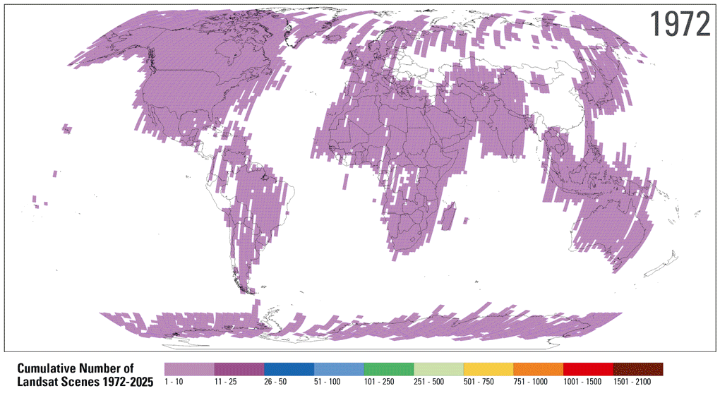
EROS is one of the largest civilian archives of land images in the world
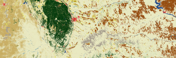
Annual National Land Cover Database (NLCD)
Products based on Landsat data provide timely, long-term, and detailed land surface change information
Landsat's Economic Value Increases to 25.6 Billion in 2023
A new report details a substantial increase in societal benefits
Landsat Products and Services from the USGS
An Interactive Way to Learn About Landsat
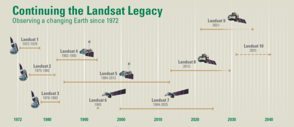
Landsat Missions
Since 1972, Landsat satellites have continuously acquired images of the Earth’s land surface, providing uninterrupted data to help land managers and policymakers make informed decisions about natural resources and the environment. Data acquired by Landsat satellites are distributed from the USGS Earth Resources Observation and Science (EROS) Center in Sioux Falls, South Dakota.
Landsat Continuity has always been central to the program’s success. This includes (1) maintaining historic sensor compatibility to support long-term time series analyses, (2) ensuring consistent image quality to reduce uncertainties in land surface measurements, and (3) evolving satellite observations and data products to meet changing priorities and national needs.
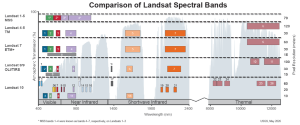
Landsat Collections

Landsat Collections are tiered management structures that ensure all Landsat Level-1 products are produced to create a consistent archive of known data quality
Science Products

Landsat Level-2 and Level-3 Science Products, along with U.S. Analysis Ready Data (ARD), contain higher-level data to allow scientists to better document changes to Earth's terrestrial environment.
Project Information
There is a wealth of technical information and statistics about the Landsat Project, Landsat data, and Landsat science products. Statistics about Landsat data availability, distribution and usage are updated quarterly.
- Explore project documents about policy, data, systems and more
- Discover project statistics about the USGS Landsat data archive
- Learn about the Landsat Ground Network Stations (LGN)
News about Landsat
Find the latest news about Landsat missions, data products, data access, and related topics.
- Read all Landsat Mission Headlines
- Subscribe to the Latest in Landsat Newsletter
- Subscribe to Landsat Headlines RSS Feeds
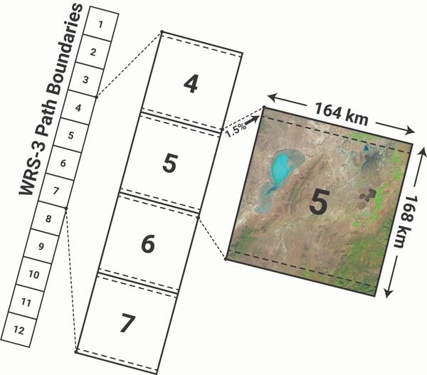
Landsat Products and Data Access
Landsat data products are continually being matured into the highest quality possible. These products allow scientists to provide improved and more useful results for land change and use analysis. Landsat data products held in the USGS archives can be searched and downloaded at no charge from a variety of data portals.
Useful Tools & Viewers
Various files, tools, converters, and information to better understand Landsat acquisition and how to search for Landsat data and products.
- Open the Landsat Acquisition Calendar Tool
- Open the Spectral Characteristics Viewer
- Open the Landsat Path/Row - Latitude/Longitude Conversion Tool
- Open the Landsat Archive Dashboard
International Collaboration
Landsat has always been an important component of U.S. foreign policy, science, and technology policy. A longstanding network of International Cooperators operate numerous International Ground Stations allowing direct reception and downlink from Landsat satellites. In 2010, International Cooperators started the effort to consolidate Landsat data acquired at worldwide ground station to the USGS archive.
- Learn about the Landsat International Ground Station (IGS) Network
- Learn about Landsat Global Archive (LGAC) efforts
Education and Outreach Resources
Landsat education and outreach resources can be used by students, teachers and the general public to further understand the fundamentals of remote sensing, Landsat technology, and how practical applications of Landsat data are helping specialists manage Earth's natural resources for a growing world population.
- View Frequently asked Questions (FAQs)
- Open Landsat Fact Sheets
- Listen to Eyes on Earth episodes about Landsat
- Explore Landsat Interactive Webpages
Join us on Social!
News
Annual NLCD Collection 1.2 Now Available
Latest in Landsat June 2026 - Vol. 5 | Issue 6
USGS Seeks Industry Input on Landsat 10 Mission Operations Center and Flight Operations
Publications
Quantifying Landsat’s contributions to U.S. agricultural and forestry applications Quantifying Landsat’s contributions to U.S. agricultural and forestry applications
ECCOE Landsat quarterly calibration and validation report—Quarter 4, 2025 ECCOE Landsat quarterly calibration and validation report—Quarter 4, 2025
Landsat 8–9 geometric and radiometric calibration and characterization Landsat 8–9 geometric and radiometric calibration and characterization
Science
Eyes on Earth Episode 137 – Landsat Takes Yellowstone’s Temperature

Eyes on Earth Episode 136 – The EROS Test Site