
Landsat Acquisitions
The Landsat 8 and Landsat 9 satellites together acquire over 1,500 scenes each day. On this page you can learn how acquisitions are determined, what will be acquired each day, and how special acquisition requests are made.


How Landsat Acquisitions are Determined
Landsat 8 and Landsat 9 Earth imaging acquisitions are guided by their respective Long Term Acquisition Plan (LTAP). The LTAP is structured around the Worldwide Reference System-2 (WRS-2) grid, which partitions Landsat swath imaging of the Earth into ~185 × 180 km scenes using a path/row notation. The LTAP utilizes parameters such as seasonality, land definition, historical cloud cover, gain settings, and sun angle to determine the daily acquisition schedule.
Under normal operations, nearly all day-lit imaging opportunities defined by the LTAP descending orbit are routinely scheduled for both satellites - exceptions are made when there is an emergency imaging request or risk mitigation maneuver. A scene is considered day-lit when the solar elevation at scene center is at least 5 degrees above the horizon.

The USGS Landsat Multi-Satellite Operations Center (LMOC) oversees and ensures that Landsat 8 and Landsat 9 image acquisitions are scheduled and acquired. In addition to acquisition planning, the LMOC manages on-orbit calibration planning activities, and periodic orbit maintenance operations, such as inclination burns or drag makeup maneuvers.
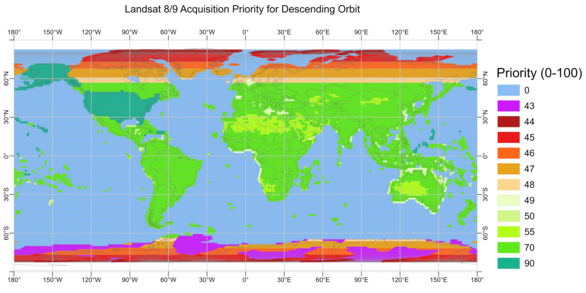
Each day, the LMOC assigns a priority to each Landsat 8 and Landsat 9 scene scheduled to be acquired (collectively known as the day’s candidate scenes), based on each satellite’s LTAP priority assignments. These assignments help optimize acquisitions by taking into account the scheduled acquisitions, as well as any special requests that may be received from the user community. Lower priority scenes (shown as purple and red in the map above) are more likely to be rejected during scheduling, while the higher priority scenes (shown in green, yellow, and orange) are only rejected for spacecraft maneuvers or rare calibration events.
The LTAPs direct that the following acquisitions be made:
- Over 99 percent of descending day-lit continental land and near-shore coastal images between 57°N (Row 21) and 57°S (Row 104) latitudes, where the side lap area between adjacent paths is less than 50%. These path/row locations have a request priority value of 55 to 90 in the LTAP database.
- Over 91 percent of the descending and ascending day-lit continental land and near-shore coastal images north of 57°N and south of 57°S degrees latitude with a decreasing priority that is inversely proportional to the amount of side lap area between adjacent paths. These path/row locations have request priority of 43 to 48.
- Over 99 percent of open water scenes that complete continental land intervals (e.g., the Mediterranean, Baltic, and Caribbean seas). These path/row locations have a request priority of 49 or 50.
- Ascending nighttime, open ocean, and Landsat Extended Acquisitions of the Poles (LEAP) scenes are only acquired by special request where the 5 degree sun elevation imaging constraint embedded within the LTAP can be disabled to enable low or no illumination imaging.
Landsat 8 and 9 are operated in a near-polar sun-synchronous orbit with a nominal ~10:12 a.m. mean local time equatorial crossing on the descending node of each orbit. At high latitudes and polar regions during hemispheric summer months, the sun remains continuously above the horizon, often referred to as ‘polar day’ or the ‘midnight sun’. This extended illumination offers the opportunity to image these latitudes on both descending and ascending orbits (often referred to as nighttime imaging).
Access The Landsat 8/9 Long Term Acquisition Plan for Earth’s continental landmasses and near-shore coastal zones, Version 1.0 Data Release (2025) to view the Ascending (nighttime) orbit priority map and learn more about the Landsat 8 and Landsat 9 LTAP.
Special Requests for Future Landsat Acquisitions
Special requests can be made for the acquisition of Landsat 8 or Landsat 9 scenes that do not fall within the candidate images acquired by the logic defined in the information described above. Special requests are only needed to acquire night, low sun elevation, ocean, and ascending day-lit data, or for emergency response operations. All attempts will be made to accommodate emergency requests over other high priority activities. However, most activities, such as spacecraft maneuvers, are required and cannot be changed to acquire data.
Single Path/Row Request Form – Complete and submit this form for requests that fall in one path/row. If you have multiple paths/rows please submit them using the Multiple Path/Row Request Form below.
Multiple Path/Row Request Form – Download and complete this form for requests encompassing more than one path/row range, and send it to custserv@usgs.gov. With your email, you can also include a list of path/rows in a .csv format. Example file for multiple paths/rows
When you submit your requests, you will be notified when they are received. After review, you will receive another email notifying you if your request was denied or approved.

Worldwide Reference Systems
After the launch of Landsat 1 in 1972, nations around the world utilized the Landsat data, but there was no conventional labeling system for how scenes were acquired. To catalog Landsat imagery collected over Canada, the Canada Centre for Remote Sensing (CCRS) created a series of grid paths across their country drawn parallel to latitude lines. The USGS later adopted this schema, and extended the reference to the entire surface of the planet. This grid reference system became known as the Worldwide Reference System (WRS-1). After the expansion, the WRS-1 grid included 251 paths and 119 rows, where each intersection of a path and a row denotes the nominal center of a Landsat scene. This reference system provided an 18-day repeat cycle for the Landsat 1, Landsat 2, and Landsat 3 satellites.
Since the launch of Landsat 4 in 1982, the Worldwide Reference System-2 (WRS-2) has been in use. The WRS-2 grid has 233 paths and 123 rows, with a 16-day repeat cycle per satellite. The Landsat 8 and Landsat 9 satellites have an 8-day offset.
Landsat Maneuvers
In order to maintain a consistent equatorial crossing time, the Landsat spacecrafts must occasionally undergo maneuvers using the satellite's propulsion subsystem to fire thrusters and bring about a change in the orbital elements. When maneuvers are executed, science imaging may be briefly suspended. Please see the Landsat 8 & 9 maneuver webpage and the Landsat 7 maneuver webpage for additional information.
Landsat 7 Acquisitions
NOTE: The information in this section is for historical reference only.
After Landsat 8 launched in 2013, Landsat 7 started to acquire data based on a continental acquisition strategy, in which data over Antarctica, oceanic islands, Greenland, and Row 9 and above were no longer acquired systematically.
Starting April 6, 2022, Landsat 7 acquisitions were suspended to allow for a series of spacecraft burns to lower the satellite’s orbit by 8 kilometers (km) (learn more about this activity). After a series of maneuvers lowered the satellite out of the standard 705km WRS-2 orbit, Landsat 7 imaging resumed on May 5, 2022 at a lower orbit of 697 km. The USGS elected to continue science data acquisition from the Enhanced Thematic Mapper Plus (ETM+) to assess the utility of imagery collected at the new lower orbit and earlier equatorial crossing time. Initially, it was decided to collect data through September 2022 to capture the Northern Hemisphere growing season. However, since the health of the satellite and the ETM+ sensor remained steady, and the quality of the data remained nominal, data acquisitions continued until January 2024.
On January 19, 2024, Landsat 7 imaging was suspended due to the satellite’s transition into full sunlight, which caused issues with the batteries. Imaging was suspended to retain the health and safety of the batteries. Visit the January 19th News page describes more about how being in full sunlight affects the satellite, and why data imaging was suspended. The Landsat 7 mission was decommissioned in June 2025.