
The Landsat series of Earth-observing satellites has been continuously acquiring land surface imagery since 1972. Over 10 million Landsat scenes are currently available for download. They are also accessible from a cloud environment, in a cloud optimized format that gives you more flexible, customized access.
Landsat Project Statistics
How much Landsat data is available, and how much is downloaded? Who downloads Landsat products and what do they use it for?
We answer these questions and more on this page.
Each day, about 1 terabyte (TB) of new Landsat mission data is acquired and downlinked to the Landsat Ground Network station at the USGS Earth Resources Observation and Science (EROS) Center in Sioux Falls, South Dakota. After being received, the data are processed into Landsat products that add about 3 TB to the USGS EROS archive daily.
The 2020 introduction of Landsat Collection 2 data ‘in the cloud’ has changed how users access and download Landsat products. Instead of downloading entire scenes, users can now download individual bands or access and analyze only the metadata. As a result, it no longer makes sense to measure downloads by the number of scenes. Moving forward, we will measure data access in terms of data volume. As the USGS data holdings and access possibilities evolve, so will the information we provide on this page.
Citation/Credit statement: Whether you are a researcher, land manager, or simply an enthusiast of satellite imagery, the information presented here offers valuable insights into how Landsat data is being used. These graphics are freely available for use. Please credit the USGS as follows: “Graphics and data provided courtesy of the USGS” and include a link back to this webpage with your citation.
The information on this page is updated quarterly or as requested. Last update: June 2026
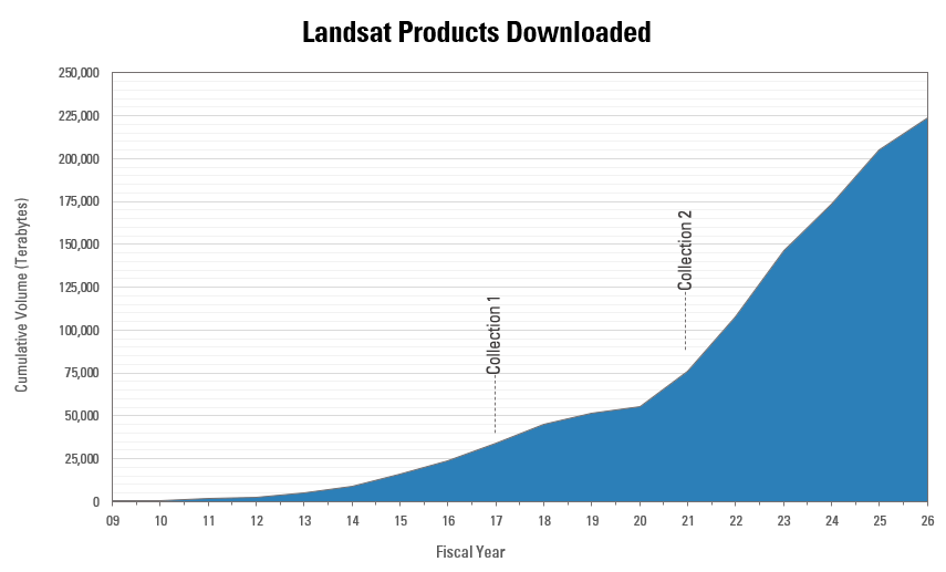
Landsat product download volume
The cumulative volume of all operational Landsat products downloaded from the USGS EROS Landsat archive since December 2008 (FY 2009) is shown below. Prior to 2008, use of Landsat data was limited due to the high price of each scene, often making it difficult for many users — particularly researchers, educators, and smaller organizations — to afford consistent access to the data. However, when the USGS announced in early 2008 that Landsat data would be made available to the public free of charge, this significantly expanded access and enabled broader use for science research and better-informed land management decisions.
The graphic is comprised of the volume of data downloaded from the following Landsat products:
- Level-1 scene products
- Level-2 scene science products
- U.S. Analysis Ready Data (ARD) tiled products
- Level-3 tiled burned area, dynamic surface water extent, and fractional snow covered area science products
Media
Sources/Usage: Public Domain. View Media Details
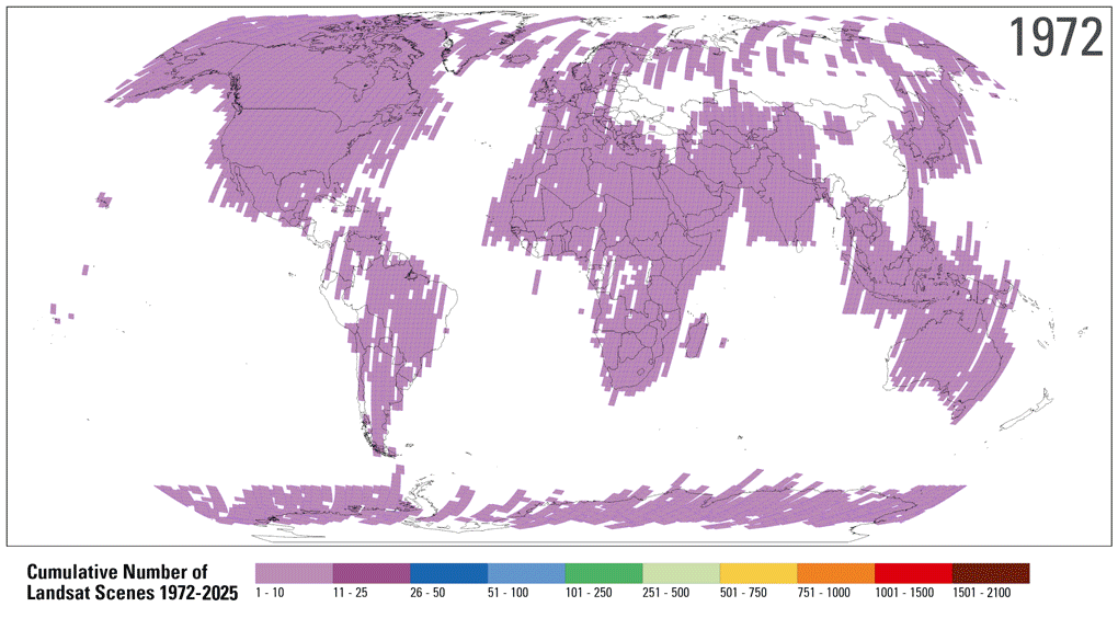
Visualizing Landsat Level-1 scene products
This animation displays the density of the Landsat Level-1 scene products acquired from 1972 to 2023 that are available for download from the USGS Landsat Archive.
Over the years, Landsat’s data collection strategy has evolved from targeted acquisitions to systematically collecting imagery over all global land masses. This comprehensive coverage ensures a continuous and complete record of Earth's surface, capturing changes in land use and land cover over time.
Visit the Landsat Archive Dashboard to create maps that display Landsat scene products based on satellite, sensor, year, or processing level. The geographic areas of acquired ascending (nighttime) scenes are also available.
Media
Sources/Usage: Public Domain. View Media Details
Available Landsat scene products
The graphics below display the growth of Landsat Collection 2 Level-1 and Level-2 scene products available from the USGS Landsat Archive. Landsat products continue to be added to the archive through the Landsat Global Archive Consolidation (LGAC) program. This ongoing effort ensures that valuable historical data is preserved and made available for users. Landsat Level-2 science products (surface reflectance and surface temperature) were first introduced with the Collection 2 release in December 2020.
Visit the Landsat Archive Dashboard to access an interactive display of available Landsat scene products.
Media
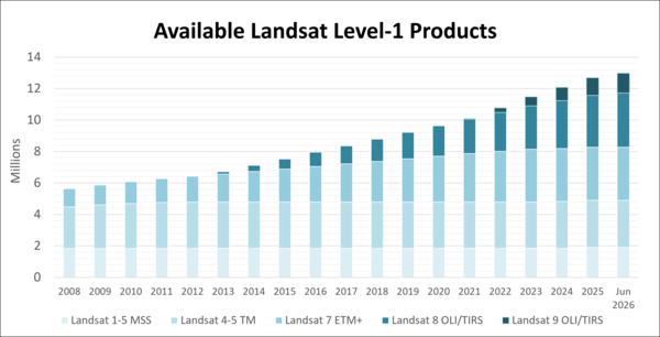
This graph shows the number of Landsat Collection 2 Level-1 scene-based products that are available for download from the USGS Archive. (Click to enlarge)
Sources/Usage: Public Domain. View Media Details
Media
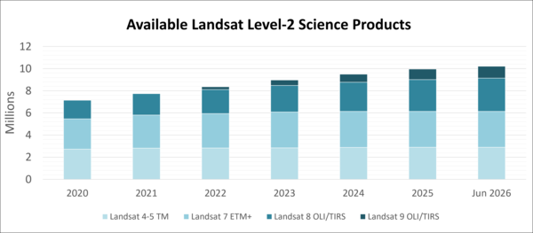
This graphic displays the number of Landsat Collection 2 Level-2 scene-based science products that are available for download from the USGS Archive. (Click to enlarge)
Sources/Usage: Public Domain. View Media Details
How are Landsat Data Used?
Landsat Data Users represent a variety of industries. This graph displays the percentage of data accessed by each industry, based on USGS EROS Registration Service (ERS) unique user accounts.
Media
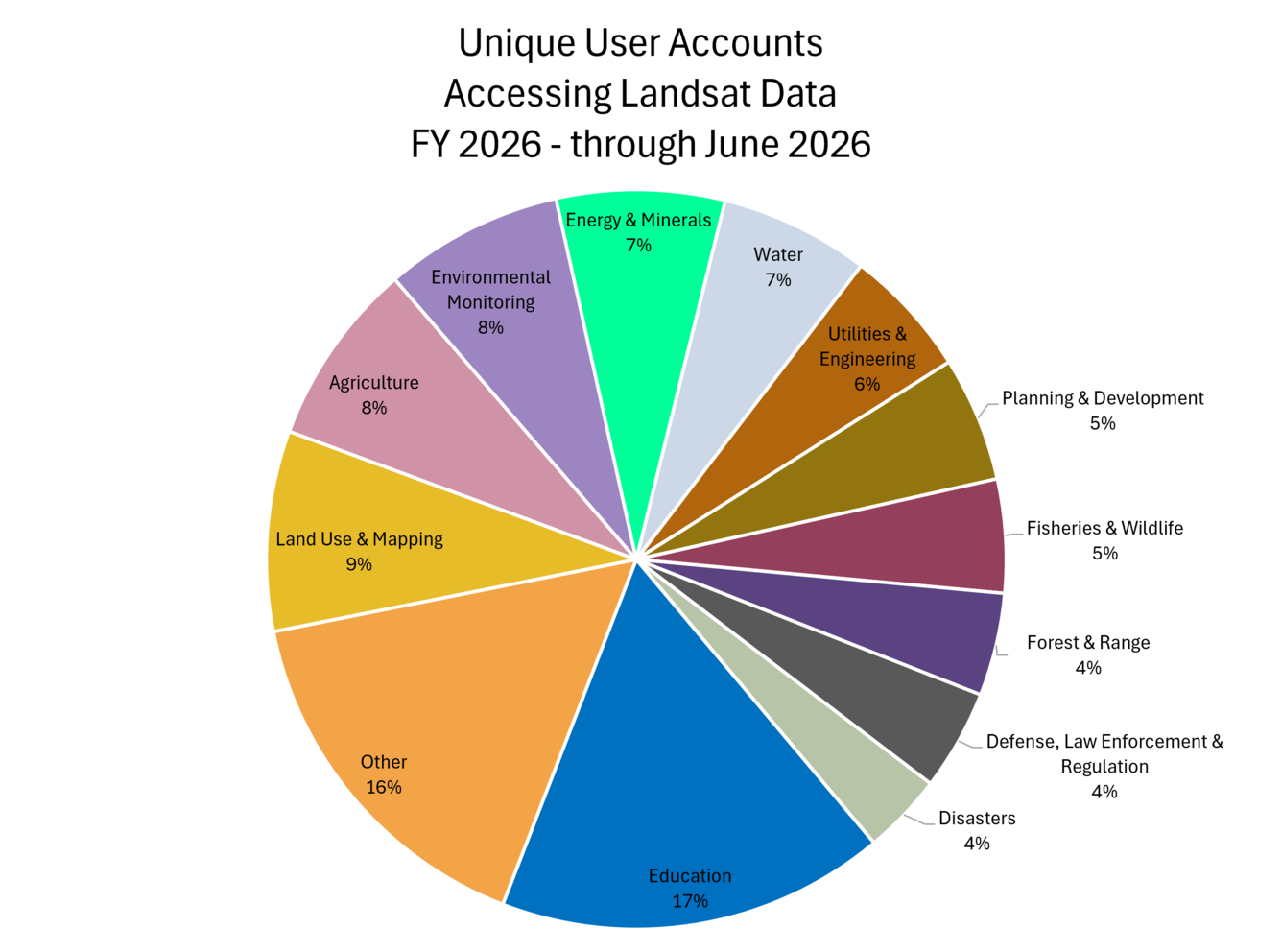
Sources/Usage: Public Domain. View Media Details
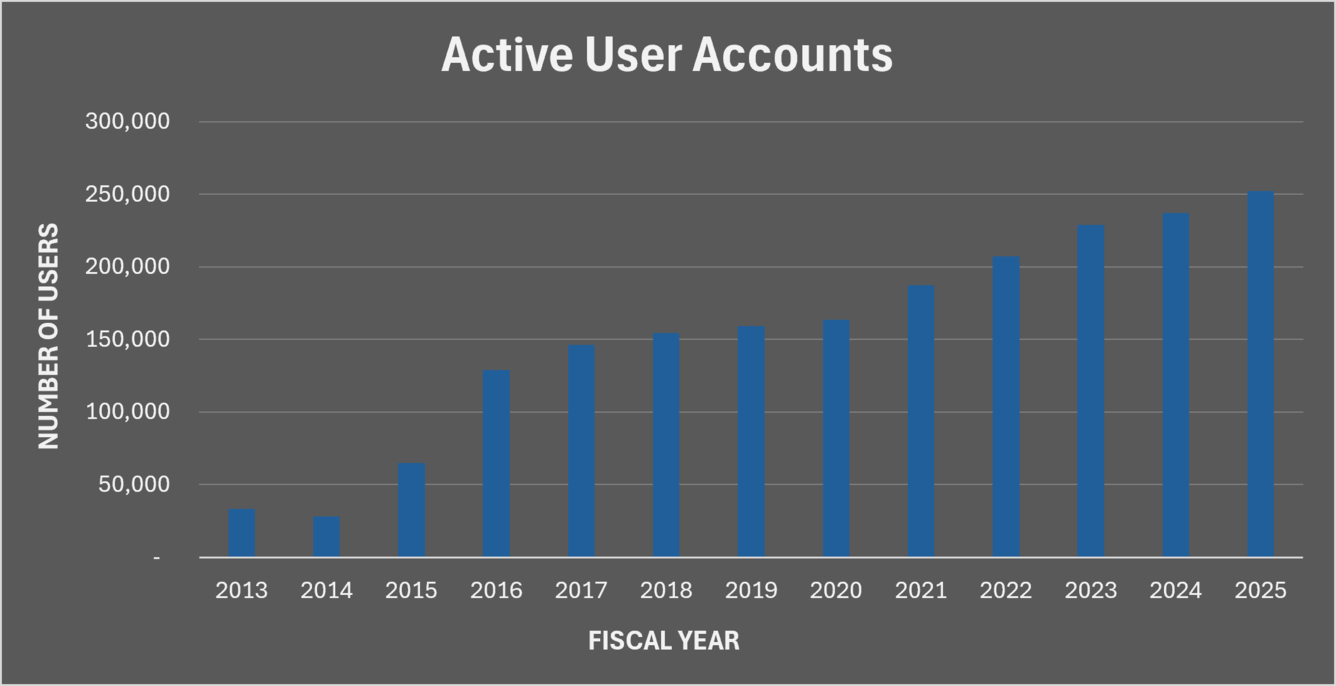
Accessing Landsat data
The graph below displays the number of active user accounts in the USGS EROS Registration Service (ERS) that access Landsat products, since reporting began in 2013. Over the past decade, the number of active users has seen a significant increase, nearing 250,000 active user accounts.
Media
Sources/Usage: Public Domain. View Media Details
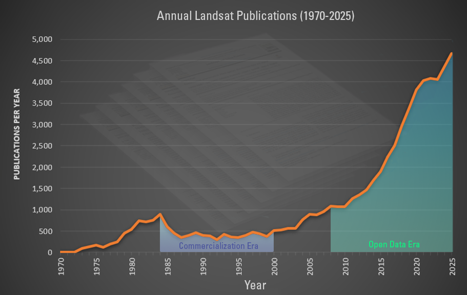
Annual citations for Landsat data
Since 1972, Landsat data have supported land change/land use research – and scientists around the world have been publishing research results and quantifiable information in science journals and Earth observation publications since.
The graphic below displays the number of Landsat-related publications (orange line) starting in 1970. While publications decreased during the Commercialization Era, research rebounded greatly after the USGS open data policy decision in 2008. Citations for all Landsat-related publications can be searched via the world wide web.
Citations for USGS publications specific to Landsat can be viewed in the USGS Publications Warehouse.
Media
Sources/Usage: Public Domain. View Media Details
Historical information
As mentioned above, the amount of data distributed prior to 2008 was much lower compared to the open data era. Prior to 1989, scenes were primarily distributed as hard copy photographic images. Moving from analog to digital data required a shift in how Landsat data were analyzed. Remote sensing laboratories at major universities, such as Purdue’s Laboratory for Applications and Remote Sensing (LARS), established digital remote sensing data processing techniques that allowed image software systems to develop processing and analysis routines. This laid the groundwork for modern processing and analysis routines.
The graph below displays the quantity and type of media of Landsat Level-1 data distributed by the USGS before data became available to download at no charge in 2008. The shift from hard copy photographs of satellite images to physical media began with floppy disks, followed by CD-ROMs, and later DVD’s in the early 2000’s. These physical media were retired in 2008 with the shift to fully online digital data distribution.
Media

Sources/Usage: Public Domain. View Media Details
Today, image viewing and processing software packages continue to evolve, incorporating advanced machine-based learning and artificial intelligence capabilities that allow users to extract even more detailed information about land surfaces from Landsat data.
Related

Landsat in Action - Free & Open Landsat Archive with Barbara Ryan
Barbara Ryan, Director of GEO talks about the distribution of Landsat data, starting in 1972, and ultimately transitioning to the free and open policy of today.

Landsat Data in the Cloud
The Landsat series of Earth-observing satellites has been continuously acquiring land surface imagery since 1972. Over 10 million Landsat scenes are currently available for download. They are also accessible from a cloud environment, in a cloud optimized format that gives you more flexible, customized access.

Landsat in Action — Open Data in Australia with Adam Lewis
Landsat in Action — Open Data in Australia with Adam LewisGeoscience Australia's Acting Chief Scientist Adam Lewis talks about the value of Landsat data, the importance of free and open policy, and how analysis ready data is advancing earth observing science.
Related
Landsat in Action - Free & Open Landsat Archive with Barbara Ryan
Barbara Ryan, Director of GEO talks about the distribution of Landsat data, starting in 1972, and ultimately transitioning to the free and open policy of today.
Landsat Data in the Cloud
The Landsat series of Earth-observing satellites has been continuously acquiring land surface imagery since 1972. Over 10 million Landsat scenes are currently available for download. They are also accessible from a cloud environment, in a cloud optimized format that gives you more flexible, customized access.
The Landsat series of Earth-observing satellites has been continuously acquiring land surface imagery since 1972. Over 10 million Landsat scenes are currently available for download. They are also accessible from a cloud environment, in a cloud optimized format that gives you more flexible, customized access.
Landsat in Action — Open Data in Australia with Adam Lewis
Landsat in Action — Open Data in Australia with Adam LewisGeoscience Australia's Acting Chief Scientist Adam Lewis talks about the value of Landsat data, the importance of free and open policy, and how analysis ready data is advancing earth observing science.