



An environmental DNA (eDNA) sampler discretely placed among the vegetation along a stream on the Flying D Ranch in Montana.
Images
See our science through the images below.
Filter Total Items: 3605

Mostly hidden eDNA sampler along Montana stream
An environmental DNA (eDNA) sampler discretely placed among the vegetation along a stream on the Flying D Ranch in Montana.

I Am A...Malacologist Coloring Page
Welcome to the "The I Am A..." series. This is the sixth video in a series of USGS whiteboard animations that highlight USGS careers.
Welcome to the "The I Am A..." series. This is the sixth video in a series of USGS whiteboard animations that highlight USGS careers.

USGS scientists operate drones with particulate and gas samplers over a prescribed burn in Kansas.
USGS scientists operate drones with particulate and gas samplers over a prescribed burn in Kansas.Joe Adams (USGS National Uncrewed Systems Office) pilots and Keith Grabner (USGS Columbia Environmental Research Center) acts as visual observer as a drone equipped with EPA particulate and gas samplers (right) hovers in the plume of a spring prescribed burn at the Konza Prairie Biological Station, Tallgrass Prairie National Preserve, Kansas.
USGS scientists operate drones with particulate and gas samplers over a prescribed burn in Kansas.
USGS scientists operate drones with particulate and gas samplers over a prescribed burn in Kansas.Joe Adams (USGS National Uncrewed Systems Office) pilots and Keith Grabner (USGS Columbia Environmental Research Center) acts as visual observer as a drone equipped with EPA particulate and gas samplers (right) hovers in the plume of a spring prescribed burn at the Konza Prairie Biological Station, Tallgrass Prairie National Preserve, Kansas.

Blackfoot & Jackson Glaciers in 1914 and 2009
Blackfoot & Jackson Glaciers: 8/1/1914 EC Stebinger, USGS Photographic Library – 9/3/2009 L McKeon, USGS
Since the historic photo was taken, Blackfoot Glacier has retreated and fragmented into two separate glaciers, Blackfoot (foreground) and Jackson (distant) Glaciers.
Blackfoot & Jackson Glaciers: 8/1/1914 EC Stebinger, USGS Photographic Library – 9/3/2009 L McKeon, USGS
Since the historic photo was taken, Blackfoot Glacier has retreated and fragmented into two separate glaciers, Blackfoot (foreground) and Jackson (distant) Glaciers.

Repeat photo of Grinnell Glacier (1910, 2007)
Boulder Glacier in 1910 (Elrod photo, GNP Archives) and in 2007 (Fagre/Pederson photo, USGS). Matching the intersection of the peaks in the background helps the repeat photographer locate the photo point. USGS Public domain
Boulder Glacier in 1910 (Elrod photo, GNP Archives) and in 2007 (Fagre/Pederson photo, USGS). Matching the intersection of the peaks in the background helps the repeat photographer locate the photo point. USGS Public domain

Kintla Glacier in 1901 and 2019
Grinnell, Gem & Salamander Glaciers: 8/9/1910 M Elrod, U of M Library – 9/27/2016 L McKeon, USGS
View the full collection at USGS Photographic Library
Grinnell, Gem & Salamander Glaciers: 8/9/1910 M Elrod, U of M Library – 9/27/2016 L McKeon, USGS
View the full collection at USGS Photographic Library

United States map of modeling results showing the probability of arsenic greater than 5 micrograms per liter. Map of sink and faucet superimposed upon it.
United States map of modeling results showing the probability of arsenic greater than 5 micrograms per liter. Map of sink and faucet superimposed upon it.United States map showing modeling results (red) of the probability of arsenic concentrations greater than 5 micrograms per liter. Map of sink and faucet superimposed upon it.
United States map of modeling results showing the probability of arsenic greater than 5 micrograms per liter. Map of sink and faucet superimposed upon it.
United States map of modeling results showing the probability of arsenic greater than 5 micrograms per liter. Map of sink and faucet superimposed upon it.United States map of modeling results showing the probability of arsenic greater than 5 micrograms per liter. Map of sink and faucet superimposed upon it.
United States map of modeling results showing the probability of arsenic greater than 5 micrograms per liter. Map of sink and faucet superimposed upon it.United States map showing modeling results (red) of the probability of arsenic concentrations greater than 5 micrograms per liter. Map of sink and faucet superimposed upon it.
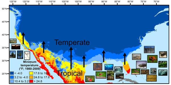
U.S. regions in the tropical-to-temperate transition
U.S. regions in the tropical-to-temperate transitionA map showing North America's tropical-to-temperate transition zone. Red, orange, and yellow depict the more tropical zones, and blues depict the more temperate zones, based on to the coldest recorded temperature for each area between 1980 and 2009.
U.S. regions in the tropical-to-temperate transition
U.S. regions in the tropical-to-temperate transitionA map showing North America's tropical-to-temperate transition zone. Red, orange, and yellow depict the more tropical zones, and blues depict the more temperate zones, based on to the coldest recorded temperature for each area between 1980 and 2009.
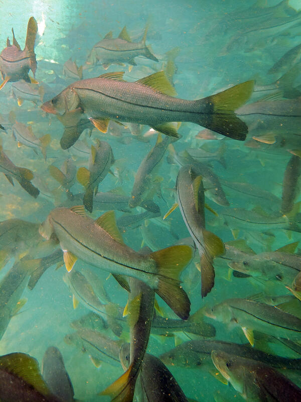
Subtropical snook gather at a warm Florida springhead in winter
Subtropical snook gather at a warm Florida springhead in winterWinter temperature extremes control the distributions of subtropical fishes. Common snook (Centropomus undecimalis), aggregate at a spring in northern Florida during winter. Snook are warm saltwater game fish, common in Florida, that have been moving further northward as extreme cold spells become less frequent and less intense.
Subtropical snook gather at a warm Florida springhead in winter
Subtropical snook gather at a warm Florida springhead in winterWinter temperature extremes control the distributions of subtropical fishes. Common snook (Centropomus undecimalis), aggregate at a spring in northern Florida during winter. Snook are warm saltwater game fish, common in Florida, that have been moving further northward as extreme cold spells become less frequent and less intense.

Agassiz Glacier in 1913 and 2007
Agassiz Glacier: 8/5/1913 WC Alden, USGS Photographic Library - 8/24/2007, D Fagre, USGS
View the full collection at USGS Photographic Library
Agassiz Glacier: 8/5/1913 WC Alden, USGS Photographic Library - 8/24/2007, D Fagre, USGS
View the full collection at USGS Photographic Library

Shepard Glacier
Karen Holzer and Lisa McKeon rephotograph Shepard Glacier from the slope of Pyramid Peak, Glacier National Park. 1998 USGS photo.
Karen Holzer and Lisa McKeon rephotograph Shepard Glacier from the slope of Pyramid Peak, Glacier National Park. 1998 USGS photo.

Chaney Glacier 1911 and 2005
Chaney Glacier: 1911, MR Campbell, USGS Photographic Library – 8/19/2005 Karen Milone, USGS
View the full collection at USGS Photographic Library
Chaney Glacier: 1911, MR Campbell, USGS Photographic Library – 8/19/2005 Karen Milone, USGS
View the full collection at USGS Photographic Library

Boulder Ice Cave Glacier 1932 and 1988
Boulder Glacier Ice Cave: 1932, TJ Hileman, GNP Archives – 1988, J DeSanto, U of M Library
This photo pair inspired the USGS to document glacier and landscape change using oblique photography.
Boulder Glacier Ice Cave: 1932, TJ Hileman, GNP Archives – 1988, J DeSanto, U of M Library
This photo pair inspired the USGS to document glacier and landscape change using oblique photography.

Repeat photo of Harrison Glacier (1913, 2009)
Repeat photo of Harrison Glacier. 8/20/1913 by WC Alden, USGS Photographic Library, 7/30/2009 by Ralph Thornton, USGS.
Repeat photo of Harrison Glacier. 8/20/1913 by WC Alden, USGS Photographic Library, 7/30/2009 by Ralph Thornton, USGS.

Sperry Glacier in about 1930 and 2008
Sperry Glacier: circa 1930, MJ Elrod, U of M Library – 9/17/2008, L McKeon, USGS
Repeating this photo from the same photo point was impossible since the historic photo was shot from the elevated perspective of the glacier’s surface.
Sperry Glacier: circa 1930, MJ Elrod, U of M Library – 9/17/2008, L McKeon, USGS
Repeating this photo from the same photo point was impossible since the historic photo was shot from the elevated perspective of the glacier’s surface.

Shepard Glacier in 1913 and 2005
Shepard Glacier: 9/6/1913, WC Alden, USGS Photo Library – 8/21/2005, B. Reardon, USGS
Shepard Glacier: 9/6/1913, WC Alden, USGS Photo Library – 8/21/2005, B. Reardon, USGS

Repeat photo of Grinnell Glacier (1910, 2016)
Grinnell Glacier in 1910 (Elrod photo, U of M Collection) and 2016 (McKeon photo, USGS). Retreat resulted in glacier fragmentation, so the 2016 scene shows both Grinnell Glacier, hugging the base of the cliff, and The Salamander Glacier, perched above, along the right edge of the photograph.
Grinnell Glacier in 1910 (Elrod photo, U of M Collection) and 2016 (McKeon photo, USGS). Retreat resulted in glacier fragmentation, so the 2016 scene shows both Grinnell Glacier, hugging the base of the cliff, and The Salamander Glacier, perched above, along the right edge of the photograph.

Grinnell Glacier from 1938 and 2019
Grinnell and The Salamander Glaciers from the summit of Mt. Gould: 1938, TJ Hileman, GNP Archives – 9/4/2019, L McKeon, USGS
Upper Grinnell Lake has formed as the glacier has retreated. The change in height of Grinnell Glacier along the cliff face hints at volume loss during this timespan.
Grinnell and The Salamander Glaciers from the summit of Mt. Gould: 1938, TJ Hileman, GNP Archives – 9/4/2019, L McKeon, USGS
Upper Grinnell Lake has formed as the glacier has retreated. The change in height of Grinnell Glacier along the cliff face hints at volume loss during this timespan.

Swiftcurrent Glacier in 1910 and 2016
Swiftcurrent Glacier: circa 1910, M. Elod, GNP Archives - 9/27/2016, L McKeon, USGS
During the timespan between these photos, it is evident that Swiftcurrent Glacier has retreated and wildfire has consumed a patch of trees at the base of Swiftcurrent Mountain, the broad, beige slope in the background.
Swiftcurrent Glacier: circa 1910, M. Elod, GNP Archives - 9/27/2016, L McKeon, USGS
During the timespan between these photos, it is evident that Swiftcurrent Glacier has retreated and wildfire has consumed a patch of trees at the base of Swiftcurrent Mountain, the broad, beige slope in the background.

Logan and Red Eagle Glaciers in 1914 and 2009
Logan and Red Eagle Glaciers: Aug. 1914, EC Stebinger, USGS Photo Library – 9/2/2009, L McKeon, USGS
These glaciers were once a continuous glacier, but became separate glaciers as retreat progressed.
Logan and Red Eagle Glaciers: Aug. 1914, EC Stebinger, USGS Photo Library – 9/2/2009, L McKeon, USGS
These glaciers were once a continuous glacier, but became separate glaciers as retreat progressed.

Jackson Glacier in 1912 and 2009
Jackson Glacier: 1912, MJ Elrod, U of M Library – 9/3/2009, L McKeon, USGS
Trees and vegetation continue to establish themselves at the base of Jackson Glacier as the glacier retreats.
Jackson Glacier: 1912, MJ Elrod, U of M Library – 9/3/2009, L McKeon, USGS
Trees and vegetation continue to establish themselves at the base of Jackson Glacier as the glacier retreats.