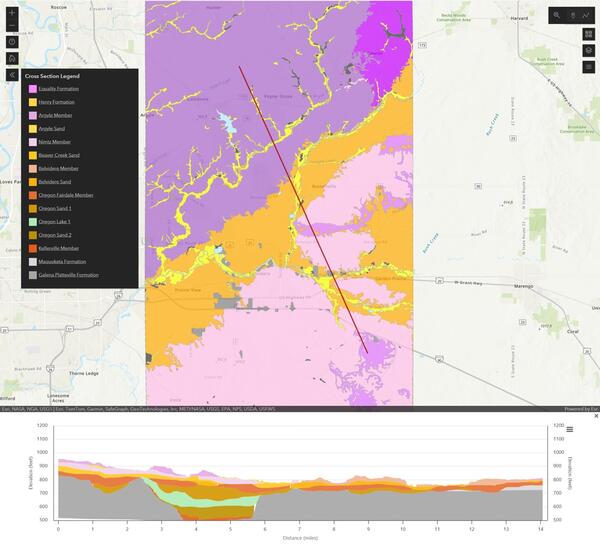
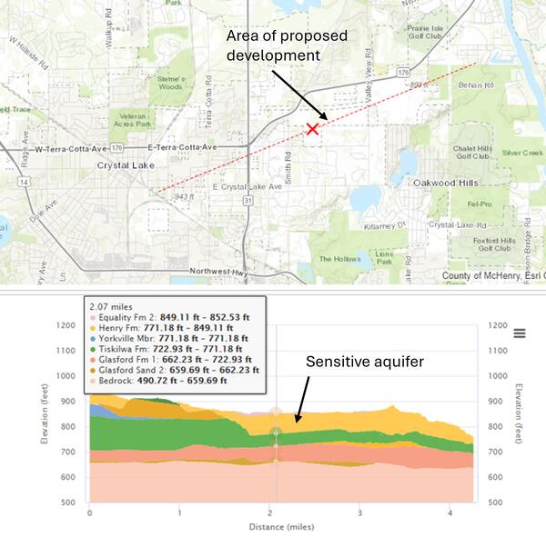
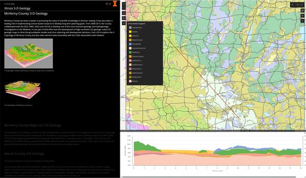
U.S. flag

An official website of the United States government

Images

Energy and Minerals Mission Area images.

Filter Total Items: 523
Screen clipped image showing the surficial geology of Boone County above and a subsurface diagram below using different color
3D view of surficial geology and subsurface cross section within Boone County, IL

This screen clipped image was generated with the Illinois State Geological Survey's 3D viewer. This map shows the surficial geology of Boon County, Illinois above a generated cross section along the red diagonal indicator line.

Crossword puzzle about the critical mineral manganese.
USGS MRP Critical Mineral Crossword Puzzle: Manganese

Critical Mineral Crossword Puzzle: Manganese

Manganese is listed as a "critical mineral". Learn about where we get manganese and how we use it by solving the crossword puzzle clues!

More information:

Coloring sheet featuring cassiterite and the critical mineral tin.
USGS MRP Coloring Page Cassiterite

USGS Mineral Resources Program coloring page for cassiterite and the critical mineral tin.

The mineral cassiterite, chemical formula SnO2, is the most important mineral source for the critical mineral tin. Fun facts: tin is one of the earliest metals used by humans! The chemical symbol for tin, Sn, comes from its Latin name, stannum.

Coloring sheet for galena and the critical mineral lead.
USGS MRP Coloring Page Galena

USGS Mineral Resources Program coloring page for the mineral galena and the critical mineral lead.

Coloring page for the critical mineral barite.
USGS MRP Coloring Page Barite

USGS Mineral Resources Program coloring page for the critical mineral barite.

Barite, chemical formula BaSO4, is a critical mineral. Fun fact: barite is one of the heaviest minerals that isn't a metal.

USGS Mineral Resources Program coloring page for the critical mineral barite.

Barite, chemical formula BaSO4, is a critical mineral. Fun fact: barite is one of the heaviest minerals that isn't a metal.

Crossword puzzle for the critical mineral rhenium.
USGS MRP Critical Mineral Crossword Puzzle: Rhenium

Critical Mineral Crossword Puzzle: Rhenium.

Rhenium is listed as "critical mineral". Learn about where we get rhenium and how we use it by solving the crossword puzzle clues!


More information

Map of the state of Illinois including county boundaries showing distribution of glacial deposits in different colors.
Glacial Terrain of Illinois

This map shows the generalized glaciated terrain of the state of Illinois. For more information, visit the Illinois State Geological Survey website. 

Street map of area within McHenry County IL above subsurface cross section showing rock units in different colors
Cross section within McHenry County, IL created with 3D viewer along area of proposed development

This image shows a street map within McHenry County, Illinois (above). The red line indicates the location of the geologic cross section (below). The red line shows an area of proposed development and the cross section indicates the existence of a sensitive aquifer along that locator line. 

This image shows a street map within McHenry County, Illinois (above). The red line indicates the location of the geologic cross section (below). The red line shows an area of proposed development and the cross section indicates the existence of a sensitive aquifer along that locator line. 

Infographic listing all 60 critical minerals on List
2025 List of Critical Minerals

2025 List of Critical Minerals

The 2025 List of Critical Minerals includes 60 critical minerals. 50 of these were also included on the 2022 List of Critical Minerals, and 10 are new. There are 15 rare earth elements included on the List. 

2025 List of Critical Minerals

The 2025 List of Critical Minerals includes 60 critical minerals. 50 of these were also included on the 2022 List of Critical Minerals, and 10 are new. There are 15 rare earth elements included on the List. 

Photograph of six people on a stage with a blue background and high banner reading "Innovation Stage."
BSGMC 2025 Winners Stage

This is an image of the top two winners from the competition holding their awards along with contest sponsors. 

This is an image of the top two winners from the competition holding their awards along with contest sponsors. 

Photograph of a geologic map poster.
Franklin Lake Second Place BSGMC 2025.jpg

This picture illustrates a BSGMC participant student poster presented at GSA. 

Terry Lee from the University of Nevada, Reno, 1:24,000-Scale Geologic Map of the Western Half of the Franklin Lake NW 7.5-Minute Quadrangle, Ruby Mountains-East Humboldt Range Metamorphic Core Complex, Northeast Nevada.

Photograph of a geologic map poster.
Salt Structures Third Place BSGMC 2025

This picture illustrates a BSGMC participant student poster presented at GSA. 

David Canova, University of Barcelona, Salt structures in the Eastern External Betics fold and thrust belt, SE Iberia—Geologic maps, cross sections, and palinspastic reconstructions. 

This picture illustrates a BSGMC participant student poster presented at GSA. 

David Canova, University of Barcelona, Salt structures in the Eastern External Betics fold and thrust belt, SE Iberia—Geologic maps, cross sections, and palinspastic reconstructions. 

Photograph of a geologic map poster.
Survey Peak First Place BSGMC 2025

This picture illustrates a BSGMC participant student poster presented at GSA. 

Terri Zach, University of Kentucky, Geology of the Survey Peak 7.5' Quadrangle, Wyoming: Using Detailed Mapping to Reconstruct the Paleo-Topography of the Northern Teton Range and Implications for the Paleo-Teton Collapse Hypothesis.

Large green rectangular sign reading "Best Student Geologic Map Competition"
BSGMC Sign GSA 2025
BSGMC Sign GSA 2025
BSGMC Sign GSA 2025

This is an image of the sign that was placed at the 2025 GSA annual meeting to designate the USGS NCGMP-hosted BSGMC. 

This is an image of the sign that was placed at the 2025 GSA annual meeting to designate the USGS NCGMP-hosted BSGMC. 

White and brown carboard boxes stacked on top of each other.
Physical data ready for archive

Alaska Science Center Data Management staff organize, scan, and digitally archive physical data. Once published as part of a data release, the physical data are organized and placed into banker boxes, labeled with pertinent information, such as the data release DOI, and moved to a secure location.

Alaska Science Center Data Management staff organize, scan, and digitally archive physical data. Once published as part of a data release, the physical data are organized and placed into banker boxes, labeled with pertinent information, such as the data release DOI, and moved to a secure location.

Isolated aluminum specimen from the USGS mineral collection.
Aluminum
Aluminum
Aluminum

Isolated aluminum specimen from the USGS mineral collection. High-definition image showing metallic texture and matte surface.

Isolated aluminum specimen from the USGS mineral collection. High-definition image showing metallic texture and matte surface.

Isolated barite specimen from the USGS mineral collection.
Barite
Barite
Barite

Isolated barite specimen from the USGS mineral collection. High-definition image showing tabular crystal structure and pale color.

Isolated barite specimen from the USGS mineral collection. High-definition image showing tabular crystal structure and pale color.

High-definition image of a barite specimen showing layered structure and subtle color variations.
Barite Crystal 2
Barite Crystal 2
Barite Crystal 2

High-definition image of a barite specimen showing layered structure and subtle color variations.

High-definition image of a barite specimen showing layered structure and subtle color variations.

Was this page helpful?