Northern Alaska and potential gas hydrate occurences
Northern Alaska and potential gas hydrate occurences


Official websites use .gov
A .gov website belongs to an official government organization in the United States.

Secure .gov websites use HTTPS
A lock () or https:// means you’ve safely connected to the .gov website. Share sensitive information only on official, secure websites.

Images from the Geology, Energy and Minerals Mission Area


Scientists have found that wind turbines are causing fatalities of certain species of migratory insect-eating bats, although a March 2011 study in Science suggests that solutions to reduce the impacts of wind turbines on bats may be possible.
Scientists have found that wind turbines are causing fatalities of certain species of migratory insect-eating bats, although a March 2011 study in Science suggests that solutions to reduce the impacts of wind turbines on bats may be possible.

A drill rig at the Mount Elbert test site in Alaska's North Slope, just west of Prudhoe Bay. USGS joined BP Exploration (Alaska) and the U.S. Department of Energy to drill a test well to study natural gas production from gas hydrate deposits. Read more about the Mt.
A drill rig at the Mount Elbert test site in Alaska's North Slope, just west of Prudhoe Bay. USGS joined BP Exploration (Alaska) and the U.S. Department of Energy to drill a test well to study natural gas production from gas hydrate deposits. Read more about the Mt.
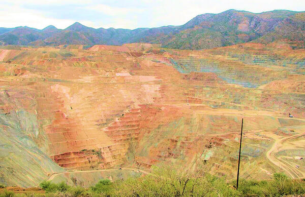
USGS photo of Ray Copper Mine in Pinal County, Arizona. Taken by Mark Coker on September 1, 2007. Revised for brightness and contrast for use as a webpage Carousel image.
USGS photo of Ray Copper Mine in Pinal County, Arizona. Taken by Mark Coker on September 1, 2007. Revised for brightness and contrast for use as a webpage Carousel image.

Trans-Alaska Pipeline, northern Brooks Range, Alaska. Rocks in the background produce oil on the North Slope.
Trans-Alaska Pipeline, northern Brooks Range, Alaska. Rocks in the background produce oil on the North Slope.

Bed sediment sampling, Suwanee Creek, Gwinnett Co, Georgia
Bed sediment sampling, Suwanee Creek, Gwinnett Co, Georgia

Mount Elbert gas hydrate stratigraphic test well on the North Slope of Alaska.
Mount Elbert gas hydrate stratigraphic test well on the North Slope of Alaska.

This image shows gas hydrates (the white material) in marine sediments from a test well drilled in the Indian Ocean in 2006 during the Indian National Gas Hydrate Program (NGHP) Expedition 01.
This image shows gas hydrates (the white material) in marine sediments from a test well drilled in the Indian Ocean in 2006 during the Indian National Gas Hydrate Program (NGHP) Expedition 01.

This image shows gas hydrates (the white material) in marine sediments from a test well drilled in the Indian Ocean in 2006 during the Indian National Gas Hydrate Program (NGHP) Expedition 01.
This image shows gas hydrates (the white material) in marine sediments from a test well drilled in the Indian Ocean in 2006 during the Indian National Gas Hydrate Program (NGHP) Expedition 01.

This image shows gas hydrates (the white material) in marine sediments from a test well drilled in the Indian Ocean in 2006 during the Indian National Gas Hydrate Program (NGHP) Expedition 01.
This image shows gas hydrates (the white material) in marine sediments from a test well drilled in the Indian Ocean in 2006 during the Indian National Gas Hydrate Program (NGHP) Expedition 01.

This image shows gas hydrates (the white material) in marine sediments from a test well drilled in the Indian Ocean in 2006 during the Indian National Gas Hydrate Program (NGHP) Expedition 01.
This image shows gas hydrates (the white material) in marine sediments from a test well drilled in the Indian Ocean in 2006 during the Indian National Gas Hydrate Program (NGHP) Expedition 01.

These rare-earth oxides are used as tracers to determine which parts of a watershed are eroding. Clockwise from top center: praseodymium, cerium, lanthanum, neodymium, samarium, and gadolinium. Image Number D1115-1. Photo by Peggy Greb, USDA-ARS.
These rare-earth oxides are used as tracers to determine which parts of a watershed are eroding. Clockwise from top center: praseodymium, cerium, lanthanum, neodymium, samarium, and gadolinium. Image Number D1115-1. Photo by Peggy Greb, USDA-ARS.

An open-pit mine for volcanic-hosted copper deposits from the Bolnisi District of the Republic of Georgia.
An open-pit mine for volcanic-hosted copper deposits from the Bolnisi District of the Republic of Georgia.

An open-pit mine for volcanic-hosted copper deposits from the Bolnisi District of the Republic of Georgia. A controlled blast as part of the mining process can be seen.
An open-pit mine for volcanic-hosted copper deposits from the Bolnisi District of the Republic of Georgia. A controlled blast as part of the mining process can be seen.

USGS scientist Bernard Hubbard conducting spectral measurements of soils and cover crops to ground truth satellite imagery being used to map soil erosion and runoff potential into the Chesapeake Bay watershed.
USGS scientist Bernard Hubbard conducting spectral measurements of soils and cover crops to ground truth satellite imagery being used to map soil erosion and runoff potential into the Chesapeake Bay watershed.

USGS scientist measuring pH, Specific Conductance and dissolved oxygen in a remediation ditch constructed with local volcanic rock possessing some acid neutralizing capacity.
Brown's Gulch is below the Brooklyn Mine, a few miles north of Siverton, Colorado, in the Mineral Creek basin.
USGS scientist measuring pH, Specific Conductance and dissolved oxygen in a remediation ditch constructed with local volcanic rock possessing some acid neutralizing capacity.
Brown's Gulch is below the Brooklyn Mine, a few miles north of Siverton, Colorado, in the Mineral Creek basin.

A drill rig at the Mallik test site in Canada's Mckenzie Delta. USGS joined the Geological Survey of Canada, JAPEX, and the Japanese National Oil Company to drill test wells for natural gas production from gas hydrate deposits.
A drill rig at the Mallik test site in Canada's Mckenzie Delta. USGS joined the Geological Survey of Canada, JAPEX, and the Japanese National Oil Company to drill test wells for natural gas production from gas hydrate deposits.

This image shows an inukshuk, a stone cairn used by indigenous peoples in northern latitudes, particularly in places like northern Canada.
This image shows an inukshuk, a stone cairn used by indigenous peoples in northern latitudes, particularly in places like northern Canada.

During Ocean Drilling Program Leg 204, nine sites were cored and wireline logged on the Oregon continental margin to determine the distribution and concentration of gas hydrates in an accretionary ridge setting, investigate the mechanisms that transport methane and other gases into the gas hydrate stability zone, and obtain constraints on physical properties of
During Ocean Drilling Program Leg 204, nine sites were cored and wireline logged on the Oregon continental margin to determine the distribution and concentration of gas hydrates in an accretionary ridge setting, investigate the mechanisms that transport methane and other gases into the gas hydrate stability zone, and obtain constraints on physical properties of

View from a distance of the power plant cooling tower on the edge of Lake Michigan.
View from a distance of the power plant cooling tower on the edge of Lake Michigan.

Erika Lentz examines Pennsylvanian coal samples in West Virginia.
Erika Lentz examines Pennsylvanian coal samples in West Virginia.