Adjuntas, Puerto Rico Landslide Monitoring Station
Adjuntas, Puerto Rico Landslide Monitoring StationCompleted landslide monitoring station at Adjuntas, Puerto Rico among the palms.

Official websites use .gov
A .gov website belongs to an official government organization in the United States.
Secure .gov websites use HTTPS
A lock () or https:// means you’ve safely connected to the .gov website. Share sensitive information only on official, secure websites.
Images related to natural hazards.

Completed landslide monitoring station at Adjuntas, Puerto Rico among the palms.
Completed landslide monitoring station at Adjuntas, Puerto Rico among the palms.
Completed landslide monitoring station at Adjuntas, Puerto Rico among the palms. One of the sites in the Puerto Rico Landslide Monitoring Network.
Completed landslide monitoring station at Adjuntas, Puerto Rico among the palms. One of the sites in the Puerto Rico Landslide Monitoring Network.

Kelli Baxstrom wires sensors to a datalogger after sensors are installed underground at the Adjuntas, Puerto Rico, landslide monitoring site, part of the Puerto Rico Landslide Monitoring Network.
Kelli Baxstrom wires sensors to a datalogger after sensors are installed underground at the Adjuntas, Puerto Rico, landslide monitoring site, part of the Puerto Rico Landslide Monitoring Network.

Triptych of images showing wildfire, roadside flooding, and the Big Sur coastline in California.
Triptych of images showing wildfire, roadside flooding, and the Big Sur coastline in California.

The wee strand is a beach along the head of of Loch Indaal, Scotland. Loch Indaal is an ocean bay on Islay, the southernmost island of the Hebrides, off the west coast of Scotland.
The wee strand is a beach along the head of of Loch Indaal, Scotland. Loch Indaal is an ocean bay on Islay, the southernmost island of the Hebrides, off the west coast of Scotland.

This is a coloring page for the USGS I Am A... career series depicting a Volcanologist.
This is a coloring page for the USGS I Am A... career series depicting a Volcanologist.

Vehicles drive on interstate I-70 in Glenwood Canyon, Colorado. In the summer of 2021, travelers in Colorado's Glenwood Canyon were safely evacuated before massive debris flows buried highways and destroyed bridges, thanks to a debris flow warning system developed in part by the U.S. Geological Survey.
Vehicles drive on interstate I-70 in Glenwood Canyon, Colorado. In the summer of 2021, travelers in Colorado's Glenwood Canyon were safely evacuated before massive debris flows buried highways and destroyed bridges, thanks to a debris flow warning system developed in part by the U.S. Geological Survey.

USGS scientist cuts open core taken in the field to sample soils and vegetation for chemical analysis.
USGS scientist cuts open core taken in the field to sample soils and vegetation for chemical analysis.

Locations of Puerto Rico’s North Coast Aqueduct interconnections and water transferred, in million gallons per day (Mgal/d) in 2015.
Locations of Puerto Rico’s North Coast Aqueduct interconnections and water transferred, in million gallons per day (Mgal/d) in 2015.

Scientists assess post wildfire debris flow following the 2020 Grizzly Creek fire.
Scientists assess post wildfire debris flow following the 2020 Grizzly Creek fire.

Debris flow in Glenwood Canyon during the summer of 2021. This event followed the 2020 Grizzly Creek Fire in Glenwood Canyon, Colorado.
Debris flow in Glenwood Canyon during the summer of 2021. This event followed the 2020 Grizzly Creek Fire in Glenwood Canyon, Colorado.

Interstate 70 in Glenwood Canyon, Colorado. In the summer of 2021, travelers in Colorado's Glenwood Canyon were safely evacuated before massive debris flows buried highways and destroyed bridges, thanks to a debris flow warning system developed in part by the U.S. Geological Survey.
Interstate 70 in Glenwood Canyon, Colorado. In the summer of 2021, travelers in Colorado's Glenwood Canyon were safely evacuated before massive debris flows buried highways and destroyed bridges, thanks to a debris flow warning system developed in part by the U.S. Geological Survey.

USGS scientist assesses debris flow in Glenwood Canyon, Colorado. This post-wildfire debris flow follows the 2020 Grizzly Creek Fire.
USGS scientist assesses debris flow in Glenwood Canyon, Colorado. This post-wildfire debris flow follows the 2020 Grizzly Creek Fire.

Denis Staley stands on a rock formation in Alaska. He is a landslide hazard researcher based out of the Alaska Volcano Observatory.
Denis Staley stands on a rock formation in Alaska. He is a landslide hazard researcher based out of the Alaska Volcano Observatory.

Kelli Baxstrom excavates a pit for sensor installation at a monitoring site in Maricao, Puerto Rico.
Kelli Baxstrom excavates a pit for sensor installation at a monitoring site in Maricao, Puerto Rico.

USGS Geologists R. Sickler, J. Willard, and B. Philibosian observe as an excavator digs a pit used to investigate sediments uplifted by active tectonic activity in the San Joaquin – Sacramento Delta, California, November 29, 2021.
USGS Geologists R. Sickler, J. Willard, and B. Philibosian observe as an excavator digs a pit used to investigate sediments uplifted by active tectonic activity in the San Joaquin – Sacramento Delta, California, November 29, 2021.
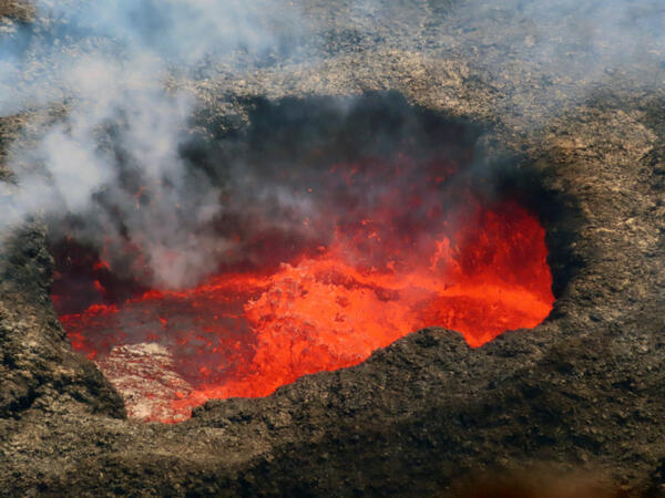
A telephoto view of the west vent along the western wall of Halema‘uma‘u crater at the summit of Kīlauea. On November 9, spatter bursts in the west vent cone triggered sloshing on the surface of the ponded lava. Spatter was thrown about 6–9 m (20–30 ft) above the pond surface and occasionally deposited onto the rim of the cone.
A telephoto view of the west vent along the western wall of Halema‘uma‘u crater at the summit of Kīlauea. On November 9, spatter bursts in the west vent cone triggered sloshing on the surface of the ponded lava. Spatter was thrown about 6–9 m (20–30 ft) above the pond surface and occasionally deposited onto the rim of the cone.

The USGS Gas Hydrates Project develops and tests new tools to address the critical knowledge gaps identified as scientists analyze hydrate-bearing pressure cores recovered during field programs. HyPrCal Laboratory analysis using Pressure Core Characterization Tools.
The USGS Gas Hydrates Project develops and tests new tools to address the critical knowledge gaps identified as scientists analyze hydrate-bearing pressure cores recovered during field programs. HyPrCal Laboratory analysis using Pressure Core Characterization Tools.
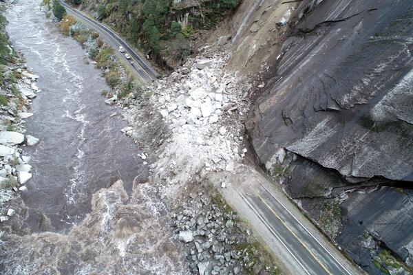
Rockslide on California State Route 70 in the Feather River Canyon, Butte/Plumas county line, northern California. This slide was triggered on October 24, 2021 by a Category 5 atmospheric river, which released more than ten inches of rain in the area over a 48-hour period. Approximately seven thousand cubic yards of rock and debris buried and closed the highway.
Rockslide on California State Route 70 in the Feather River Canyon, Butte/Plumas county line, northern California. This slide was triggered on October 24, 2021 by a Category 5 atmospheric river, which released more than ten inches of rain in the area over a 48-hour period. Approximately seven thousand cubic yards of rock and debris buried and closed the highway.

The USGS “Chambers” site is located in the Plumas National Forest in northern California. The site consists of instrumentation monitoring the hillslope in the lower part of the image. The hillslope exhibits moderate soil burn severity and hosts sandy soils derived from granitic bedrock.
The USGS “Chambers” site is located in the Plumas National Forest in northern California. The site consists of instrumentation monitoring the hillslope in the lower part of the image. The hillslope exhibits moderate soil burn severity and hosts sandy soils derived from granitic bedrock.

The USGS “Chips” site is located in the Plumas National Forest in northern California. The site consists of instrumentation monitoring the hillslope in the lower part of the image. The hillslope exhibits moderate soil burn severity and hosts silty soils derived from metamorphic bedrock.
The USGS “Chips” site is located in the Plumas National Forest in northern California. The site consists of instrumentation monitoring the hillslope in the lower part of the image. The hillslope exhibits moderate soil burn severity and hosts silty soils derived from metamorphic bedrock.