
Lava fountains, occasionally surging to heights of 45-55 m (150-180 ft), erupted south and north of Keanakāko‘i Crater (top and middle fissures, respectively) and on the floor of Kīlauea Caldera (foreground fissure) in a spectacular summit eruption on July 19, 1974.
Images
Images related to natural hazards.
Filter Total Items: 7275

Kīlauea's July 1974 summit eruption
Lava fountains, occasionally surging to heights of 45-55 m (150-180 ft), erupted south and north of Keanakāko‘i Crater (top and middle fissures, respectively) and on the floor of Kīlauea Caldera (foreground fissure) in a spectacular summit eruption on July 19, 1974.
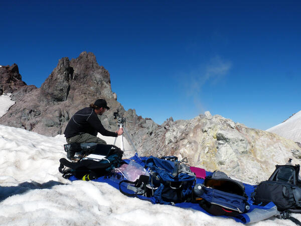
USGS geologist uses a UV spectrometer to detect gases from a fumarole
USGS geologist uses a UV spectrometer to detect gases from a fumaroleUSGS geologist uses a UV spectrometer to detect gases from fumarole at Crater Rock, Mount Hood.
USGS geologist uses a UV spectrometer to detect gases from a fumarole
USGS geologist uses a UV spectrometer to detect gases from a fumaroleUSGS geologist uses a UV spectrometer to detect gases from fumarole at Crater Rock, Mount Hood.

Exploring Mount Rainier: living near a volcano provides an opportu...
Exploring Mount Rainier: living near a volcano provides an opportu...Exploring Mount Rainier: living near a volcano provides an opportunity for field-based learning.
Exploring Mount Rainier: living near a volcano provides an opportu...
Exploring Mount Rainier: living near a volcano provides an opportu...Exploring Mount Rainier: living near a volcano provides an opportunity for field-based learning.

Surface flows on pali and coastal plain; small lava lake in Pu‘u ‘Ō‘ō
Surface flows on pali and coastal plain; small lava lake in Pu‘u ‘Ō‘ōSurface flows remain active on the coastal plain, but have retreated inland compared to their position last week. The active front is now about 1.3 km (0.8 miles) from the ocean.

In addition to active flows on the coastal plain, lava flows were a...
In addition to active flows on the coastal plain, lava flows were a...In addition to the active flows on the coastal plain, lava flows were also active on the pali and at the base of the pali. Pu‘u ‘Ō‘ō and the Halema‘uma‘u plume are visible near the top of the image.

Pu‘u ‘Ō‘ō — Lava Lake
The lava lake on the northeastern edge of the Pu‘u ‘Ō‘ō crater floor is about 30 m (100 ft) across. It's level rises and falls with changes in pressure in the magma storage body beneath Pu‘u ‘Ō‘ō. Today, the lava lake was at a relatively low level, compared to its condition over the last few months.
The lava lake on the northeastern edge of the Pu‘u ‘Ō‘ō crater floor is about 30 m (100 ft) across. It's level rises and falls with changes in pressure in the magma storage body beneath Pu‘u ‘Ō‘ō. Today, the lava lake was at a relatively low level, compared to its condition over the last few months.

Several openings on the floor of the Pu‘u ‘Ō‘ō
Several openings on the floor of the Pu‘u ‘Ō‘ō crater and along the Peace Day flow tube system continue to degas profusely. The only visible lava, however, is the small lava lake confined to a pit on the northeastern side of the crater floor. The lava lake has been present for the last several months.
Several openings on the floor of the Pu‘u ‘Ō‘ō crater and along the Peace Day flow tube system continue to degas profusely. The only visible lava, however, is the small lava lake confined to a pit on the northeastern side of the crater floor. The lava lake has been present for the last several months.

Water depth measurements at Spirit Lake, Mount St. Helens, using ac...
Water depth measurements at Spirit Lake, Mount St. Helens, using ac...Back at the USGS Cascades Volcano Observatory office, these data are merged with airborne LiDAR data to calculate lake volume.
Water depth measurements at Spirit Lake, Mount St. Helens, using ac...
Water depth measurements at Spirit Lake, Mount St. Helens, using ac...Back at the USGS Cascades Volcano Observatory office, these data are merged with airborne LiDAR data to calculate lake volume.

Kīlauea's summit and rift zones are well connected
Kīlauea's summit and rift zones are well connectedA view of the lava lake within the Halema‘uma‘u Overlook vent on an unusually clear day (May 16, 2012) with the Jaggar Museum and the HVO building in the distance.
Kīlauea's summit and rift zones are well connected
Kīlauea's summit and rift zones are well connectedA view of the lava lake within the Halema‘uma‘u Overlook vent on an unusually clear day (May 16, 2012) with the Jaggar Museum and the HVO building in the distance.

Macroalgae, seagrass, and litter oh my!
Macroalgae, seagrass, and litter in West Falmouth Harbor, MA
Macroalgae, seagrass, and litter in West Falmouth Harbor, MA

A narrow channelized flow cascades down the steep lower portion of ...
A narrow channelized flow cascades down the steep lower portion of ...A narrow channelized flow cascades down the steep lower portion of the pali in Royal Gardens subdivision. This flow was close to the former location of Paradise St.

Burned Trees after wildfire in Gila National Forest
Burned Trees after wildfire in Gila National ForestBurned trees along the trail into Hummingbird Saddle, Gila National Forest, New Mexico, where USGS scientists installed a rain gage.
Burned Trees after wildfire in Gila National Forest
Burned Trees after wildfire in Gila National ForestBurned trees along the trail into Hummingbird Saddle, Gila National Forest, New Mexico, where USGS scientists installed a rain gage.

USGS rain gage installation
USGS scientist finishes the installation of a rain gage at Hummingbird Saddle, Gila National Forest, New Mexico.
USGS scientist finishes the installation of a rain gage at Hummingbird Saddle, Gila National Forest, New Mexico.

Helicopter View of Gila Wilderness Area
Aerial view of the Gila Wilderness Area on the approach to Mogollon Baldy Lookout, where USGS scientists installed a rain gage to provide advance flood warning, Gila National Forest, New Mexico.
Aerial view of the Gila Wilderness Area on the approach to Mogollon Baldy Lookout, where USGS scientists installed a rain gage to provide advance flood warning, Gila National Forest, New Mexico.

Widespread flows on coastal plain and pali, but little advancement
Widespread flows on coastal plain and pali, but little advancementLava flows remain active on the pali and coastal plain, but the flow front has made no significant progress towards the ocean over the past week. This image is a composite of a thermal image and a normal photograph, with active breakouts shown by yellow and white areas, and recent, but inactive, flows shown in red and purple.

Tarawera's 1886 eruption is one to remember
View from near the top of Mount Tarawera looking northeast along part of the string of explosion craters that split the volcano on June 10, 1886. Mount Edgecumbe stands in the distance.
View from near the top of Mount Tarawera looking northeast along part of the string of explosion craters that split the volcano on June 10, 1886. Mount Edgecumbe stands in the distance.

View of Pu‘u ‘Ō‘ō, looking SW. In the foreground, an active, spatt...
View of Pu‘u ‘Ō‘ō, looking SW. In the foreground, an active, spatt...View of Pu‘u ‘Ō‘ō crater, looking southwest. In the foreground, an active, spattering lava pond is contained within a collapse pit near the east rim of the crater. Two additional vents, both emitting fume, can be seen behind the fume from the lava pond.

Lava flows on the pali and coastal plain, and a lava pond in Pu‘u ‘Ō‘ō
Lava flows on the pali and coastal plain, and a lava pond in Pu‘u ‘Ō‘ōLava flows remain active on the pali and coastal plain, and continue to slowly migrate towards the ocean. This thermal-visual composite shows the distribution of active flows, which are extensive and consist of several lobes. The active flow front today was 1.1 km (0.7 miles) from the water.

lava pond in the eastern portion of Pu‘u ‘Ō‘ō.
A close-up of the lava pond in the eastern portion of Pu‘u ‘Ō‘ō crater. The lava pond is about 30 meters (100 ft) in diameter. The dark lava flows at the bottom of the photo are crater overflows that swept down the east flank of Pu‘u ‘Ō‘ō in September 2011.
A close-up of the lava pond in the eastern portion of Pu‘u ‘Ō‘ō crater. The lava pond is about 30 meters (100 ft) in diameter. The dark lava flows at the bottom of the photo are crater overflows that swept down the east flank of Pu‘u ‘Ō‘ō in September 2011.

Image of ongoing lava flow activity
This false-color satellite image shows the ongoing lava flow activity on the east rift zone of Kīlauea volcano along with nearby cities and towns on the east side of the Big Island. The image was acquired at 10:28 am on June 12 by the Advanced Land Imager sensor aboard the NASA Earth Observing 1 satellite.
This false-color satellite image shows the ongoing lava flow activity on the east rift zone of Kīlauea volcano along with nearby cities and towns on the east side of the Big Island. The image was acquired at 10:28 am on June 12 by the Advanced Land Imager sensor aboard the NASA Earth Observing 1 satellite.

USGS 1972 Flood Marker in Keystone, SD
Mark Anderson, Director of the USGS South Dakota Water Science Center, dedicated a flood marker at the Post Office in Keystone, SD, in June 2012 to commenorate the 40th anniversary of the devastating 1972 flood in the Black Hills of South Dakota.
Mark Anderson, Director of the USGS South Dakota Water Science Center, dedicated a flood marker at the Post Office in Keystone, SD, in June 2012 to commenorate the 40th anniversary of the devastating 1972 flood in the Black Hills of South Dakota.