
Fire Island, New York shoreline
Images
Images related to natural hazards.
Filter Total Items: 7275

Fire Island, New York shoreline

Ocean side homes on Fire Island, New York
Ocean side homes on Fire Island, New York
Ocean side homes on Fire Island, New York

2009 Atlanta Flood and Stream Gage Repairs
Jon Evans (GaWSC) making a bridge board streamflow measurement at 02207335 Yellow River at Gees Mill Road, near Milstead, GA.
Jon Evans (GaWSC) making a bridge board streamflow measurement at 02207335 Yellow River at Gees Mill Road, near Milstead, GA.

2009 Atlanta Flood and Stream Gage Repairs
Paul Ankcorn (GaWSC) inspecting the streamgage 02207120 Yellow River at GA 124, near Lithonia, GA.
Paul Ankcorn (GaWSC) inspecting the streamgage 02207120 Yellow River at GA 124, near Lithonia, GA.

Boulder Geomagnetic Observatory
Jeff Fox using a theodolite at the Boulder geomagnetic observatory.
Jeff Fox using a theodolite at the Boulder geomagnetic observatory.

Shishaldin Volcano at Sunset
Shishaldin Volcano at sunset. Shishaldin is on Unimak Island, part of Izembek National Wildlife Refuge, Alaska.
Shishaldin Volcano at sunset. Shishaldin is on Unimak Island, part of Izembek National Wildlife Refuge, Alaska.

Protected Species Observer aboard CCGS Louis S. St-Laurent
Protected Species Observer aboard CCGS Louis S. St-LaurentProtected Species Observer aboard CCGS Louis S. St-Laurent
Protected Species Observer aboard CCGS Louis S. St-Laurent
Protected Species Observer aboard CCGS Louis S. St-LaurentProtected Species Observer aboard CCGS Louis S. St-Laurent
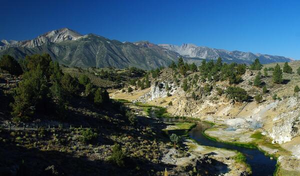
Hot Creek Gorge viewed upstream toward the SW; the steep walls of t...
Hot Creek Gorge viewed upstream toward the SW; the steep walls of t...Hot Creek Gorge viewed upstream toward the southwest; the steep walls of the gorge consist of a single rhyolite lava flow erupted from a vent 4 km (2.5 mi) to the south.
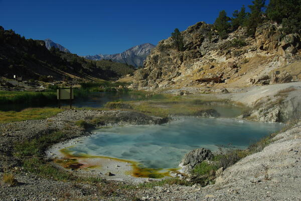
Bubbling Spring, a feature of Hot Creek in the Long Valley Caldera,...
Bubbling Spring, a feature of Hot Creek in the Long Valley Caldera,...Bubbling Spring, a feature of Hot Creek in the Long Valley Caldera, California, occasionally "boils" due to high water temperature.
Bubbling Spring, a feature of Hot Creek in the Long Valley Caldera,...
Bubbling Spring, a feature of Hot Creek in the Long Valley Caldera,...Bubbling Spring, a feature of Hot Creek in the Long Valley Caldera, California, occasionally "boils" due to high water temperature.

Seismic Lab aboard CCGS Louis S. St-Laurent
Seismic Lab aboard CCGS Louis S. St-Laurent
Seismic Lab aboard CCGS Louis S. St-Laurent

Soil-temperature measurement at Hot Creek in Long Valley Caldera, CA.
Soil-temperature measurement at Hot Creek in Long Valley Caldera, CA.Soil-temperature measurement at Hot Creek in Long Valley Caldera, California.
Soil-temperature measurement at Hot Creek in Long Valley Caldera, CA.
Soil-temperature measurement at Hot Creek in Long Valley Caldera, CA.Soil-temperature measurement at Hot Creek in Long Valley Caldera, California.

Helicopter dropping off monitoring equipment at Mount St. Helens, WA.
Helicopter dropping off monitoring equipment at Mount St. Helens, WA.Helicopter dropping off monitoring equipment at Mount St. Helens, Washington.
Helicopter dropping off monitoring equipment at Mount St. Helens, WA.
Helicopter dropping off monitoring equipment at Mount St. Helens, WA.Helicopter dropping off monitoring equipment at Mount St. Helens, Washington.

Volcano monitoring spider helps scientists understand signs and sym...
Volcano monitoring spider helps scientists understand signs and sym...The "spider" (a self-contained portable instrument package) was engineered and deployed during the 2004-2008 eruption of Mount St. Helens to detect and triangulate shallow earthquakes, monitor local ground deformation and uplift, detect lightning that might indicate an ash eruption and low frequency sound from explosions.

Flags flying high
U.S. and Canadian two icebreaker collaboration in the Arctic Ocean. Flags flying from CCGS Louis S. St-Laurent.
U.S. and Canadian two icebreaker collaboration in the Arctic Ocean. Flags flying from CCGS Louis S. St-Laurent.

PCMSC research vessel Parke Snavely on Nisqually Reach
PCMSC research vessel Parke Snavely on Nisqually ReachUSGS Pacific Coastal and Marine Science Center’s research vessel R/V Parke Snavely motors on the Nisqually Reach of Puget Sound.
PCMSC research vessel Parke Snavely on Nisqually Reach
PCMSC research vessel Parke Snavely on Nisqually ReachUSGS Pacific Coastal and Marine Science Center’s research vessel R/V Parke Snavely motors on the Nisqually Reach of Puget Sound.

View of the lava surface within the Overlook vent showing a crusted...
View of the lava surface within the Overlook vent showing a crusted...HVO geologists noted persistent spattering in the northeast corner of the lava lake within the Overlook vent during their night-time observations. The view of the lake surface was fairly good because of fume in the area of the Overlook was "thin" at the time.

Early morning glow from Overlook vent in Halema‘uma‘u, Kīlauea
Early morning glow from Overlook vent in Halema‘uma‘u, KīlaueaIncandescence from the lava lake surface (out of view) reflects an awesome glow on the gas plume rising from the lake surface.
Early morning glow from Overlook vent in Halema‘uma‘u, Kīlauea
Early morning glow from Overlook vent in Halema‘uma‘u, KīlaueaIncandescence from the lava lake surface (out of view) reflects an awesome glow on the gas plume rising from the lake surface.

Brain Coral Christmas
Christmas tree worms have made their home on a brain coral. Tropical corals reefs are complex ecosystems, but are rapidly being lost to bleaching and disease, linked to increasing water temperatures.
Christmas tree worms have made their home on a brain coral. Tropical corals reefs are complex ecosystems, but are rapidly being lost to bleaching and disease, linked to increasing water temperatures.

Station 1
The Upper monitoring station at Chalk Cliffs, CO.
The Upper monitoring station at Chalk Cliffs, CO.

Mount Bachelor, OR viewed from the east.
Mount Bachelor, Oregon viewed from the east.
Mount Bachelor, Oregon viewed from the east.

Hydrothermal explosion at Biscuit Basin in YNP. These types of even...
Hydrothermal explosion at Biscuit Basin in YNP. These types of even...Hydrothermal explosion at Biscuit Basin in Yellowstone National Park. These types of events are the most likely explosive hazard from the Yellowstone Volcano.
Hydrothermal explosion at Biscuit Basin in YNP. These types of even...
Hydrothermal explosion at Biscuit Basin in YNP. These types of even...Hydrothermal explosion at Biscuit Basin in Yellowstone National Park. These types of events are the most likely explosive hazard from the Yellowstone Volcano.