
Screenshot of the Aftershock Forecast for an earthquake in California, with the “Summary” tab selected, and “M4+” and “Show All” selections for magnitude and forecast duration.
Images
Images related to natural hazards.
Filter Total Items: 7275

Mendocino_M41month.jpg
Screenshot of the Aftershock Forecast for an earthquake in California, with the “Summary” tab selected, and “M4+” and “Show All” selections for magnitude and forecast duration.

Mendocino_map copy.jpg
Screenshot of the Aftershock Forecast for an earthquake in California, with the “Summary” tab selected, scrolled to the bottom of the page. The mainshock is shown with a yellow star on top of its circle; other earthquakes in the forecasting region are also shown colored by time of occurrence.
Screenshot of the Aftershock Forecast for an earthquake in California, with the “Summary” tab selected, scrolled to the bottom of the page. The mainshock is shown with a yellow star on top of its circle; other earthquakes in the forecasting region are also shown colored by time of occurrence.

Mendocino_parameters.jpg
Aftershock Forecast Model parameters screenshot of the Aftershock Forecast Overview page
Aftershock Forecast Model parameters screenshot of the Aftershock Forecast Overview page

Mendocino_M4all.jpg
Screenshot of the Aftershock Forecast for an earthquake in California, with the “Summary” tab selected, and “M4+” and “Show All” selections for magnitude and forecast duration.
Screenshot of the Aftershock Forecast for an earthquake in California, with the “Summary” tab selected, and “M4+” and “Show All” selections for magnitude and forecast duration.

Mendocino_table.jpg - Copy
Screenshot of the Aftershock Forecast for an earthquake in California, with the “Commentary” tab selected.
Screenshot of the Aftershock Forecast for an earthquake in California, with the “Commentary” tab selected.

Mendocino_table.jpg
Screenshot of the Aftershock Forecast for an earthquake in California, with the “Forecast Table” tab selected.
Screenshot of the Aftershock Forecast for an earthquake in California, with the “Forecast Table” tab selected.

fig4.gif
Two example aftershock sequences, from southern California, that illustrate the three general rules of aftershocks. A circle shows each aftershock's time of occurrence (horizontal axis) and magnitude (vertical axis). The larger-magnitude M6.7 Northridge earthquake is followed by many more aftershocks than the smaller M5.1 La Habra earthquake.
Two example aftershock sequences, from southern California, that illustrate the three general rules of aftershocks. A circle shows each aftershock's time of occurrence (horizontal axis) and magnitude (vertical axis). The larger-magnitude M6.7 Northridge earthquake is followed by many more aftershocks than the smaller M5.1 La Habra earthquake.

Aftershock Forecast on the earthquake event page
Screenshot of the Overview webpage for an earthquake in California. The “Aftershock Forecast” card is at lower center.
Screenshot of the Overview webpage for an earthquake in California. The “Aftershock Forecast” card is at lower center.

Aftershock Forecast for an earthquake in California
Aftershock Forecast for an earthquake in CaliforniaScreenshot of the Aftershock Forecast for an earthquake in California, with the “Summary” tab selected, and “Show All” and “1 Month” selections for magnitude and forecast duration.
Aftershock Forecast for an earthquake in California
Aftershock Forecast for an earthquake in CaliforniaScreenshot of the Aftershock Forecast for an earthquake in California, with the “Summary” tab selected, and “Show All” and “1 Month” selections for magnitude and forecast duration.

Hazard Risk and Society Venn Diagram
Ven diagram of risk as the intersection of hazards and society. This illustrates the logical relationships between two or more sets of items.
Ven diagram of risk as the intersection of hazards and society. This illustrates the logical relationships between two or more sets of items.

National Landslide Susceptibility Map Infographic
NATIONAL LANDSLIDE SUSCEPTIBILITY MAP

Postfire Debris Flow Science Infographic
POSTFIRE DEBRIS FLOW SCIENCE
The U.S. Geological Survey helps local, state, and federal agencies assess debris flow hazards in recently burned areas. We provide information about the likelihood of debris flow activity, where they might happen, and how big they might be.
DEBRIS FLOW ASSESSMENTS
POSTFIRE DEBRIS FLOW SCIENCE
The U.S. Geological Survey helps local, state, and federal agencies assess debris flow hazards in recently burned areas. We provide information about the likelihood of debris flow activity, where they might happen, and how big they might be.
DEBRIS FLOW ASSESSMENTS

Landslide Safety
LANDSLIDE SAFETY
If your home or property was damaged by a landslide from Hurricane Helene, be aware of the warning signs of future landslide activity
WATCH FOR WARNING SIGNS
Signs a landslide may be moving include:
LANDSLIDE SAFETY
If your home or property was damaged by a landslide from Hurricane Helene, be aware of the warning signs of future landslide activity
WATCH FOR WARNING SIGNS
Signs a landslide may be moving include:

Update on seismic activity at Mount Adams from September 2024 to early November 2024
Update on seismic activity at Mount Adams from September 2024 to early November 2024Volcanoes tend to have seismicity that waxes and wanes over time. That’s considered normal and not necessarily a cause for concern. Let’s check on Mount Adams to see what USGS scientists are doing to learn more about its recent earthquake activity and what it could mean for this Cascade Range volcano.
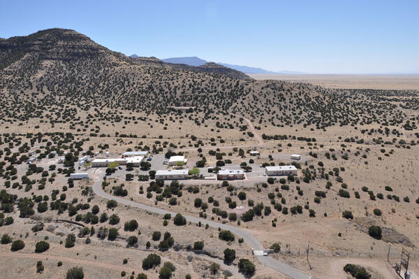
Aerial View of the Albuquerque Seismological Laboratory
Aerial View of the Albuquerque Seismological LaboratoryArial view from the North of the Albuquerque Seismological Laboratory on the Kirtland Air Force Base about 15 miles southeast of Albuquerque, New Mexico.
Aerial View of the Albuquerque Seismological Laboratory
Aerial View of the Albuquerque Seismological LaboratoryArial view from the North of the Albuquerque Seismological Laboratory on the Kirtland Air Force Base about 15 miles southeast of Albuquerque, New Mexico.

Seismographs at the Albuquerque Seismological Laboratory
Seismographs at the Albuquerque Seismological Laboratory(a) Photograph of instruments being tested in the East portion of the underground vault. (b) Wench and location of three boreholes in the West portion of the underground vault. (c) Cross-tunnel and recording equipment for the reference sensor vault.

Global Seismographic Network (GSN) Stations
Locations of the Global Seismographic Network (GSN) stations. USGS GSN sites are shown as pink circles and IRIS/IDA stations are shown as green circles. (as of October 2024)
Locations of the Global Seismographic Network (GSN) stations. USGS GSN sites are shown as pink circles and IRIS/IDA stations are shown as green circles. (as of October 2024)

I Am A...Volcanologist
Coloring page for geoscience careers. This page highlights those who want to become a volcanologist.
Coloring page for geoscience careers. This page highlights those who want to become a volcanologist.

Damage caused by a large mudflow in Buck Creek near Marion, NC. - 10/17/2024
Damage caused by a large mudflow in Buck Creek near Marion, NC. - 10/17/2024Coordinates of photographer: Latitude: 35° 44’ 16.08” N Longitude: 82° 8’ 20.04” W
Date: 10/17/24
Caption: Damage caused by a large mudflow in Buck Creek near Marion, NC.
Taken during Hurricane Helene LASER response

Damage caused by mudflows into Flat Creek near the Garren Creek Fire Station. - 10/17/2024
Damage caused by mudflows into Flat Creek near the Garren Creek Fire Station. - 10/17/2024Coordinates of photographer: Latitude: 35° 33’ 21.75” N, Longitude: 82° 19’ 0.9” W
Date: 10/17/24
Caption: Damage caused by mudflows into Flat Creek near the Garren Creek Fire Station. Some of the initiating landslides are visible in the distance, upper left of photo.
Taken during Hurricane Helene LASER response

I Am An...Archeologist
Coloring page for geoscience careers. This page highlights those who want to become an archeologist.
Coloring page for geoscience careers. This page highlights those who want to become an archeologist.