
The new eruption at the summit of Kīlauea volcano on September 10, 2023. After about an hour of increased seismic activity and uplift, HVO scientists observed the start of the eruption at approximately 3:15 p.m. HST.
Images
Images related to natural hazards.
Filter Total Items: 7275

Eruption at the summit of Kīlauea
The new eruption at the summit of Kīlauea volcano on September 10, 2023. After about an hour of increased seismic activity and uplift, HVO scientists observed the start of the eruption at approximately 3:15 p.m. HST.

Eruption at the summit of Kilauea volcano
An eruption at the summit of Kīlauea volcano began on September 10, 2023. The main fountain, which HVO geologists estimate is approximately 50 meters tall, is on the eastern margin of Halemaʻumaʻu crater. As of approximately 4:30 p.m.
An eruption at the summit of Kīlauea volcano began on September 10, 2023. The main fountain, which HVO geologists estimate is approximately 50 meters tall, is on the eastern margin of Halemaʻumaʻu crater. As of approximately 4:30 p.m.

Eruption at the summit of Kīlauea
From the Uēkahuna overlook, the new eruption at the summit of Kīlauea is visible. The farthest east fissure is near the to margin of downdropped block that formed during the 2018 summit collapse. The base of the main fissure, which is farthest west (right on the image), is approximately 70 meters wide.
From the Uēkahuna overlook, the new eruption at the summit of Kīlauea is visible. The farthest east fissure is near the to margin of downdropped block that formed during the 2018 summit collapse. The base of the main fissure, which is farthest west (right on the image), is approximately 70 meters wide.

Eruption at the summit of Kīlauea
The new eruption at the summit of Kīlauea volcano on September 10, 2023. After about an hour of increased seismic activity and uplift, HVO scientists observed the start of the eruption at approximately 3:15 p.m. HST.
The new eruption at the summit of Kīlauea volcano on September 10, 2023. After about an hour of increased seismic activity and uplift, HVO scientists observed the start of the eruption at approximately 3:15 p.m. HST.
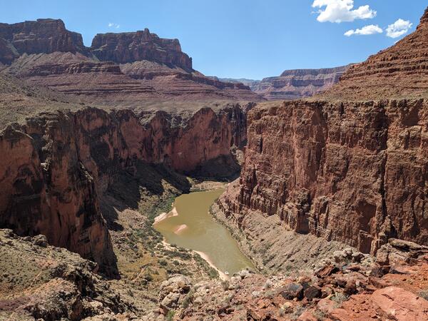
Grand_Canyon_20230908_Brennan.jpg
Photograph of the Colorado River in the Grand Canyon, Arizona, USA. Photo taken on September 8, 2023.
By
Core Science Systems Mission Area, Natural Hazards Mission Area, Water Resources Mission Area, Mineral Resources Program, National Cooperative Geologic Mapping Program, National Water Quality Program, Toxic Substances Hydrology, Geology, Geophysics, and Geochemistry Science Center, Geology, Minerals, Energy, and Geophysics Science Center, Geosciences and Environmental Change Science Center, New Mexico Water Science Center, Southwest Biological Science Center, Denver Radiogenic Isotope Lab, National Water Quality Laboratory, New Mexico Water Science Center Sediment Laboratory, Organic Geochemistry Laboratory, Geological Materials Repository, Geology and Ecology of National Parks, Colorado River Basin: Actionable and Strategic Integrated Science and Technology

Modeling to Support Proactive Approaches to Wildland Fire
Modeling to Support Proactive Approaches to Wildland FireScreen shot visualization of wind direction and velocity from a coupled/fire atmosphere model run of a wildfire (Dude Fire).
Modeling to Support Proactive Approaches to Wildland Fire
Modeling to Support Proactive Approaches to Wildland FireScreen shot visualization of wind direction and velocity from a coupled/fire atmosphere model run of a wildfire (Dude Fire).

Cover image for Preparedness Month Natural Hazards video
Cover image for Preparedness Month Natural Hazards videoCover image for the video Natural Hazards We Might Face, in support of National Preparedness Month.
Cover image for Preparedness Month Natural Hazards video
Cover image for Preparedness Month Natural Hazards videoCover image for the video Natural Hazards We Might Face, in support of National Preparedness Month.

Things to Know - Limitations_Infographic
Things to know about ShakeAlert graphic that shows the limitations of earthquake early warning.
Things to know about ShakeAlert graphic that shows the limitations of earthquake early warning.

The Elwha River: Landscapes of Discovery
Animated GIF of a cobbled streambed along the Elwha River in Washington State, from The Elwha River: Landscapes of Recovery Geonarrative
Animated GIF of a cobbled streambed along the Elwha River in Washington State, from The Elwha River: Landscapes of Recovery Geonarrative

Types of Landslides
TYPES OF LANDSLIDES

Creep
Creep is the imperceptibly slow, steady, downward movement of slope-forming soil or rock. Movement is caused by shear stress sufficient to produce permanent deformation, but too small to produce shear failure.
Creep is the imperceptibly slow, steady, downward movement of slope-forming soil or rock. Movement is caused by shear stress sufficient to produce permanent deformation, but too small to produce shear failure.

Debris Avalanche
Debris avalanche: This is a variety of very rapid to extremely rapid debris flow.
Debris avalanche: This is a variety of very rapid to extremely rapid debris flow.

Rockfall
Rockfalls are abrupt movements of masses of geologic materials, such as rocks and boulders, which become detached from steep slopes or cliffs. Separation occurs along discontinuities such as fractures, joints, and bedding planes, and movement occurs by free-fall, bouncing, and rolling.
Rockfalls are abrupt movements of masses of geologic materials, such as rocks and boulders, which become detached from steep slopes or cliffs. Separation occurs along discontinuities such as fractures, joints, and bedding planes, and movement occurs by free-fall, bouncing, and rolling.

Earthflow
Earthflows have a characteristic "hourglass" shape. The slope material liquefies and runs out, forming a bowl or depression at the head. The flow itself is elongated and usually occurs in fine-grained materials or clay-bearing rocks on moderate slopes and under saturated conditions. However, dry flows of granular material are also possible.
Earthflows have a characteristic "hourglass" shape. The slope material liquefies and runs out, forming a bowl or depression at the head. The flow itself is elongated and usually occurs in fine-grained materials or clay-bearing rocks on moderate slopes and under saturated conditions. However, dry flows of granular material are also possible.

Block Slide
A block slide is a translational slide in which the moving mass consists of a single unit or a few closely related units that move downslope as a relatively coherent mass.
A block slide is a translational slide in which the moving mass consists of a single unit or a few closely related units that move downslope as a relatively coherent mass.

Translational Landslide
Translational slide: In this type of slide, the landslide mass moves along a roughly planar surface with little rotation or backward tilting.
Translational slide: In this type of slide, the landslide mass moves along a roughly planar surface with little rotation or backward tilting.

Debris Flow
A debris flow is a form of rapid mass movement in which a combination of loose soil, rock, organic matter, air, and water mobilizes as a slurry that flows downslope. Debris flows include <50% fines.
A debris flow is a form of rapid mass movement in which a combination of loose soil, rock, organic matter, air, and water mobilizes as a slurry that flows downslope. Debris flows include <50% fines.

Lateral Spread
Lateral spreads are distinctive because they usually occur on very gentle slopes or flat terrain. The dominant mode of movement is lateral extension accompanied by shear or tensile fractures.
Lateral spreads are distinctive because they usually occur on very gentle slopes or flat terrain. The dominant mode of movement is lateral extension accompanied by shear or tensile fractures.

Topple
Toppling failures are distinguished by the forward rotation of a unit or units about some pivotal point, below or low in the unit, under the actions of gravity and forces exerted by adjacent units or by fluids in cracks.
Toppling failures are distinguished by the forward rotation of a unit or units about some pivotal point, below or low in the unit, under the actions of gravity and forces exerted by adjacent units or by fluids in cracks.

Rotational Landslide
Rotational slide: This is a slide in which the surface of rupture is curved concavely upward and the slide movement is roughly rotational about an axis that is parallel to the ground surface and transverse across the slide.
Rotational slide: This is a slide in which the surface of rupture is curved concavely upward and the slide movement is roughly rotational about an axis that is parallel to the ground surface and transverse across the slide.

Earthquakes: What You Feel
EARTHQUAKES: WHAT YOU FEEL
EARTHQUAKE INTENSITY
EARTHQUAKES: WHAT YOU FEEL
EARTHQUAKE INTENSITY