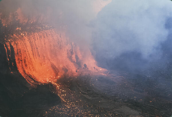
Lava fountain of June 25, 1969, This fountain lasted a little over ...
Lava fountain of June 25, 1969, This fountain lasted a little over ...It is a good example of what many volcanologists term a Hawaiian fountain.

Official websites use .gov
A .gov website belongs to an official government organization in the United States.
Secure .gov websites use HTTPS
A lock () or https:// means you’ve safely connected to the .gov website. Share sensitive information only on official, secure websites.
Images related to natural hazards.

It is a good example of what many volcanologists term a Hawaiian fountain.
It is a good example of what many volcanologists term a Hawaiian fountain.

‘Ālo‘i Crater (top) chokes in fume rising from new lava. A slightly sinuous line connecting Mauna Ulu and ‘Ālo‘i is row of spatter cones formed on May 24. View looks west, with trade wind blowing.
‘Ālo‘i Crater (top) chokes in fume rising from new lava. A slightly sinuous line connecting Mauna Ulu and ‘Ālo‘i is row of spatter cones formed on May 24. View looks west, with trade wind blowing.

A series of wide fractures cut across Chain of Craters Road in Hawai‘i Volcanoes National Park during an eruption of Kīlauea in February 1969. These fractures were related to a "slump block" that developed on the southwest rim of ‘Alae Crater on the volcano's East Rift Zone.
A series of wide fractures cut across Chain of Craters Road in Hawai‘i Volcanoes National Park during an eruption of Kīlauea in February 1969. These fractures were related to a "slump block" that developed on the southwest rim of ‘Alae Crater on the volcano's East Rift Zone.
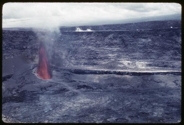
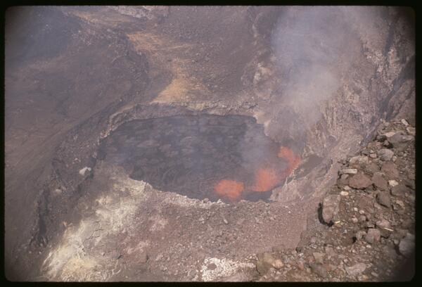
The February 1969 rift eruption near Nāpau Crater was a brief but dynamic precursor to the long-lived Maunaulu eruption that began in May of that year. This week-long event featured lava fountaining from multiple fissures along a 2.5-mile stretch of Kīlauea’s upper East Rift Zone.
The February 1969 rift eruption near Nāpau Crater was a brief but dynamic precursor to the long-lived Maunaulu eruption that began in May of that year. This week-long event featured lava fountaining from multiple fissures along a 2.5-mile stretch of Kīlauea’s upper East Rift Zone.

Shoestring Glacier on Mount St. Helens, viewed from the southeast. Photo from May, 1965.
Shoestring Glacier on Mount St. Helens, viewed from the southeast. Photo from May, 1965.

Photograph taken in 1964 of the main part of the Chenega village site in Alaska. Pilings in the ground mark the former locations of homes swept away by tsunami waves. The schoolhouse on high ground was undamaged.
Photograph taken in 1964 of the main part of the Chenega village site in Alaska. Pilings in the ground mark the former locations of homes swept away by tsunami waves. The schoolhouse on high ground was undamaged.

Aerial photo of Mount St. Helens taken from the northeast in September 1964.
Aerial photo of Mount St. Helens taken from the northeast in September 1964.
The 1961 fissure eruption near Nāpau Crater was a short-lived but notable event on Kīlauea’s East Rift Zone, occurring in late September. Over two days, lava erupted from vents along a 13-mile stretch, producing 13 small flows and lava fountains that reached heights of up to 400 feet, with the largest flows occurring near Pāhoa.
The 1961 fissure eruption near Nāpau Crater was a short-lived but notable event on Kīlauea’s East Rift Zone, occurring in late September. Over two days, lava erupted from vents along a 13-mile stretch, producing 13 small flows and lava fountains that reached heights of up to 400 feet, with the largest flows occurring near Pāhoa.
The July 1961 eruption at Halemaʻumaʻu was the third summit eruption of that year, continuing the pattern of vigorous volcanic activity at Kīlauea. This event featured sustained lava fountaining and further infilling of the crater, building upon the changes initiated by the February and March eruptions.
The July 1961 eruption at Halemaʻumaʻu was the third summit eruption of that year, continuing the pattern of vigorous volcanic activity at Kīlauea. This event featured sustained lava fountaining and further infilling of the crater, building upon the changes initiated by the February and March eruptions.
The March 1961 eruption at Halemaʻumaʻu was the second of three summit eruptions at Kīlauea that year, marked by renewed lava activity within the northeast collapse pit formed in February. This phase featured vigorous lava fountaining, crater floor uplift, and the gradual infilling of the pit, reflecting continued magma supply and dynamic summit processes.
The March 1961 eruption at Halemaʻumaʻu was the second of three summit eruptions at Kīlauea that year, marked by renewed lava activity within the northeast collapse pit formed in February. This phase featured vigorous lava fountaining, crater floor uplift, and the gradual infilling of the pit, reflecting continued magma supply and dynamic summit processes.
The February 1961 summit eruption of Kīlauea marked the beginning of a year of intense volcanic activity, characterized by three distinct summit eruptive phases.
The February 1961 summit eruption of Kīlauea marked the beginning of a year of intense volcanic activity, characterized by three distinct summit eruptive phases.

Aftermath of the 1960 Chilean tsunami in Hilo, Hawaii, where the tsunami caused 61 deaths.
Aftermath of the 1960 Chilean tsunami in Hilo, Hawaii, where the tsunami caused 61 deaths.

‘A‘ā flow has just reached the barrier built between KUKi‘i and Kapoho.
‘A‘ā flow has just reached the barrier built between KUKi‘i and Kapoho.

The high front of an advancing ‘A‘ā flow forms the ridge between the papaya orchard and the fountain. The defoliation had occurred by January 16, 1960.
The high front of an advancing ‘A‘ā flow forms the ridge between the papaya orchard and the fountain. The defoliation had occurred by January 16, 1960.

House belonging to the Hongo family set fire by advancing ‘A‘ā in the foreground, 1800 January 16, 1960. Note fountain behind tree near right edge of view.
House belonging to the Hongo family set fire by advancing ‘A‘ā in the foreground, 1800 January 16, 1960. Note fountain behind tree near right edge of view.

A river of ‘A‘ā is pouring from the far side of the cone and moving to the right, hemmed in by the scarp along the Koa‘e fault, visible between the fountain and the right edge of the photo.
A river of ‘A‘ā is pouring from the far side of the cone and moving to the right, hemmed in by the scarp along the Koa‘e fault, visible between the fountain and the right edge of the photo.

Incandescent lava particles can be seen above the fountain between the light and dark steam clouds. Photo looking uprift toward area of vent C, taken at 1000 January 14 by D.H. Richter. Left-hand lava fountain may be vent B.
Incandescent lava particles can be seen above the fountain between the light and dark steam clouds. Photo looking uprift toward area of vent C, taken at 1000 January 14 by D.H. Richter. Left-hand lava fountain may be vent B.

View westward along the Kapoho fault scarp in the village of Kapoho following a swarm of earthquakes in the area. The ground cracking was caused by subsidence of a graben (down-dropped block) that spanned the community.
View westward along the Kapoho fault scarp in the village of Kapoho following a swarm of earthquakes in the area. The ground cracking was caused by subsidence of a graben (down-dropped block) that spanned the community.

Fractures along the Kapoho fault hours after an earthquake swarm began in the area early on January 13, 1960. Residents in and near Kapoho village reported feeling the earthquakes, and HVO scientists on the scene described "the ground beneath our feet in almost constant motion" and hearing "low-pitched booming sounds" accompanying the largest earthquakes.
Fractures along the Kapoho fault hours after an earthquake swarm began in the area early on January 13, 1960. Residents in and near Kapoho village reported feeling the earthquakes, and HVO scientists on the scene described "the ground beneath our feet in almost constant motion" and hearing "low-pitched booming sounds" accompanying the largest earthquakes.

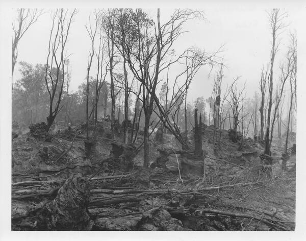
Coconut palms were stripped by heavy tephra fall during the Kapoho eruption. These lie north of the fissure with volcanic bomb craters indenting the tephra on the flank of the new cone, Pu‘u Laimana.
Coconut palms were stripped by heavy tephra fall during the Kapoho eruption. These lie north of the fissure with volcanic bomb craters indenting the tephra on the flank of the new cone, Pu‘u Laimana.

This house fell into Hebgen Lake during the 1959 earthquake and floated along the shore until it came to rest here. The owner of the house, then-70-year-old Mrs. Grace Miller, escaped only after kicking out her front door and leaping a 5-foot-wide ground crack as her house dropped into the lake.
This house fell into Hebgen Lake during the 1959 earthquake and floated along the shore until it came to rest here. The owner of the house, then-70-year-old Mrs. Grace Miller, escaped only after kicking out her front door and leaping a 5-foot-wide ground crack as her house dropped into the lake.