
Meagan Gonneea checks on instruments at a tidal creek in Great Pond, Falmouth, MA. Daily tides drive exchange between coastal wetlands and adjacent estuaries. Here we have instrumented a tidal channel to measure those fluxes over a tidal cycle. When the marsh floods, material is imported from the estuary.
Images
Images related to natural hazards.
Filter Total Items: 7275

Instrument check at a tidal creek, Falmouth, MA
Meagan Gonneea checks on instruments at a tidal creek in Great Pond, Falmouth, MA. Daily tides drive exchange between coastal wetlands and adjacent estuaries. Here we have instrumented a tidal channel to measure those fluxes over a tidal cycle. When the marsh floods, material is imported from the estuary.

Salt Marsh Well Sensor
A well sensor continuously monitors salinity, temperature, and water level in a salt marsh, Cape Cod, MA
A well sensor continuously monitors salinity, temperature, and water level in a salt marsh, Cape Cod, MA

Amphitheater Mountain viewed from the northeast entrance road. NPS photo by Jaco
Amphitheater Mountain viewed from the northeast entrance road. NPS photo by JacoAmphitheater Mountain and Soda Butte Creek viewed from the northeast entrance road. National Park Service photo by Jacob Frank, June 29, 2017.

Gamma well detectors
Gamma well detectors are used to determine the ages of sediments based on activities of natural and anthropogenic radionuclides
Gamma well detectors are used to determine the ages of sediments based on activities of natural and anthropogenic radionuclides

Coulmeter
Dissolved inorganic carbon (DIC) in water samples is measured with a UIC, Inc. Coulometer
Dissolved inorganic carbon (DIC) in water samples is measured with a UIC, Inc. Coulometer

Isla Verde, San Juan, Puerto Rico
The urban reef at Isla Verde supports various species of protected corals, sea turtles, and crustaceans, as well as many Caribbean fish. It also protects the International Airport and numerous homes and resorts on the coast.
The urban reef at Isla Verde supports various species of protected corals, sea turtles, and crustaceans, as well as many Caribbean fish. It also protects the International Airport and numerous homes and resorts on the coast.
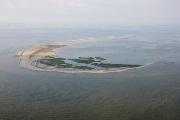
Aerial photograph looking southwest along Breton Island, Louisiana
Aerial photograph looking southwest along Breton Island, LouisianaAerial photograph looking southwest along Breton Island, Louisiana, taken July 2013
Aerial photograph looking southwest along Breton Island, Louisiana
Aerial photograph looking southwest along Breton Island, LouisianaAerial photograph looking southwest along Breton Island, Louisiana, taken July 2013

An HVO geologist walks along the summit trail, with Mauna Kea in the background.
An HVO geologist walks along the summit trail, with Mauna Kea in the background.An HVO geologist walks along the summit trail, with Mauna Kea in the background.
An HVO geologist walks along the summit trail, with Mauna Kea in the background.
An HVO geologist walks along the summit trail, with Mauna Kea in the background.An HVO geologist walks along the summit trail, with Mauna Kea in the background.

Webcam check at Halema‘uma‘u
HVO geologists made a routine visit to the webcam monitoring Halema‘uma‘u. No changes were observed in the pit, but views were hampered by poor weather and thick fog.
HVO geologists made a routine visit to the webcam monitoring Halema‘uma‘u. No changes were observed in the pit, but views were hampered by poor weather and thick fog.

Routine visit to Mauna Loa summit
HVO staff visited the summit of Mauna Loa on foot to repair the webcam. The weather was perfectly clear, and views of the caldera floor showed nothing unusual.
HVO staff visited the summit of Mauna Loa on foot to repair the webcam. The weather was perfectly clear, and views of the caldera floor showed nothing unusual.

Map showing the minimum area covered by volcanic ash from eruptions of Valles Ca
Map showing the minimum area covered by volcanic ash from eruptions of Valles CaMap showing the minimum area covered by volcanic ash from eruptions of Valles Ca
Map showing the minimum area covered by volcanic ash from eruptions of Valles Ca
Map showing the minimum area covered by volcanic ash from eruptions of Valles CaMap showing the minimum area covered by volcanic ash from eruptions of Valles Ca

USGS researchers ride along the dune; Kennedy Space Center in distance
USGS researchers ride along the dune; Kennedy Space Center in distanceThe USGS collaborates with NASA, the University of Florida, National Park Service, and the U.S. Fish and Wildlife Service to assess coastal erosion hazards affecting space program infrastructure, habitat, and wildlife populations.

Serapeum, a Roman marketplace in the center of Pozzuoli, near Naples, Italy.
Serapeum, a Roman marketplace in the center of Pozzuoli, near Naples, Italy.Serapeum, a Roman Marketplace in Pozzuoli, Italy, records deformation of Campi Flegrei caldera over two millennia. It was built above sea level about 2000 years ago, but mollusk borings on the large marble columns indicate that it subsided by 7 meters (23 feet) below sea level before being uplifted above sea level once more in the past several hundred years.

Cape Cod hazards
USGS geologists Dave Foster and Wayne Baldwin and Andrew Green (University of
KwaZulu-Natal) observe coastal hazards on the Lower Cape, Massachusetts.
USGS geologists Dave Foster and Wayne Baldwin and Andrew Green (University of
KwaZulu-Natal) observe coastal hazards on the Lower Cape, Massachusetts.

Unalakleet video camera snapshot
Two video cameras overlook the coast from atop a windmill tower in Unalakleet, Alaska where they look westward over Norton Sound. This is a snapshot taken from one of the cameras.
Two video cameras overlook the coast from atop a windmill tower in Unalakleet, Alaska where they look westward over Norton Sound. This is a snapshot taken from one of the cameras.

MultiGAS instruments monitor volcanic gases at the summit
MultiGAS instruments monitor volcanic gases at the summitHawaiian Volcano Observatory field crews establish a new MultiGAS volcanic gas monitoring station on the south side of Kīlauea Volcano's caldera. Currently, sulfur dioxide emission rates from the summit remain low. The station will collect data to track emission rates and concentrations over time. Photo by Frank Younger.

HVO scientists inspect a seismic station on Mauna Loa to evaluate for a possible
HVO scientists inspect a seismic station on Mauna Loa to evaluate for a possibleHVO scientists inspect a seismic station on Mauna Loa to evaluate for a possible equipment upgrade in the near future.
HVO scientists inspect a seismic station on Mauna Loa to evaluate for a possible
HVO scientists inspect a seismic station on Mauna Loa to evaluate for a possibleHVO scientists inspect a seismic station on Mauna Loa to evaluate for a possible equipment upgrade in the near future.

HVO scientists check out monitoring instruments on Mauna Loa
HVO scientists check out monitoring instruments on Mauna LoaHVO scientists measure a GPS instrument to ensure its stability during a multi-day deployment in the Kahuku Unit of Hawai‘i Volcanoes National Park.
HVO scientists check out monitoring instruments on Mauna Loa
HVO scientists check out monitoring instruments on Mauna LoaHVO scientists measure a GPS instrument to ensure its stability during a multi-day deployment in the Kahuku Unit of Hawai‘i Volcanoes National Park.

miniSEABOSS deployment off the R/V Petrel
Wayne Baldwin (USGS, far right) with students and staff from Stockton University getting ready to deploy the miniSEABOSS off the R/V Petrel during the geological sampling survey in October 2018.
Wayne Baldwin (USGS, far right) with students and staff from Stockton University getting ready to deploy the miniSEABOSS off the R/V Petrel during the geological sampling survey in October 2018.

What caused—or did not cause—the 2018 Kīlauea eruption?
What caused—or did not cause—the 2018 Kīlauea eruption?Earthquakes (red dots) track the progression of the magmatic intrusion from Kīlauea Volcano's middle East Rift Zone to the lower East Rift Zone between April 30 and May 3, 2018. Orange triangles show the locations of fissure 1 (right), which erupted on May 3, and Pu‘u ‘Ō‘ō (left).

Maps displaying the stages of evolution of the more recent cycle of volcanism as
Maps displaying the stages of evolution of the more recent cycle of volcanism asMaps displaying the stages of evolution of the more recent cycle of volcanism associated with Yellowstone Caldera. From Finn and Morgan, 2002 (High-resolution aeromagnetic mapping of volcanic terrain, Yellowstone National Park).