
Long Island marsh water
Images
Explore water-related photography, imagery, and illustrations.
Filter Total Items: 2553

Long Island marsh water

Appomattox River at Matoaca
Flooding in Appomattox River at Matoaca
Flooding in Appomattox River at Matoaca

Evaportranspiration equipment along the Tracey Segment
Evaportranspiration equipment along the Tracey SegmentEvaportranspiration equipment along the Tracey Segment
Evaportranspiration equipment along the Tracey Segment
Evaportranspiration equipment along the Tracey SegmentEvaportranspiration equipment along the Tracey Segment

Aufeis
Paul Schuster, USGS, holding an ice core of Aufice (meaning over ice). Each layer represents a groundwater overflow event. Groundwater flows are predicted to increase with warming temperatures likely affecting the formation of Aufice in the Yukon River basin.
Paul Schuster, USGS, holding an ice core of Aufice (meaning over ice). Each layer represents a groundwater overflow event. Groundwater flows are predicted to increase with warming temperatures likely affecting the formation of Aufice in the Yukon River basin.

USGS Scientist Mark Roth listening to frog calls.
USGS Scientist Mark Roth listening to frog calls. Coolecting frog calls allows scientists to determine distribution of species.
USGS Scientist Mark Roth listening to frog calls. Coolecting frog calls allows scientists to determine distribution of species.

Public Wells
Example of wellhead plumbing typical of public wells sampled in a USGS study of 932 public wells nationwide. About 105 million peopleor more than one-third of the Nation's populationreceive their drinking water from one of the 140,000 public water systems across the United States that rely on groundwater pumped from public wells.
Example of wellhead plumbing typical of public wells sampled in a USGS study of 932 public wells nationwide. About 105 million peopleor more than one-third of the Nation's populationreceive their drinking water from one of the 140,000 public water systems across the United States that rely on groundwater pumped from public wells.

Manatee Spring
Manatee Spring looking toward main vent. One of many springs in Florida USGS began a data collection on in 2001.
Manatee Spring looking toward main vent. One of many springs in Florida USGS began a data collection on in 2001.

Alapaha River Draining Into Sink
View of the Alalpaha River draining into a sink in the riverbed during a major drought.
View of the Alalpaha River draining into a sink in the riverbed during a major drought.

South Africa Coast and Urban Development
View of mountainous coastline in South Africa showing urban development.
View of mountainous coastline in South Africa showing urban development.

South Africa Coastline
Scenic view of coastline in South Africa.
Scenic view of coastline in South Africa.

Rio Grande and Cliffs in Boquillas Canyon, Big Bend National Park
Rio Grande and Cliffs in Boquillas Canyon, Big Bend National ParkThe Rio Grande as it flows in Big Bend National Park, mostly flow from the Rio Conchos in Mexico. The canyon is downstream of the USGS gage.
Rio Grande and Cliffs in Boquillas Canyon, Big Bend National Park
Rio Grande and Cliffs in Boquillas Canyon, Big Bend National ParkThe Rio Grande as it flows in Big Bend National Park, mostly flow from the Rio Conchos in Mexico. The canyon is downstream of the USGS gage.

NYWSC_HydroacousticTurbidity
Dan Edwards and Gary Wall attach a hydroacoustic and turbidity equipment package to a tripod for deployment on the bottom of the Hudson River near Poughkeepsie, NY
Dan Edwards and Gary Wall attach a hydroacoustic and turbidity equipment package to a tripod for deployment on the bottom of the Hudson River near Poughkeepsie, NY

Medina River Winter View at Bandera, TX
Clear cool water over a limestone rock and gravel riverbed is characteristic of many Texas Hill County Creeks and Rivers.
Clear cool water over a limestone rock and gravel riverbed is characteristic of many Texas Hill County Creeks and Rivers.

USGS regional research drill rig near Truckee River, NV
USGS regional research drill rig near Truckee River, NVUSGS regional research drill rig constructing sites near the south bank of the Truckee River just downstream of USGS 10350000 Truckee River at Vista. The wells were constructed to investigate surface water groundwater interaction.

Batavia Kill at Red Falls, Greene County, NY
Batavia Kill at Red Falls, Greene County, NY

Water sampling in tidal marsh on Long Island
USGS scientists taking water samples in the tidal marsh on Long Island.
USGS scientists taking water samples in the tidal marsh on Long Island.
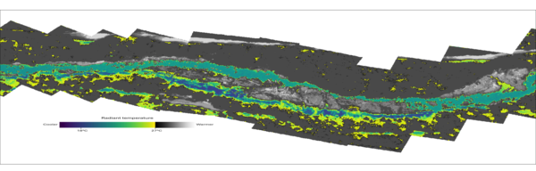
Thermal infrared mosaic of Quartzville Creek, OR
Thermal infrared mosaic of Quartzville Creek, OR. These images were captured on the year 2000 as part of an airborne thermal infrared survey conducted in the Santiam River basin, OR. The images were orthorectified and mosaicked into a single raster in order to identify and visualize thermal heterogeneity.
Thermal infrared mosaic of Quartzville Creek, OR. These images were captured on the year 2000 as part of an airborne thermal infrared survey conducted in the Santiam River basin, OR. The images were orthorectified and mosaicked into a single raster in order to identify and visualize thermal heterogeneity.


Domestic (private) well
More than 40 million people in the U.S. rely on domestic wells, like the one shown here, for their drinking water. Concentrations of groundwater at the wellhead typically are low, but lead can leach into the water from corrosion of household plumbing that contains lead.
More than 40 million people in the U.S. rely on domestic wells, like the one shown here, for their drinking water. Concentrations of groundwater at the wellhead typically are low, but lead can leach into the water from corrosion of household plumbing that contains lead.

Long Island core samples
Long Island core samples

Groundwater Sampling on Long Island
Groundwater sampling for water quality on Long Island, New York
Groundwater sampling for water quality on Long Island, New York